Active uplift and deformation in the Santa Maria Basin

The Santa Maria Basin is bounded on the south and northeast by two major reverse faults of the western Transverse Ranges (WTR) that are lifting the Santa Ynez and San Rafael mountains. However, abundant fluvial strath terraces throughout the Santa Maria Basin show that uplift is also occurring in the footwall of these reverse faults, indicating a regional component of uplift is present, most likely from deeper structures beneath the WTR. My students and I are working to determine the kinematics and amount of Quaternary deformation in the Santa Maria Basin and to investigate the underlying cause of regional uplift and shortening in the WTR. Completed work (see below) has focused mainly on documenting Quaternary deformation recorded by fluvial terraces in the Santa Ynez Valley, and the kinematic history of the Little Pine Fault, Santa Ynez Fault, and other structures in the area. Current and future work includes 1. Expanding on the quantification of active deformation using mapping, surveying, and Luminescence dating of Quaternary terrace deposits, 2. Using Quaternary stratigraphic horizons to reconstruct the growth rate and amount of active folds, and 3. Documenting the recency of faulting, slip rate, and slip kinematics of the major faults in the area. Much of our early work was been funded by a grant from the Petroleum Research Fund.
Completed work in the Santa Maria Basin area by my graduate students includes:
Andrew Farris has mapped, described, and dated fluvial terraces (using postIR- IRSL) along Zaca Creek to quantify Quaternary deformation and regional uplift in the area. He found that minimum uplift rates are around 1 mm/yr, and identified Late Quaternary deformation along folds and faults that cross Zaca Creek.
Ani Pytlewski has mapped and surveyed Pleistocene fluvial terraces along the upper Santa Ynez river and is using OSL to date them. These data are being used to calculate the amount and rate of regional uplift, as well as constrain the recency of slip along the Santa Ynez fault.
Yannick Wirtz found that shortening across the Santa Maria Basin is greater than is represented in the large-scale restored cross-sections by Namson and Davis (1988), and that the amount and style of shortening is highly dependent on the lithology of the units used as markers. To do this, he measured the amount of shortening across the Santa Maria Basin at a variety of scales, focusing on retrodeforming new 2 to 4 km long cross-sections for parts of the basin as well as measuring shortening at the outcrop scale.
Todd Tyler mapped and dated (using IRSL) terraces in Santa Cruz Creek to measure regional uplift and Quaternary activity of faults and folds that cross Santa Cruz Creek in the eastern Santa Maria Basin. He found that the Los Alamos-Baseline fault offsets a 30 Ka terrace by about 30 m (roughly 1 mm/yr slip rate) and that the height of the Quaternary terraces above the active channel suggest a regional uplift rate of between 1.2 and 1.8 mm/yr.
Mike Cannon collected kinematic data along the Little Pine fault (the major fault that marks the north side of the Santa Maria Basin) and found that the fault has experienced variable styles of slip, both along strike and through time. His work suggests that there may have been a late Miocene history of right-lateral slip along the fault, but since Pliocene or early Pleistocene time the fault has primarily moved as a reverse fault that dies out to the northwest in the Zaca Creek area.
Rick Lee looked at the sedimentology of the Pleistocene Paso Robles formation, as well as the Quaternary terrace material and active alluvium to evaluate the slip history of the Little Pine fault. He also found evidence that the Little Pine fault has experienced primarily reverse slip since Pliocene time.
Jon Guillaume collected paleomagnetic data from Miocene rocks to see if the Santa Maria Basin experienced large scale clockwise rotation like the western Transverse Ranges to the south. Unfortunately all the samples collected from the Monterey and Siquoc formations were re-magnetized, so we are still unsure how much rotation the rocks in the basin have experienced.


The Big Pine Fault
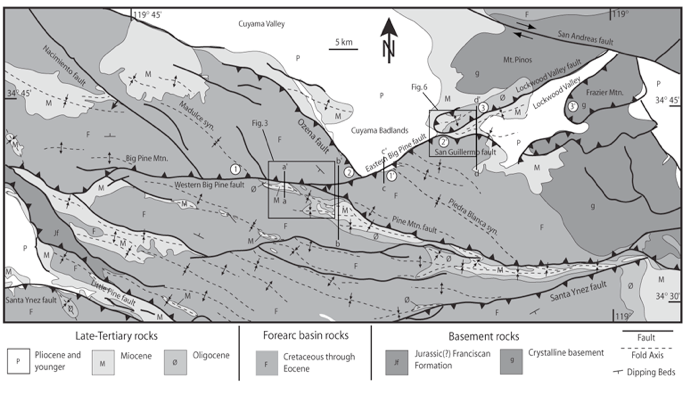
The Big Pine fault is an east-west striking fault zone that extends 70km westward from the Big Bend of the San Andreas fault zone in southern California (Figure 1). The fault trend lies at the boundary between the west-trending Transverse Ranges, dominated by north-south shortening, and the northwest-trending transpressional Coast Ranges. Its location and extent make it an integral part of tectonic reconstructions because the fault trend provides the link between these two contrasting structural domains of the San Andreas plate boundary. However, geologic reconstructions have not been able to fully reconcile block motions with the previously reported kinematics along the fault (e.g., Powell, 1993; Ingersoll and Rumelhart, 1999).


Mapping along the Big Pine fault trend in southern California indicates that this structural alignment is actually three separate faults, which exhibit different geometries, slip histories, and senses of offset since Miocene time. The easternmost fault, along the north side of Lockwood Valley, exhibits left-lateral reverse Quaternary displacement, but was a north-dipping normal fault in late Oligocene to early Miocene time. The Eastern Big Pine fault that bounds the southern edge of the Cuyama Badlands is a south-dipping reverse fault that is continuous with the San Guillermo fault. The western segment of the Big Pine fault trend is a north-dipping thrust fault continuous with the Pine Mountain fault and delineates the northern boundary of the rotated western Transverse Ranges terrane. This redefinition of the Big Pine fault differs greatly from the previous interpretation and significantly alters regional tectonic models and seismic risk estimates. For details, please see the PDF on my publications page.
