Mapping Population Dynamics
WEEK TWELVE: INDIVIDUAL POPULATION MAPPING PROJECT
(You should have a topic in
mind TO DISCUSS in class on Monday, May 24th)
WEEK ELEVEN: ANIMATED POPULATION MAPS
-
LA -- No More MINORITIES
The "Race Contours" Project in Los Angeles
(check out the many Animated Maps on this Page by the same author)
Race and Housing Values??
-
Mapping an Epidemic -- AIDS
-
Mapping History -- "Growth of a Nation"
-
Mapping Environmental Change
(use PowerPoint Options)
WEEK TEN: Mapping MIGRATION
-
READINGS
-
Examples
WEEK NINE: Diversity Map Production
-
Create Maps of Ethnic/Racial Diversity in DC
-
Finish by Mittwoch
WEEK EIGHT: Diversity Continued
NEW DC_map files (with all race data) DOWNLOAD
-
Advanced Measures of Diversity
-
SAMPLE MAPS and Applications
-
USA Today Interactive Theme: Diversity
-
Eugene Turner on Los Angeles
-
WEEK SEVEN: MAPPING DIVERSITY
-
City of Washington, D.C. Census Tract Shapefile .. Download
-
Some Readings and "Lessons" Used to explore diversity in D.C.:
-
Reading: "Introduction: Washington, D.C., Lessons on Diversity and Change"
-
Mumford Report, "Ethnic Diversity Grows"
-
Exploring and Examining Racial and Ethnic Diversity , Population Reference Bureau (PRB)
This is a "Lesson Plan" developed by the PRB for Teachers. You should be able to do some of the exercises using GIS and/or Spreadsheet software. There are "Hand-Outs" which students would use to do some calculations by hand.
You are NOT expected to do all the work described in this "lesson," but it would be useful to read the materials, look at the hand-outs and try to understand the concepts and terminology.
-
WEEK SIX: ATLAS ASSIGNMENT DUE WEDNESDAY
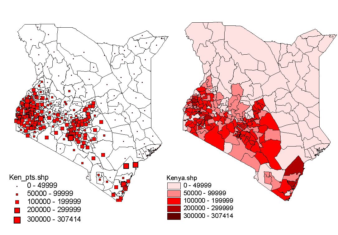
REMEMBER .. Population Counts should NOT normally be mapped as AREAS!
WEEK FIVE
AFRICA POPULATION ATLAS:
An Atlas is a series of related maps of an area, usually with a specific theme. Our theme is Population for the part of Africa you have chosen. Create a series of Population maps showing different topics. You can use the US Census ATLAS of DIVERSITY as a model for the kinds of topics and types of maps you might produce. You should produce a minimum of FOUR (4) MAPS:
A map showing Total Population by administrative areas (see below);
A map of Population Density by administrative areas;
A map of Population Change from 1980 to 1990;
A map of your own choice of topic.
Each map should employ the same basic DESIGN/Layout -- size of map, position of titles and legends, scale and other text.
This ASSIGNMENT is DUE Wednesday, April 21, 2004 at 17:00.
Mapping population counts as Graduated Point Symbols.
Download "Population Centers" for African Administrative Areas (Shapefile of POINTS)
WEEK FOUR
-
READING: US Census Atlas of Diversity
-
Look especially at these Maps:
-
What can we learn from their design?
-
Which ones are Good? Which would Prof Gossette not like
 ?
?
-
-
-
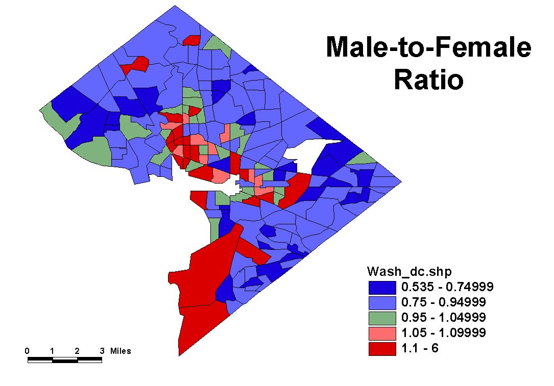
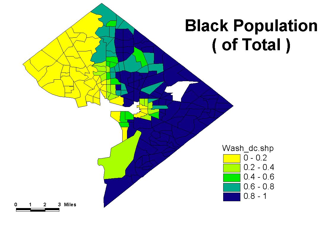
OBSERVATIONS: Race and Gender in Washington DC
-
DC Shapefile -- Download to Explore Data
WEEK THREE
-
Your first map
-
Choose an individual country or region of Africa to map
-
Choose an appropriate Standardized Measure for a Choropleth Map
-
Choose a classification method based on the map Data distribution
-
Choose appropriate map symbols
-
Add a Title and Legend to the map layout
-
Export the finished map to a digital image file
-
E-mail me your map :-)
-
WEEK TWO
-
READING/REVIEW:
-
Lecture Topics:
-
Geographic Information: Features and Attributes
-
Types of Features in GIS/Cartography: Points, Lines, Areas, Surfaces
-
Types of Attribute "Variables": Nominal and Numeric
-
The Feature Type x Attribute Type Matrix
-
Filling in the Matrix with Symbol Types
-
-
Interactive Practice Mapping: Data Generalization
-
Map Total Population for Colorado and Virginia
-
Experiment with different number of classes
-
Try different classification methods
-
WHY can't we make a "Good" map of Colorado Population? What's wrong?
-
Choose an Appropriate Theme to COMPARE Colorado and Virginia
-
WEEK ONE
-
READING/REVIEW: Cartographic Communication
This reading comes from The Geographer's Craft Project, a very useful source for concise information and instruction in GIS. Read Sections 1 to 4. These ideas will form the basis for our discussion and comparison of your SAMPLE MAP [Electronic Map of Some Population Theme from your country of choice.]
-
On-Line Tutorial : The Basics of ArcGIS -- ESRI Virtual Campus
The ESRI Virtual Campus is accessed through your web browser at: http://campus.esri.com . ESRI requires you to sign in as a student or guest to gain entrance to the various exercise modules. The registration process should be free for these modules.
If you DO NOT HAVE and EXISTING ACCOUNT, then Create a Free Member Account. BE SURE TO WRITE DOWN YOUR LOGIN NAME AND YOUR PASSWORD SO THAT YOU CAN COME BACK TO YOUR WORK IF YOU DONT COMPLETE IT ALL IN ONE SESSION. You will be asked to enter your "Connection speed" during the registration. Enter T1 if you are directly connected to the Gepgraphie network. Then proceed to the virtual classroom by going to 'Course Catalogue at the top of the page. On the next page click on Free Training on the left side of the screen. On the new page scroll down until you find Learning ArcGIS I (for ArcView8, ArcEditor8, and ArcInfo8). On the next screen click on Enroll Today in the upper right square. Click on Basics of ArcGIS to get started. Now click on Lesson 1 Introducing GIS to begin the lesson.
NOTE: The ESRI lessons will ask you to download data from their site to complete these lessons. Put these data into a temporary directory on the Data Drive.
Read the introduction on the first page. Notice that there are two lessons associated with this module, I suggest you complete Lesson One: Introducing GIS -- (If you wish you may also do Lesson 2 but it is not required at this time). Click on Lesson One and Lesson Goals to begin. Click on the various topics at the bottom of each topic to proceed to the next topic. Click on underlined text for additional information. The lesson is followed by a couple of exercises and then a short quiz. Try to get all answers to the first quiz correct :-).
To complete this project, you will need to use two windows at once, the Internet Explorer window in order to follow the ESRI directions, and the ArcMap window in order to complete the exercises. We recommend that you re-size both windows so that one appears on the left hand side of the screen and one on the right.
When you have completed this Project, please delete the temporary data files. Thank you.