|
Tentative Topics
-
A physiographic regionalization of Mars and the processes behind it
-
Introduction: a foray into a whole new vocabulary for landforms
-
Some Martian feature types and conventions used for naming them (modified from USGS Astrogeology Research Program Gazetteer of Planetary Nomenclature
"Categories for Naming Features on Planets and Satellites"):
| Mars Features
| Conventions for Naming Features
| | Albedo Features
| Names from classical mythology originally assigned by Schiaparelli and Antoniadi
| | Large craters (craters > ~60 km)
| Dead scientists who contributed to the study of Mars; writers and others who added to the lore of Mars
| | Small craters (craters < ~60 km)
| Villages and towns on Earth having populations < 100,000
| | Large valles
| Name for "Mars" or "star" in various languages
| | Small valles
| Classical or modern names of rivers
| | Other features
| From a nearby named albedo feature on Schiaparelli or Antoniadi maps
| | Deimos
| Authors who wrote about Martian satellites
| | Phobos
| Scientists involved with the study of the Martian satellites, and characters and
places from Jonathan Swift's Gulliver's Travels
|
-
Why familar geographical terms are too misleading to use
-
A medley of new words:
|
Feature
|
Approximate Definition/Analogy with Earth
|
|
Albedo feature
|
a geographic area distinguished by amount of reflected light
|
|
Facula, faculæ
|
a bright spot
|
|
Macula, maculæ
|
a dark spot or irregularity
|
|
Regio, regiones
|
a broad geographic region with color or reflectivity distinctiveness
|
|
Vastitas, vastitates
|
an extensive, vast plain
|
|
Terra, terræ
|
an extensive land mass
|
|
Planum, plana
|
a plateau or high plain
|
|
Planitia, planitiæ
|
a lowland or low-lying plain
|
|
Chaos
|
an area of broken or blocky terrain
|
|
Cavus, cavi
|
a hollow or irregular, steep sided depression, usually in clusters
|
|
Chasma, chasmata
|
a deep, elongated, and steep-sided depression
|
|
Vallis, valles
|
a valley or canyon
|
|
Fossa, fossæ
|
a long, narrow depression
|
|
Linea, lineæ
|
a straight or curved elongated marking of contrasting color
|
|
Virga, virgæ
|
a streak or stripe in a contrasting color
|
|
Arcus
|
an arc-shaped feature
|
|
Labes
|
a landslide
|
|
Fluctus
|
a flow terrain feature
|
|
Labyrinthus, labyrinthi
|
a complex of intersecting valleys or ridges
|
|
Sulcus, sulci
|
Parallel or sub-parallel furrows and ridges
|
|
Dorsum, dorsa
|
a ridge
|
|
Sinus
|
a small plain that looks like a bay on a shore
|
|
Crater
|
a circular depression or impact feature
|
|
Catena, catenæ
|
a chain of craters
|
|
Mensa, mensæ
|
a flat-topped prominence with steep sides like a mesa or table
|
|
Lingula, lingulæ
|
an extension of plateau having rounded lobate boundaries
|
|
Rupes
|
a scarp
|
|
Scopulus, scopuli
|
a lobate or irregular scarp
|
|
Colles
|
small hills or knobs
|
|
Tholus, tholi
|
small, conical mountain or hill
|
|
Mons, montes
|
a large mountain
|
|
Patera, pateræ
|
an irregular volcano or crater or one with scalloped edges
|
|
Tessera, tesseræ
|
tile-like or polygonal terrain (Venus)
|
|
Undæ
|
dunes
|
- The orders of relief: Scale of topographic variation
- The orders of relief scheme is sometimes encountered in geography
textbooks as a means of organizing the variations in Earth's topography in a
scale-dependent manner. Geographers often focus, not only on spatial analysis
and regional synthesis, but on the scales at which regions and processes
operate and the interactions between and across scales.
- In spatial statistics, there's the Modifiable Areal Unit Problem (MAUP)
- In human geography, there's local cultural and political responses to
global economic and political processes
- Biogeography works with alpha, beta, and gamma measures of biodiversity
- Geomorphologists have recently been addressing "megageomorphology" as
remote sensing technology has made the simultaneous examination of form and
process at large scale (small map scale) possible
-
It's usually presented as a descriptive scheme (as in the Robert W.
Christopherson Geosystems many of you may have used in introductory
physical geography), but sometimes these days people may try to tie it to
plate tectonics (first order being the plates, second order being the features
that develop along the margins of plates, third order being largely erosional
and depositional features at a smaller scale -- as in Michael E. Ritter's
online physical
geography textbook.
- I think it's a handy descriptive scheme for organizing the emerging
geography of Mars
- First order of relief: the great crustal dichotomy
- If Earth's oceans evaporated, which they
one day will, there would remain a crustal dichotomy
- The former ocean basins would show as low-elevation areas of thinner
crust, dominated by the heavy, dense, dark basalts, in many places covered
with a veneer of continent-derived sediments
- The former continents would show up as raised areas of thick crust, with
materials derived from the lighter granites (e.g., granite, andesite,
rhyolite; the alluvial and nearshore marine sediments derived from them, such
as shale, sandstone, and limestone; and the metamorphosed rocks deriving from
any of these, such as slate, quartzite, and marble)
- So, too, on Mars, we see a crustal dichotomy: the northern lowlands and
the southern uplands
-
The low, smooth northern third of the planet: Vastitas Borealis
- Regional subdivisions:
- Utopia Planitia, northwest of the Elysium volcanic rise: Huge crater
- North Polar Basin, northeast of the Tharsis volcanic rise
- Embayments:
- Elysium Planitia west and northwest of the Elysium volcanic rise and
south of Utopia
- Isidis, east of Arabia Terra and between Utopia and Hellas, an impact
basin
- Acidalia Planitia, north of Arabia Terra
- Chryse Planitia, north of the eastern outflows of the Valles Marineris
system, which flow into it
- Arcadia Planitia, north of Alba Patera/Tharsis and of Tempe Terra
- Amazonis Planitia, west and northwest of Tharsis, the young terrain for
which the youngest era of Martian history is named, the Amazonian
- Relatively young surface: few craters
- This is what you would expect if an ocean had existed there and received
sediments from rivers, floods, and coastal processes and distributed them over
the underlying rock
- Also, the great outflow channels dump into the northern plains in a
manner you would expect if there were an ocean there
- Valles Marineris' outflow channels to its east, which drain into Chryse
Planitia
- Check out the channel system that seems to cut from the highest
elevations around the south polar cap (from subcap liquid water?), drain into
Argyre Planitia from the southeast, cut through the north rim, winding from
crater to crater into more and more distinct channels, and then out into
Chryse Planitia
- Ares Vallis that cuts into and drains out of Aram Chaos and forms a
channel that drains northwest into Chryse Planitia
- Nanedi Vallis that starts just north of Ganges Chasma and drains north
into Chryse Planitia
- It gets better: There are suggestions of coastal-type landforms that are
found all around the edge of the northern plains
- The transition between the southern highlands and the northern lowlands
is quite abrupt, several kilometers' worth!
- There are what appears to be three terraces on the north slopes of Alba
Patera, which look like the wave-cut benches and wave-built terraces you see
on Earth coasts, which have been proposed as possible locations for
standstills during the evaporation of Mars' putative ancient oceans
- JPL's Tim Parker began arguing for Martian oceans back in the late 1980s
and this idea eventually became his Ph.D. dissertation in 1994.
- He thought he could see two separate sets of ancient shorelines around
the northern lowlands, which left traces a lot like the Utah hillsides that
show traces of the Pleistocene Lake Bonneville.
- This was at a time when the Mars community figured that Mars was a
bone-dry planet that had, maybe, traces of water here and there way back when
to account for valley networks and outflow channels.
- Where could the water come from?
- Those outflow channels and valley drainage networks? Could there have
been a dense enough atmosphere for precipitation and overland flow to channel
into stream networks?
- Parker and a colleague, Stephen Clifford, proposed that the Martian water
was primordial, or collected from the outgassing of water in the very
beginning of the planet, when the atmosphere was thicker and capable of
holding onto water
- They calculated that there was enough primordial water to make a global
geoid-covering ocean that would be anywhere from 550 to 1,400 m deep: In the
real world of Martian uneven topography, that would mean much deeper oceans in
lowland areas, such as the northern plains and Hellas Planitia.
- Parker was supported by Victor Baker, who proposed that watery (well,
watery-icy, like our Arctic Ocean) conditions on Mars not only once existed
but existed repeatedly, clear up to the Amazonian era, perhaps the result of
long-term climate changes on Mars having to do with its orbital behavior.
- Parker's ideas remained pretty controversial among most in the Mars
community and even he despaired of their validity when he got a look at the
MGS images coming back in 2001: Finer scale imagery actually made the
putative shorelines disappear (as it would if you trained too sharp a camera
from too close up on the old Lake Bonneville traces).
- The MOLA data, however, provided an alternate source of information that
actually validated at least some of Parker's ideas: He was able to show that
the features he had seen in the coarser Viking data actually were at the same
elevation, about 3,700 m below the geoid, running for hundreds of kilometers
all around the basin. The water elevation should be roughly level (except for
areas of gravitational anomaly, as around Tharsis, which would be able to pull
sea level up about a mile!)
- One of Parker's oceans would have averaged about 570 m deep but get as
deep as 3 km in the Utopia Planitia region. If we imagine Mars smoothed out
to its gravitational geoid, that ocean would average about 100 m.
- Things are looking pretty good for a global ocean, eh? Mars, however, is
the "yes, but ..." planet.
- That "ocean" floor is dominated by andesitic rock, not sediments with
minerologies consistent with precipitation out of water. No carbonates!
- This striking divergence of exposed Martian rocks gives rise to the ST1
and ST2 dichotomy: "Surface Type 1" (basalts dominating the southern
highlands) and "Surface Type 2" (andesites and andesitic basalts dominating
the northern lowlands)
- Andesite is an extrusive igneous rock enriched in silica compared with
basalt
- This can be the result of vulcanism: fractionation of basaltic magmas
with olivine (Mg2SiO4 or Fe2SiO4)
crystallizing out at higher temperatures, thereby enriching the still liquid
magma in SiO2 which reacts with the olivine to form pyroxene
(MgSiO4 or FeSiO4 + SiO2 ==>
2MgSiO3 or 2FeSiO3, which crystallizes out at a cooler
temperature. Andesitic magma is more silicious or sialic and usually contains
pyroxene, quartz, feldspar, hornblende, and biotite. It is generally extruded
onto the surface by volcanic eruptions, which can be explosive sometimes,
since its higher viscosity traps gasses in the flowing magma and these expand
violently as the magma comes out from under the overburden toward the surface.
- Andesite dominance can result from sustained plate tectonics, because the
more silicic rock materials are more buoyant than the more mafic, and resist
subduction back into the mantle.
-
Crustal materials become both thicker and more silicic on Earth's continental
plates
-
When magma is produced under or on the edges of continents, it incorporates
the more silicic materials in the country rock, leading to a more andesitic or
even rhyolitic magma.
- But the Earth analogy puts the formation of andesitic magmas under and on
the edges of continental plates and, on Mars, the andesitic material is
precisely where we would expect more basaltic rocks corresponding to Earth's
oceanic crust. Mars, once more, is the "yes, but..." planet.
- And Mars shows little evidence of plate tectonics, certainly not
sustained, mantle-recycling plate tectonics, complete with subduction zones
and divergence zones
- The dominance of andesite can also result from alteration of basalt
through interactions with ice or water. So, water is back in the picture.
- Michael B. Wyatt et al. (2004) point out that MGS TES data show
basalts dominated by plagioclase feldspars and pyroxenes and, locally,
olivines, which normally alter rapidly into other minerals, such as
hæmatites, iddingsite, goethite, serpentine, chlorite, smectite, and
maghemite in the presence of water. None of these secondary alteration
prodeucts have been found on Mars, except for a small amount of
hæmatite.
- Neither have other minerals indicative of persistent water been found,
such as the carbonates that should be abundant.
- From this, Mars looks as though it's been very dry and probably very cold
for all or most of its existence.
- Michael B. Wyatt et al. argue that the andesite was produced by
another process: alteration of basaltic magma through interactions with ice
near the surface and ice mantling the surface, which, during periods of high
orbital obliquity, could well have formed as far from the north polar cap as
40°N.
- They conclude that the partially altered basalts formed in the Dry
Valleys of Antarctica and the summit of Mauna Kea are better Earth analogues
for the andesites and basaltic-andesites of Mars
- Patterned ground that resembles polygonal structures formed in Earth
soils over permafrost in the active layer as water expands upon freezing
(water ice is alone among minerals in expanding at this phase change)
- On Earth, the size of such polygonal patterns is correlated with how far
down the permafrost is and how thick it is
- The first images of these polygons on Mars at first seemed too large (up
to 30 km across!) to have anything to do with subsurface ice, but that might
simply have reflected the resolution of the spacecraft of the 1970s (e.g.,
Viking orbiters)
- The new crop of orbiters are showing these patterns at the 10 m to 2 km
range, which are plausibly related to ice freeze-thaw stresses.
- Estimates based on these newer images are that the ice deposits begin no
more than 200 m below the northern lowland surface, where the putative
possible ocean lay
- Rampart craters are pretty unique on Mars: They are surrounded by
clearly fluidized ejecta blankets, kind of a wet splat effect, scientifically
speaking. They are believed to represent an impactor whacking an icy soil, a
soil or regolith with ice filling its interstitial spaces. The soil ice
liquefies in thermal and compressional shock, and the resulting glop flies and
flows out in a kind of impact lahar, forming an ejecta blanket of a very
distinctive sort, which flows over and around topographic obstacles, complete
with flow striations. Again, water seems to be back in the picture.
-
Neutron spectroscopy on Mars Odyssey suggests hydrogen in soil, which you
would expect over subsurface ice or water bodies. Again, water gets a brownie
point.
-
Plot complication: It appears that there are as many craters under that
smooth northern plains surface as there are in the ancient southern highlands,
buried by those smooth deposits that look so, well, oceanic. These are
becoming evident through radar imagery (e.g., Mars Express MARSIS radar
altimeter).
-
So, there is this ancient, pockmarked surface under there.
- There might be younger pelagic sediments on top of those (and an ocean
would explain the smoothing of those old craters so their walls aren't poking
out of the newer materials)
-
And then even younger (Amazonian?) basaltic magma spewed over all this after
having been altered in the andesitic direction by interaction with buried ice
deposits or ice mantling the surface during high obliquity eras in Mars'
orbit? Could such a magma flood have buried every single last trace of the
pelagic sediments?
-
Isn't Mars maddening?
-
The old, rough, cratered, high-elevation, and dusty southern two thirds of the
planet
- The southern highlands are generally about 1-5 km above the mean Martian
geoid (versus 0-3 km below for the northern lowlands), with a sharp ~1 km
scarp dividing the two
- The southern highlands are also topographically the most diverse terrain
on Mars, ranging from 21 km above the "areoid" in the case of Olympus Mons
down to the floor of Hellas Planitiae, which is 4 km below the geoid (or ~8 km
below the regional high country)
- The total elevational contrast in the southern highlands, then, is ~25
km!
- Highest crater densities lie around Arabia Terra, probably the oldest
part of the Martian surface
- Noachian era, the time of the great bombardment from the time the planets
emerged up until about 3.8 billion years ago
- So many craters, we can't even begin to use superposition to figure out
the oldest ones
- Arabia contains some of the few places on Mars where pretty much nothing
happened after that, so we can still see the ancient havoc
- It also contains some areas that have these weird layers that have been
exposed by what looks like wind erosion -- sediments? volcanic ash? lava
floods?
- Noachis Terra is another ancient, pummelled landscape
- It does show more signs of erosion and deposition, possibly by water
- Softened crater rims
- Channels
- Alluvial fans?
- Flattened floors
- Syrtis Major
- Dark wedge north of Hellas, west of Isidis, east of Arabia
- Basalt terrain clean of dust
- Hesperian in age, going back to the times just after the great
bombardment ended
- A volcanic terrain with basalts washing over it to a depth of ~0.5 - 1.0
km, covering up the ancient craters, but old enough to have been pockmarked by
newer collisions
- Terra Tyrrhena
- Just south of Isidis and northeast of Hellas
- Basalt-dominated surfaces, covered with dust
- Classic old, battered terrain, consisting of crater floors, crater rims, crater ejecta blankets, and intercrater lands
- There may be old craters buried under newer surfaces, themselves smacked with craters
- These surfaces have been modified in places by seeming fluvial processes
e.g., Vichada Valles network, Libya Montes) especially and by æolian processes
- Promethei Terra
- Just east of Hellas Planitia
- Another basaltic old cratered highland
- Evidence of landslides
- Some spectacular images of dust devil tracks taken by ESA Mars Express HRSC
- Terra Cimmeria
- East of Hellas Planitia, southwest of Tharsis, south of Elysium Rise
- Another basaltic old cratered highland
- Ma'adim Vallis, fluvial channels
- Terra Meridiani
- East of Valles Marineris outflow, northwest of Hellas, south of Acidalia
- Younger but badly cratered countryside
- Home of the hæmatite concentration, which might indicate water
- Opportunity's stomping grounds
- Margaritifer Terra
- Where Valles Marineris outflows swing northward, west of Meridiani
- Younger terrain filled with outflow channels (Ares Vallis) and chaos terrain (Aram)
- Terra Sirenum -- transition between Tharsis and Cimmeria
- Xanthe Terra -- directly north of eastern Valles Marineris, south of Chryse
- Tempe Terra -- directly north of Nanedi, east of Alba
- Second order of relief
-
The great volcanic "plana"
- Tharsis
- Huge volcanic rise along the equator at roughly 250° (~110° W),
about 8,000 km across
- Nearly 10 km thick, not counting the volcanoes on and near it
- Would cover most of the United States and portions of Canada and Mexico
- Supports the Tharsis Montes (Arsia, Pavonis, Ascraeus) running along its
central spine, with Olympus Mons and Alba Patera just off the main rise
- This feature is such a gravitational anomaly that it would affect Mars'
rotation, perhaps determining the axis of rotation itself through the
centrifugal force that creates planets' oblate ellipsoid shape
- Arabia Terra is a smaller bulging area that is opposite Tharsis, perhaps
a kind of compensating counterweight
- There is a kind of topographic depression that surrounds Tharsis, again
possibly a geoid compensation for the vast weight of the Tharsis "lump," like
a dip in the bed when you lie on it
- This depression affected the path of surface water/fluid
- The Tharsis bulge is comprised of basalts from eruptions
- Valles Marineris' floor is covered with sheets of lava from the Tharsis
activities
- The Tharsis magmas are so massive that Roger Phillips estimated that the
amount of carbon dioxide and water that would outgas during Tharsis' early
eruption history back in Noachian times would have been enough to increase the
density of the Martian atmosphere to 1.5 bars and create a global ocean
averaging 120 m above the geoid!
-
Signs of stresses and deformations from whatever caused the uplift of Tharsis:
-
Radial fractures and grabens (including in a sense Valles Marineris)
-
Compressional ridges ringing it
-
Some explanations for the Tharsis rise:
-
Dynamic support by an underlying great plume of mantle material, which
becomes upon depressurization as it approaches the surface, but is such a
plume stable for over 4 billions years?
-
Maybe plate tectonics, e.g., a subducting plate originating in the northern
hemisphere, which can produce uplift, extension, and faulting in the plate
above (much as the Farallon Plate uplifted the western United States) - but 4
billion years is a long time for such a process to be persistent and stable
-
Some kind of mantle anomaly in terms of temperatures or chemical composition,
but, again, 4+ billion years is a long time for that not to have reached
equilibrium
- But what could feed this kind of persistent vulcanism?
- On Earth, plate tectonics generates magma through heating and
decompression, but Mars has had little to no plate tectonics
- But, then, again, the three Tharsis Montes are aligned along a single
1,500 km long line, and Arsia looks older and more eroded than Pavonis, which
looks older than Ascraeus -- perhaps, like Hawai'i, the bulge is moving over a
stationary hotspot?
- Maybe, though plate tectonics never really advanced, a volcanic hot spot
did develop as one of perhaps two major ventings of magma created in the
mantle to channel lava onto the surface, and it just kept on doing so,
building this huge mound of lava, so heavy it depressed the surrounding
countryside
- C. Reese and V. Solomatov are not convinced by the core/mantle magma
plume and hotspot theory and think that maybe Tharsis is the result of locally
focussed heat energy from comet/asteroid impact
-
Their work is echoed in Linda Elkins-Tanton's work on massive impacts on Earth
excavating/vaporizing chunks of crust enough to cause the surrounding
lithosphere to rebound through isostacy, creating a bulge and magma as mantle
materials experience a reduction in pressure - the magma may be so copious as
to produce flood basalts
-
Jonathan Hagstrum criticizes the narrow plume model of hot spot vulcanism by
pointing to antipodal pairs of hotspots on Earth and the possibility that
large impacts' seismic energy may be focussed in the antipodal aesthenosphere,
resulting in heating, melting, rifting, flood basalts, and persistent hot spot
vulcanism
-
There has been some speculation that Hellas is the guilty party, nearly
antipodal to Tharsis and huge
- Elysium
-
Another huge rise, dwarfed only by the sheer scale of Tharsis
-
"Only" 2,000 km
-
"Only" 6 km thick
-
Also houses multiple volcanoes:
-
Elysium Mons on the west central side of the rise (12.5 km high)
-
Albor Tholus to the southeast (4.5 km high, with a 3 km deep caldera!)
-
Hecates Tholus to the northeast
-
Hecates may have been active at least as recently as 350 million BP and this
looks like an explosive event creating a flank caldera on the northwest side
of the volcano
- An article by a team led by Ernst Hauber, based on Mars Express HRSC
data, discusses an longated depression running NE to SW at the bottom of the
northwest slop of the volcano (~45 km by 20 km)
- It contains some 50 m wide ridges that look like terminal moraines on
Earth
- Another, shorter depression is completely full of striated materials
running downslope and have some cracks perpendicular to them that look like
stuff that would be deposited in crevasses and then exposed as the glacier
melted or sublimed back
- There are steep sided valleys pouring out onto the top of the bigger
depression: Could these be hanging valleys carrying materials onto the top of
the "valley glacier"?
- These features have few craters on them, implying an age of something
like 100-ish million BP
- Similar features have been reported on the
northwest flanks of Olympus, Arsia, Pavonis, and Ascraeus, too
- Ice age?
-
Elysium may have erupted 20 million BP, meaning it could well be an active
volcano (error bars X 4 - 80 million BP to 5 million BP)
-
The "recent" vulcanism has put dust in the eye of the traditional theory that
Mars, being a dead planet with a cooled core, stopped being volcanically
active two billion years ago!
-
As with Hecates, Elysium may have been glaciated, but 5-24 million BP, judging
from glacial deposit features and crater counting on the Hecates flank caldera
and nearby depressions:
-
There is (and cannot be) stable ice at these low latitudes now
-
Such glaciation suggests climate change on Mars and the timing cooncides
with a time of increased obliquity and seasonal extremes on Mars
-
Again, tantalizing suggestions of an ice age on Mars
-
The great impact basins
- Hellas Planitia
- This sucker spans about 50° of longitude and 30° of latitude,
some 2,300 km across and 8 km deep relative to the surrounding countryside
(about 4 km below the geoid)
- Striking thought: If all the material excavated by the impactor that
created Hellas were sifted evenly all across the contiguous continental United
States and slowly built up, it would cover us up to a depth of 3.5 km or so
- It is believed to date from the end of the Noachian era (which ran from
the beginning of the planet's coalescence to maybe 3.8 billion BP).
- When an impactor of this size hits, it vaporizes and melts solid rock.
- Magma containing iron minerals (which the basalts of Mars' southern
highlands have a lot of) aligns with the then prevailing magnetic field
- Hellas shows no magnetization, so it formed after the collapse of the
Martian magnetic field
- The crust is very thin here
- Isostatic rebound isn't apparent, so the impact-rebound process posited
to explain Tharsis didn't do the same thing here
- Unless seismic energy was focussed at the antipode, which is roughly
where Tharsis is
- Hellas shows all sorts of interesting erosional and depositional
landforms expressing a complex geological history:
- Depositional:
- Volcanic wrinkle ridges and pyroclastic flows
- Mass wasting
- Fluvial alluvial fans
- Lacustrine/marine layered deposits
- Æolian dunes
- Ground ice or glaciers
- Erosional:
- Fluvial outflow channels
- Lacustrine/marine shorelines
- Æolian yardangs
- Argyre Planitia
- Many of the same features as Hellas
- Apparently involved in a tremendous fluvial system draining from beneath
the south polar cap through a chain of crater lakes and river channels leading
to Ares Vallis and Chryse Planitia
- Isidis Planitia
- Again, a very old crater
- Again, a very complex geological history
- Again, a lot of dunes forming fields with ripple structures
- High crater intensity
- However, many of these are eroded mounds with pits at the top
- Their appearance suggests that there was once some kind of sediment or
other filling in Isidis, which was then smacked by craters, which consolidated
the areas around the impacts.
- Later, erosion (wind?) removed whatever these beds were, leaving the
consolidated crater rims to stick out more and more prominently above the
lowering floor
- This is where Beagle 2 was to land on 25 December 2003
- Utopia Planitia
- A lava plain in the northern lowlands, located at the antipode from
Argyre
- Where Viking 2 landed
- Where Viking 2 recorded the formation of thin frost layers on rock and
soil, which may form when CO2 in the atmosphere freezes out,
attaches to dust particles themselves the condensation nuclei for water, and
then settle down like a kind of fog frost
- The consensus now is that Utopia Planitia is a humongous crater buried in
whatever it is resurfaced the northern lowlands
- Odd circular grabens on that surface material and polygons
- These look almost like the draping and sagging and fracturing of some
layered material over buried crater structures
- Mars Express has ferreted out buried craters on Chryse Planitia
- This would be consistent with ocean sediments in an argument by Debra
Buczkowski and George McGill in 2002
- Might that consistency not preclude low viscosity lavas?
-
The great canyons
- Valles Marineris
- Extensional rifting
- Pitting
- Water or water mixtures in subsoil
- Landslides
- Massive outflows, like jokulhaups on Earth when vulcanism-related warming
hits a glacier or ground ice or when an ice dam or moraine dam liberates a
huge lake
- Not quite a canyon in the Earth sense, since the eastern end is higher
than the center
- Subsidiary chasmata
- Ius Chasma in the west on the south side
- Melas Chasma in the middle on the south side
- Coprates Chasma to the east on the south side
- Eos Chasma, the southern fork on the east side
- Capri Chasma, the northern fork on the east side
- Tithonium Chasma in the west to the north of Ius
- Candor Chasma in the center north of Melas
- Ganges Chasma to the east north of Coprates/Eos/Capri
- Hebes Chasma off to the northwest
- Ophir Chasma off to the north
- Juventae Chasma off to the northeast
-
Polar ice caps
- Northern cap: water ice core and seasonal carbon dioxide ice extensions
and layered terrain
- Southern cap: permanent carbon dioxide ice, probably with water ice
underneath, and probably seeing some basal melting in the past to form the
Argyre to Ares fluvial system
- Third order of relief: Variations in crater density: Terra and planum
-
Noachian surfaces: The oldest
- From the earliest formation of the planet through the gravitational
accretion, collision, and consolidation of planetesimals, asteroids, comets,
meteoroids, and dust
- The kinetic and radioactive heating of these
- Melting
- Differentiation through gravitational layering: formation of the core,
mantle, and lithosphere
- Initiation of the planetary magnetic field through motion in the outer,
liquid iron-dominated core
- The sustained bombardment of the differentiated planets as the solar
system was cleaned up of most of the stray smaller objects by the
gravitational fields of the early planets
- This hellacious era went on until about 3.8 or 3.9 billion years ago in
most accounts and as "recently" as 3.5 billion BP in others: There are still
a lot of controversies
- The Noachian roughly corresponds with the Hadean time on Earth (4.5 to
3.8 GYr), but, unlike on Mars, we have no rocks on Earth that date from this
time because of the intense geological activity here
- The constraint on this time is based on analysis and dating of Moon rocks
from similarly cratered surfaces brought back to Earth by Apollo
- Noachian surfaces on Mars are intensely cratered: craters on top of
craters to the point that it becomes challenging to pick out which ones are
superposed on which others
- Noachian surfaces also show a great diversity of crater sizes, with some
big craters mixed in with medium and small ones
- Noachian craters, too, show such geomorphic reworking as softening of the
rims, exposed ramparts, and floors flattened by the deposition of alluvial,
marine, or æolian materials in them: You do not see that on the Moon,
which lacks geological activity
- There was some geological activity back then:
- Valley networks may date to that time
- There was some early and distinctive vulcanism in the highlands,
featuring plains formed from very low viscosity lavas and small cones
(pateræ)
- Most of the arguments about possible oceans on Mars place it in this time
frame
- Noachian surfaces include:
- Noachis Terra, the prototype, to the west of Hellas and east of Argyre
- Arabia Terra northwest of Hellas Planitia and east of Chryse Planitia
- Terra Sirenum southwest of Tharsis
-
Hesperian surfaces: Intermediate
- Goes back from the end of the Noachian to roughly 2.9 billion BP, but
there are divergent interpretations of the end of the Hesperian, ranging from
3.55 billion years ago to "only" 1.8 GYr>
- This is believed to be when the Tharsis bulge developed
- It was an era of intense geological activity:
- Shield vulcanism that built up Tharsis and its humongous montes and the
impressive Elysium rise and its three volcanoes
- Folding
- Faulting and the formation of linear grabens in areas of evident
extensional tension (parts of Tharsis, for example)
- Gigantic outwash floods far beyond the more modest valley networks seen
in Noachian areas
- This is also the era in which Martian climate began to dry out and become
really dusty and water began to concentrate in permafrost, soil ice, the polar
ice caps, and very tenuous cloud activity
- Some Hesperian regions include:
- Hesperia Planum to the northeast of Hellas
- Terra Tyrrhena to the southeast of Isidis
- Aonia Terra to the northwest of Argyre
- Margaritifer Terra to the east of Valles Marineris
-
Amazonian surfaces: Youngest
- This began with the (contested) date of the ending of the Hesperian era
and continues until the present day
- Things are much more peaceful
- Vulcanism probably still goes on but not at the clip of Hesperian or even
Noachian times
- Water continues to be released from the subsurface somehow, creating
those fresh looking gullies and possibly more dramatic outflows
- Heck, meteoroids do still smack down from time to time
- There may even be ice ages in the Amazonian, which coïncide with
periods of exaggerated obliquity in the Martian axis of rotation
- Examples of Amazonian terrain includes
- Amazonis Planitia to the west of Tharsis
- Utopia Planitia to the northwest of the Elysium rise
- Chryse Planitia to the north of Margaritifer Terra
- Acidalia Planitia to the north/northwest of Arabia Terra
- Fourth order of relief
-
Fluvial valleys
- Some valleys seem to show the kind of dendritic structure and fine
dissection you'd expect from a precipitation-fed surface flow and
channelization system on Earth
- Channels in Echus Chasma, south of Kasei Valles, originating to the
northwest of Valles Marineris
- Dendritic pattern collecting flow in progressively higher order channels
- Eventually poured over a 4,000 m cliff
- Some seem to carry the overflow of water into or out of a crater or
system of craters
- Ma'adim Vallis flows into Gusev Crater, which is where Spirit landed
- Ma'adim Vallis is southeast of the Elysium rise and southwest of Tharsis
- Seems to collect fluids north from a series of possible lakes to the
south to empty into Gusev
- Lakes identified by R.P. Irwin III and G.A. Franz at the Smithsonian from
what look like deltas and terraces all at the same elevation around a surface
that does not show channelization itself, perhaps protected from fluvial
erosion by the deposition activities of a lake bottom.
- A channel descends from them, winding sinuously for some 900 km down into
Gusev
- Gusev Crater was chosen for Spirit's landing site partly because it
looked so clear that Ma'adim Vallis was carrying water from a wide watershed
into the crater.
- The hope was the crater would yield water-altered minerals.
- Spirit did not find water-altered minerals at first, the way Opportunity
did in Meridiani, but, after a year and a half, bedrock was reached and it was
dramatically altered (not coatings and veins of water-deposited minerals but
pretty wholesale alteration).
- It's bromine, sulfur and chlorine found inside the rock "Clovis."
- Then there's that enormous chain of craters and valleys linking the melt
from under the south polar cap through Argyre and Holden craters, around Aram
Crater, and through Ares Vallis into Chryse Planitia, some 8,000 km long!
- Catastrophic, jökulhlaup-like outflows
- Kasei Vallis and Ares Valles you met earlier in the semester and last
week saw how much of a flow they could have carried in a single event or
series of massive events
- Ares Vallis might have its source in collapsed terrain, such as Aram
Chaos, where water or other fluids are suddenly liberated by heat or
mechanical failure breaking a dam of it, which undermines the still-frozen
surface terrain, producing the chaos landform
- Last week, I mentioned Dao Vallis, Niger Vallis, and Harmakhis Vallis in
eastern Hellas Planitia, with their odd "upside down" structure with wide,
alcoved head"waters" and narrow V-shaped channels farther down
- A very interesting case is Chasma Borealis, which might be a
volcano-glacio-fluvial source of immense water volumes and catastrophic
flooding
- Kathryn Fishbaugh and James Head, III, have created a topographic map and
profiles and used them to estimate volume of a catastrophic melt (perhaps
subsurface vulcanism): 26,000 km3!
-
Picked out deposits from such an event: could fill lowest portion of north polar basin to a few 10s of m!
-
Sapping alcoves, channels, aprons
- These structures form on Earth in layered terrain with a more resistant
caprock as groundwater sapping from a subsurface layer exposed in a scarp
(fault? landslide?) erodes scarp face material and undermines the caprock,
which then collapses down the scarp
- MGS' Mars Orbital Camera has recorded many smaller scale versions of this
on the walls of craters and caught a few of them in the act of having recently
flowed
- Especially parallel is the imagery from Houghton Crater on Devon Island,
Canada, north of Baffin Island: The only Earth impact crater on a Mars-like
polar desert landscape
- Especially interesting is the geography of such gullies: They are found
on poleward-facing slopes, especially in the southern hemisphere, at latitudes
with absolute values >30°
- This is odd, given that poleward slopes are colder than equatorward
slopes and Mars is such a cold place with such low atmospheric pressure!
- Mars' air pressure is typically between 500 and 600 Pa (5-6 mb), where
Earth's is about 101,320 Pa!
- Water has a triple point pressure, or pressure at which solid, liquid,
and gas phases co-exist, of 610 Pa or 6.1 mb, at 0.01° C. If you hold
pressure constant, warming it turns it into a gas. If you held the
temperature constant and upped the pressure, you could cause it to change to
liquid. Below the triple point, increasing the pressure would only cause it
to become solid ice.
- Sooo, at this low pressure, warming ice in the soil will only make it
sublimate directly into vapor. Most of the time, Mars' temperatures are below
the triple point, so increasing pressure would, perversely, keep it solid!
- And yet you see these gullies and they aren't antiques: Malin's team has
found new ones popping up between MOC imaging passes!
- Some possible explanations for this maddening Martian phenomenon:
- Maybe it isn't water: Brine or some other such non-pure water mix might
work. If you add salt to water, you depress the triple point, which allows
the liquid phase to exist at Martian temperatures and surface pressures.
Various salts have been detected on the Martian surface, so there might be
something to this approach. Salts can be picked up from volcanic fines in the
atmosphere that would interact with water or from groundwater's interactions
with various rocks.
- Maybe it's a signature from an earlier era a few thousand years ago when
Mars' axis had greater obliquity. Martian obliquity swings from ~15° from
the vertical of the plane of ecliptic to ~35° over a cycle of
approximately 124,000 years (Earth's varies by only about 4°, with its
rotation and axis stabilized by the gravitational tug of the Moon).
- At a time of greater obliquity, Mars' polar regions would receive the
concentration of solar energy, not the equatorial regions, as today and as on
Earth. So, it would make sense that water might liquify on the warmer slopes,
which would, paradoxically, be the poleward-facing slopes, an effect more
pronounced as you approached the equator.
- A French team led by F. Costard published a geographical analysis of 213
gullies that the MGS MOC camera had found: Almost all gullies from -28°
to -40° faced south toward the pole, with 4% facing east; from -40° to
-60° 55% faced south, 33% faced east or west, and 11% faced north toward
the equator; in polar regions, 58 still face south, but 35% face north. This
is consistent with the production of average daily temperatures above 0°C
during times of high obliquity.
-
Adding more credibility to this approach,
Mars at high obliquity happens to have higher atmospheric pressure as more
water vapor enters the atmosphere, and the sun-facing hemisphere will have
higher temperatures, a combination that allows more plain water to remain
liquid on the surface.
- Detracting from this is the obvious freshness of so many of these
gullies, many caught with new activity or newly created between passes of MGS
and the MOC imager.
-
Linear fossæ and catenæ
- There are linear graben type structures in several regions of Mars:
- Cerberus Fossæ running from the southern parts of the Elysium rise
to the southern parts of the Tharsis rise
- Claritas Fossæ, the rough terrain south of Noctis Labyrinthus, west
of Solis Planum, southeast of Tharsis and clearly subject to tension from its
development, and northwest of the Thaumasia mountains
- Alba Patera Fossæ, scoring the entire old volcano and continuing on
south-southwest toward the center of Tharsis: It's as though Alba Patera came
up first and then the continuing uplift of Tharsis exerted tension on it, too,
cutting it with these grabens
- These often seem to track off radially from the center of Tharsis or, to
a lesser extent, Elysium Planum
- They probably reflect the extensional stress of the material coming up
from the hot spots under them, leading to rock failure and faulting, and down
dropping of terrain between faults, much as we see in the Basin and Range
Province with the tension exerted by the insertion of the Farallon Plate under
western North America
- There are a number of oddly linear patterns of pits, too, called
catenæ. The term, "catenæ," is neutral, without a cause implied.
-
So, they sometimes describe impact craters lined up in a row, which you
sometimes see when there have been secondary impacts from materials ejected
from the primary impact or when an impactor has already broken up before
impact, creating a streak of smaller craters.
-
The term can also be applied to strings of pits that are clearly not impact
craters, not having the tilted up rim structures: These are just
sharp-bordered lines of circular depressions.
- We talked about them last week, in discussing features found in the
Valles Marineris system of chasmata:
- Pits in Tithonium Chasma
- Coprates Catenæ
- Catenæ may be areas related to faulting and graben construction or
even the collapse of lava tubes, in which a surface crust is undermined by
extensional stresses and perhaps the extraction of some subsurface fluid and
subsidence, leading to cave ins and pitting.
-
Folded and faulted mountains of Thaumasia
- This is about the closest terrain to the classic folded-and-faulted
montane topography so common on Earth in areas of conservative and destructive
plate margins. There is nothing else like it on Mars.
- It consists of a central lava plateau, around which are highly deformed
highlands reminiscent of Earth mountain ranges.
- These deformation structures occur at several scales and include both
compressional and extensional features. They may reflect uplift associated
with the construction of Tharsis, other magma-driven uplifts (e.g., Syria
Planum), the opening of Valles Marineris, and the Argyre impact.
- These processes are quite old, going back to Noachian and Hesperian
times.
- The whole thing kind of looks like the destructive margin of a
plate-in-the-making, the constructive edge of which looks like Valles
Marineris, and possibly Claritas Fossæ
- Complicating the picture further, since those times, the landscape has
been further altered by volcanic, æolian, and fluvial processes.
- Probably reflecting similar processes, maybe the leading edge of a thrust
that may also be expressed in Thaumasia, is the Coprates Rise
-
Lava tubes
- These form, as on Earth, when lava flows rapidly along a surface, while
the top of the flow is cooling and solidifying, forming a crust protecting the
fast flow underneath. This eventually drains out, leaving a tunnel in the
lava deposit, which may cave in subsequently, exposing the tube system
- There are lava tubes all over northeasternmost California on the Modoc
Plateau, where Captain Jack held off the U.S. Army for a long campaign of
guerrilla raids followed by disappearance into the lava tubes that the Modocs
knew all about but the army didn't
- An example is the ESA Mars Express image of such tubes on the side of
Pavonis Mons
-
Layered mesas or mensæ
- These are all over the transition zone between the highlands of Arabia
Terra and the northern lowlands
- They may represent mesas topped by more resistant layers that form a
caprock protecting the stack of sediments or lava flows or consolidated wind
deposits below
- These are attacked by erosive agents, notably wind on Mars, and sculpted
into striking patterns wherever certain layers are more resistant than others
- We see these all over the American Southwest, such as in Monument Valley,
Arizona
- Mars' answer to such structures include the Cydonia Mensæ region
and its infamous Face on Mars
- There's also now the Heart on Mars, a 255 m mesa found in the south polar
region by Mars Global Surveyor
-
Yardangs
- Erosional features created by wind, just as on Earth
- Sandblasting of features, sometimes with intense sculpturing at base and
often creating long, linear features where the wind blows in a consistent
direction
- Given the predominance of æolian processes on Mars, these
structures have many similarities with mensæ
- An example is seen in the HRSC (Mars Express) image of yardangs south of
Olympus Mons at ~6° at ~220° with a comparison image in the military
illustration of yardang terrain (sometimes called grooved terrain)
- Another example is seen in the viewgraphs showing a MOC image of
Æolis Mensæ (which is just south of Elysium Planum on the margins
of the southern hemisphere highlands, around +1° by ~145°), again
contrasted with a mystery military image of Earth yardangs
-
Dune fields
- Depositional features created by wind, just as on Earth
- On Earth, dominated by silica sand
- On Mars, dominated by basalt-derived dust, so they are sometimes dark
- Often found in craters or other depressions, where wind drops its load
- If the wind comes from a consistent direction and the sand supply is
still relatively sparse, it will group the sand into classic barchans, or
crescent-shaped dunes with the horns pointing downwind: The viewgraphs show
Nili Patera (Syrtis Major just west of Isidis) with its classic dark barchans
- If the wind comes from a variety of directions, sometimes it will bunch
the sand into star dunes, which may have three or sometimes four ridges going
out radially from the summit, as we see in the viewgraphs contrasting
Opportunity's view of a dune field in Endurance Crater with another military
mystery yardang photo
-
Patterned ground
- Polygons are often seen on Earth in periglacial environments due to the
mechanical stresses caused by:
- Freeze-thaw expansion-contraction of water
- Expansion-constraction of other materials due to temperature changes,
which can be considerable in such environments
- Water in the active layer above permafrost is drawn by the temperature
gradient toward the frozen face of ice at the surface of the polygons, the
ground surface, and the permafrost itself, which desiccates the soil into
blocks, and this partly explains the chunky look of these patterned grounds.
- Finer and coarser materials respond differently to these stresses,
leading to segregation by particle size, which creates the sorting you see
around the edges of the polygons, with the largest clasts in the crevices
between hummocks
- Such patterned ground is found on Mars more and more frequently at higher
latitudes, which is what you would expect from a planet with little permafrost
or deeply buried permafrost in the tropics, a lot of permafrost closer to the
surface in the mid-latitudes, and sitting atop the surface at the ice caps
themselves.
-
Evidence of mass wasting
-
Landslides
- Common on crater gully walls at a small scale
- Very evident as a major mechanism expanding the chasmata of Valles
Marineris
- We've looked at Coprates Chasma
- Ganges Chasma
- Cando Chasma
- Noctis Labyrinthus to the west of Valles Marineris and seeming at an
earlier stage of development and facing different stress fields
-
Chaos
- Collapsed, jumbled terrain
- May be source of massive, possibly explosive outflows
- Catastrophic melting of water or brine, possibly accelerated by carbon
dioxide outgassing, totally undermining the floors of canyons and craters
- Aram Chaos blasting a channel into the side of Aram Crater to get to Ares
Vallis looks prototypical, as does Iani Chaos on the other side of Ares Vallis
and Aram's crater walls
-
Softened craters
- Very characteristic of Mars, unlike the Moon (and yet not so far gone as
the craters, or astroblemes, of Earth)
- Crater walls eroded through fluvial and æolian processes and,
possibly, marine or lacustrine processes (if the state of the buried craters
in the northern lowlands is an indicator)
- Crater floors fill with æolian debris, which eventually flattens
the floor
- Some may have been filled, too, with lakes and their bed deposits or, as
with the Moon, even lava deposits
- Once filled, these flattened deposits can be eroded by wind
- Fifth order of relief
-
Boulders and rocks
-
Frost deposits
-
Dust devil tracks
-
Sand and dust streaks
-
Light-toned new gully deposits
A climatic regionalization of Mars and the processes behind it
-
The Martian atmosphere
-
Density and pressure structure
- Mars' average pressure at the elevation of the "areoid" is roughly 0.6%
that of Earth at sea level, or 6.75 hPa versus 1,013 hPa for Earth
- It varies far more than Earth's: from ~6-10 hPa, versus Typhoon Tip's
870 hPa back in 1979 to 1,084 hPa in Agata, Siberia, in 1968
- So, Mars surface air pressure varies something like 60% of its mean
pressure, versus 20% for Earth
- As on Earth, there is relatively lower pressure in the equatorial regions
and higher pressure over the polar caps
- As on Earth, there is a Hadley circulation:
- Air warms in the tropics and rises there, spreading poleward in the upper
atmosphere
- Air chills in the polar regions, sinks, and spreads equatorward along the
surface
- Air rising in the equatorial regions pulls surface air into a westward
moving system of winds, rather like our easterly Trade Winds
- Air sinking over the polar caps is squeezed out in a clockwise surface
circulation that corresponds to our Polar Easterlies
- As on Earth, Coriolis Effect distorts the circulation by breaking it into
smaller eddies
- As on Earth, too, the Hadley circulation tends to move first north and
then south with the seasons as the obliquity of Mars' axis points first the
northern hemisphere and then the southern hemisphere toward the sun
- Unlike Earth, however, there is a marked difference in the strength of
the Hadley circulation and the pattern of flow, due to the much greater
eccentricity of the Martian orbit
- The Hadley cells develop best and in a most earthlike way during the
Martian spring and fall, when the sun's direct rays strike the equatorial
regions
- During the summer and winter, when the greater axial tilt of Mars leads
to a more pronounced shift of solar energy into or away from the polar
regions, there tends to develop a single big Hadley engine in the warm
hemisphere, which extends into the other hemisphere. The companion cell in
the cold hemisphere is lost in the strong vortex circulation that develops at
the surface around the dark pole due to the interaction between descending and
adiabatically warming air over the pole and the really, really cold and dense
winter air mass that develops in the darkened "Arctic" or "Antarctic" regions
- Due to the planet's high eccentricity, too, the Hadley circulation is
best developed during northern winter/southern summer rather than during
southern winter/northern summer: Remember, perihelion hits during southern
summer on Mars as on Earth, but there really is a marked difference in energy
receipt between perihelion and aphelion.
- Strong temperature differences develop across the differing surfaces of
Mars especially in the mid-latitudes.
-
As on Earth, temperature differences
create pressure differences, with warmer areas producing rising air and low
pressure and vice-versa.
-
These cyclone/anti-cyclone patterns create wind flows between them
-
These systems move eastbound around the planet, as on Earth.
-
Unlike on Earth,
though, they tend to be more regular and predictable, with about a 3 or 4 day
cycle.
-
They mix the atmosphere, moving surface and equatorial heat upward and
toward the poles.
- They are stronger during times when the atmosphere is clearer, perhaps
because the clear sky allows more radiation to hit the surface, inducing those
surfaces with a relatively low specific heat to heat up more rapidly and
produce pressure variations.
- They are weaker during dusty episodes, which might shade the surface and
reduce the contrasts in surface temperatures.
- There's an interesting thermal tide that develops between the day side of
Mars and the drastically clolder night side of the planet. The difference in
temperatures can be as much as 50° C or 90° F, far worse than anything
a bone-dry desert on Earth experiences between night and day. This sets up
atmospheric tides of strong local winds that move around Mars with the sun.
They are much stronger when the air is clear and more subdued when the
atmosphere is in one of its dustier "moods," shading surfaces in the daytime
and keeping the atmosphere warmer in the nighttime.
- At a smaller scale, the area around the northern ice cap gets some
interesting weather in the northern hemisphere summer. The ice cap shrinks
due to heating and sublimation of carbon dioxide and water, which provides
water vapor for clouds and storms. You might remember those odd comma-like
storms I showed you earlier in the semester, rather like the subpolar lows
that get going on Earth, but more in the winter, the source of the
mid-latitude wave cyclones that give California its winter precipitation.
- At the most local scale, there are small wind systems, kind of like the
upslope-downslope breezes and dust devils that develop in certain Earth
locations.
-
On Mars, they are generated by local heating of air due to:
- Differences in surface albedo, density, and specific heat
- Aspect: Adret and ubac slopes
- These local wind systems are strongest near perihelion, especially in
areas with topographic extremes (e.g., Tharsis' gigantic volcanoes or the
steep slopes leading down to Hellas Planitiat)
-
Chemical composition and dustiness
- Mars' atmosphere differs sharply from Earth's in more than its pressure:
Its gaseous composition is really different
- The most common gas in the Martian atmosphere is carbon dioxide.
- It makes up 95.32% of clean air by volume; on Earth, CO2 is
only about 0.037% On Earth that small bit of gas, which is rising, is
implicated in global warming
- On Earth that small bit of gas, which is rising, is implicated in global
warming.
- On Mars, even 95% of air being CO2 isn't going to create
runaway global warming because, remember, the atmosphere is so insubstantial
and doesn't have that much heat density.
- The second most common gas on Mars is our own most prevalent gas:
nitrogen, as N2, but it's only a piddling 2.7% of Martian air,
versus 78% on Earth.
- Argon, a very unreactive gas which rarely reacts with any other element
(its outer electron shell is already saturated with electrons so it isn't
cruising around looking to swipe electrons), makes up 1.6% of the Martian
atmosphere but only 0.934 of Earth's.
- Oxygen, the second most common gas on Earth, is only 0.13% of Mars'
atmosphere
- Carbon monoxide comes in at 0.07%, which is a lot more than on Earth,
despite all the faulty combustion going on
- Water vapor makes up only 0.03% of Mars' atmosphere; on Earth, it is a
highly variable gas, making up as much as 4% in certain situations.
- There are some other gasses present on Mars, but at incredibly dinky
doses, 0.0015 (hydrogen) or less
-
Temperature structure
- Like Earth, Mars' lower atmosphere usually displays an inverse
relationship between altitude and temperature
- Sometimes called the troposphere
- This band goes up to about 45 km above the ground, where on Earth, it
extends up to only about 20 km or so (variable in thickness).
- The Martian troposphere, like Earth's, is the zone of active radiative
interaction between the surface of the planet, which absorbs solar radiation
and re-emits it as heat, and the atmosphere.
- The lower atmosphere is warmed by re-radiation and its effectiveness
drops with the square of the distance to the ground.
- Dustiness in the lower atmosphere can absorb a lot of insolation and also
outbound surface emissions, leading to elevated temperatures above the surface
when it is present there.
- Dustiness, however, can shade the surface, reducing the surface
absorption/emission of solar radiation and the warming from below.
- There is also heat transfer through adiabatic processes, as air masses
move up or down, especially when rising air forces the freezing of water vapor
or carbon dioxide.
- At night, convectional uplift of the air closest to the ground falters
and then ceases or even reverses.
- Meanwhile, the rapid chilling of the ground begins to reverse the flux of
heat, drawing it out of the atmosphere into the ground, creating a chilled
layer close to the ground.
- Above it, the collapse of the daytime convection column causes adiabatic
warming and the construction of a warm layer on top of the chilled surface
layer.
- So, at nighttime, you get temperature inversions, much as we see here on
Earth at night.
- The Martian troposphere, like Earth's, is the location of weather:
convection cells, clouds, dust devils, wind and dust storms
- Unlike Earth, there is no stratosphere
- There is no ozone level, because its source, oxygen, makes up so very
little of the Martian atmosphere. Therefore, there is no band in the middle
atmosphere in which there is a direct relationship between altitude and
temperature.
- On Earth, the stratosphere, containing the ozone layer, extends from
roughly 25 km up to about 50 km.
- The middle atmosphere is an isothermal belt above the troposphere, which
extends from roughly 45 km up to about 110 km.
- This is sometimes called the Martian mesosphere.
- On Earth, the mesosphere is a zone, in which temperatures resume an
inverse relationship with altitude and it extends from about 50ish km up to
about 80 km.
- On Mars, temperatures remain essentially static for kilometers, neither
warming nor cooling with a gain in altitude: isothermic
- It is a sort of transition zone between the inverse temperature-altitude
relationship of the lower atmosphere and the direct relationship seen in the
thermosphere.
- It is actually probably best analogous to the tropopause, stratopause,
and mesopause in Earth's atmosphere, these isothermic bands that separate the
different trends in the altitude and temperature relationship.
- Above the mesosphere, as on Earth, there is a wide band in which
temperatures rise with altitude: The upper atmosphere, sometimes called the
thermosphere, the same name used for the same phenomenon on Earth
- This band extends from roughly 110 km up to the top of the Martian
atmosphere about 200 km out.
- On Earth, by comparison, the thermosphere extends from about 90 or so km
up to where Earth's atmosphere gives way to interplanetary space around 10,000
km up
- Temperatures really get up there (on Earth, it can hit 1,225° C), but
that degree of molecular motion isn't all that impressive, really, when you
think how very few molecules there are going nuts up there.
- The thermosphere on Mars, as on Earth, can be further subdivided on the
basis of electrical properties and gravitational effects on composition
- The inner thermosphere contains the ionosphere.
- On Mars as on Earth, this is made up of ions, or atoms and molecules
stripped of electrons by the intensity of ultraviolet (short-wave, high
energy) light.
- The electrons, with their negative charge, and the remaining
atoms/molecules and even isolated protons or alpha-particles (two protons and
two neutrons, with no electrons), with their positive charge, thus, are
segregated, and the resulting ionized gas affects radio wave propagation.
- The ionosphere also glows as UV light alters the energy state within an
atom or molecule, blasting electrons out of lower shells and causing those in
higher shells to move inward, releasing a photon or light particle as they
move to the lower energy state.
- On Earth, the ionosphere is markedly shaped by the magnetosphere,
aligning with the lines of force due to their electrical charge. Where the
field lines are concentrated, as at the magnetic poles, the airglow of the
ionized gas will be concentrated to the point of visibility: aurora displays.
- On Mars, there is no planetary magnetic field, but there are local
magnetic fields, and these have produced little auroræ through their
effects on the Martian ionosphere.
- The lower thermosphere (~110 km to ~125 km) is an extension of the
homosphere on Mars, as on Earth. The heterosphere is that portion of a
planet's atmosphere that is maintained in a relatively homogeneous blend of
the various gasses due to mechanical and thermal mixing: winds, convection
cells
- Above ~125 km, the gasses in the atmosphere are pretty much beyond the
reach of these mixing forces, so that allows gravitation to exert a density
layering effect, king of like letting a shaken oil and vinegar bottle settle
down and form layers. The area subject to this kind of quiet layering is
called the heterosphere on Earth. Heavier molecules, such as nitrogen, carbon
dioxide, and oxygen settle out first, lowest down, letting lighter gasses,
such as hydrogen, be pushed out farthest. This effect is also seen with
different isotopes of a given gas: For example, deuterium or "heavy" hydrogen
(with one proton plus one neutron in its nucleus) will be lower than regular
hydrogen (with only one proton serving as a nucleus).
- The heterosphere layer defined chemically and mechanically is roughly
equivalent to the exosphere, which is defined by the motion of those few stray
atoms and molecules out there.
-
In most of the atmosphere, molecules and atoms
are so tightly packed that any one of them ricocheting after a collision with
another one isn't going to get too far before being blocked in its travels by
yet another one.
- Out here in the exosphere, a quick moving molecule or atom may rarely
bump into another, maybe going 10 km in a straight line before hitting
something. Well, eventually, with few obstacles to tackle them, heated (and
sped up) by the intense radiation out there, and less and less subject to the
graviation of the planet, they might bounce and keep on going in a straight
line into Space: The Final Frontier. Atmospheres tend to ablate in this way,
losing disproportionately the lightest of all elements and isotopes: hydrogen
more than deuterium, for example.
- Water ice, sublimated directly into vapor, then, is often
photodissociated by solar radiation into hydrogen and oxygen. The oxygen,
being a promiscuous atom, will quickly recombine with something, perhaps an
iron-bearing mineral on the surface. The hydrogen may drift up into the
exosphere and be lost to Mars. Thus would have been lost any ocean on Mars
once the atmosphere dropped in density back in the Noachian.
-
Martian weather
-
Seasonality
- Seasons are more extreme on Mars, because the axial obliquity is more
tilted than it is on Earth: 25.19° versus ~23.5°
- The greater orbital eccentricity of Mars significantly intensifies the
solar radiation flux differences between the two hemispheres, where the
difference is so minor it's trivial on Earth:
- As noted earlier, the southern hemisphere's summer is warmer than the
northern hemisphere's because it coïncide with perihelion.
- The northern hemisphere's winters are colder, because aphelion
coïncides with it.
- The eccentricity also makes the seasons of different lengths on Mars,
where they're nearly the same length on Earth:
- The planet is moving faster at perihelion (Kepler's Second Law), so the
southern hemisphere summer is shorter, if more intense: 146 Earth days long.
- The planet is moving slower around aphelion, making the northern summer
longer (199 Earth days), if cooler.
- Spring and fall in the two hemispheres is 171 Earth days long.
- So, storminess is different in the two Martian hemispheres:
- There are more dust storms and dust devils in the southern hemisphere's
spring, and some of these can spiral <sorry> out of control into
regional or, sometimes, planet-covering dust storms.
- Polar cyclones, complete with water-ice cloud bands circling
counterclockwise about a central eye, reminiscent of a terrestrial hurricane,
seem to be northern hemisphere phenomena, developing around the edges of the
residual water ice-dominated northern polar cap in the northern summer.
-
They are not
common, but they do tend to show this regularity in season and geography.
-
They might be closest in character to terrestrial polar "hurricanes," which
are driven by strong contrasts between oceanic and air temperatures.
- What the analogous contrast on Mars might be is the difference between
the air masses forming over the dark rocks of Vastitas Borealis, which would
heat up in summer what with the long days provided by the more extreme
obliquity and the low elevation, and the extreme cold of the air above the
residual ice cap. It is possible that eddies might form in the interaction
between the polar easterly air flow and winds blowing down Chasma Borealist,
allowing a spiraling vortex of low pressure to form that reshapes air flow in
the region into the familiar cyclonic pattern.
- There are wind disturbances in the winter and spring of both hemispheres
that seem to correspond to our own mid-latitude travelling wave cyclones, the
kind of system that gives us our winter rain.
- They propagate eastward, just like they do on Earth.
- They seem to develop out of instabilities in the zonal temperatures, or
variations in mean temperature along a parallel of latitude.
- This creates zonal differences in barometric pressure: baroclinic
instability.
- This organizes waves in otherwise zonal air flow, giving them a
meridional component (cross-parallel flow).
- These march around the planet even more regularly than they do on Earth.
- They rarely induce much cloudiness, however, unlike on Earth: You
sometimes see some cirrus-type clouds.
- The equatorial areas are dominated by the convergence of the Hadley cells
around spring and fall equinoces:
-
Breezes and winds with a easterly bias, rather like our Trade Winds.
-
The uplift of air in this convergence zone results in more cloudiness in the
equatorial area than anywhere else on Mars: There may be more water vapor in
the air here because of the "warmer" temperatures, more available to freeze
onto cloud nuclei when the air is lifted high enough.
-
Martian geochemical cycles and weather
-
The hydrological cycle
- This is very different from Earth.
- There is very, very little water vapor in the Martian atmosphere at any
one time (0.03% on average, by volume)
- This is in constant flux from one polar cap to the other, from the
summertime pole as a source of vapor from sublimation to the wintertime pole
as a place so cold that water vapor will freeze there.
- As Mars Express has found in certain craters, water will apparently form
glaciers in favorable locations away from the poles.
- It also forms frosts, as the landers have documented in their locales and
as Mars Express and MOC have documented on many crater rims.
- Water vapor does freeze onto dust nuclei in the atmosphere to produce the
many clouds and fogs that have been recorded on Mars.
- There may be a lot of water ice also in the regolith (the impact-gardened
debris that passes for soil on Mars) and rocks
- Almost all of this will be permafrost
- There may be small, transient active layers above or even below the
permafrost, where water ice will change state into liquid, due to surface
warming or geothermal activity. This may be what accounts for the fresh
gullying documented by MOC. A geothermal disturbance might well account for
the gigantic jökulhlaup like outflow floods during catastrophic melting
of permafrost.
- At the present time, there may be almost no interaction between soil ice
and the atmosphere, so the permafrost may not actively participate in the
contemporary hydrological cycle on Mars.
-
The carbon cycle
- Carbon has a very active cycle on Mars.
- It moves from sublimation off the summertime polar cap to re-freezing on
the wintertime polar cap, much as water does.
- It, too, forms clouds and fogs upon freezing onto condensation nuclei
provided by the abundant dust on Mars.
- A very interesting aspect of the Martian carbon dioxide cycle is the
effect that its fluxes have on air pressures on Mars.
- When the carbon dioxide ice on the poles sublimates (which can be rather
a dramatic, geysering phenomenon sometimes), it pushes the Martian air
pressure up pretty drastically: remember that variation from about 6 hPa to
10 hPa, which is way more dramatic than we see on Earth.
- The effect is especially noticeable when it's the south polar cap that
sublimates during southern hemisphere summer: That cap is made up of far more
carbon dioxide ice than the lower, warmer north pole, which is dominated by
water ice.
-
The oxygen cycle
- Not much there: ~0.13%.
- What little oxygen there is seems derived from water and carbon dioxide
in the planet's regolith.
- This is based on the expectation that, in the exosphere, you would
disproportionately lose the lighter isotopes of oxygen (O-16 and O-17, versus
O-18) over the billions of years of Martian history.
- On Mars, however, you find a more normal proportion of O-18, which means
it must be getting replenished from somewhere: soil water, permafrost?
- In fact, you could calculate how much water you'd expect was lost from
Mars -- enough to create a global ocean on a smooth planet of something like
13 m in depth -- a lot of water.
- Because there is a little oxygen and it's being replenished somehow,
there is also a bit of ozone, because of the intense UV exposure of the
atmosphere: It breaks oxygen bonds and reforms them as ozone.
- Ozone tends to be eroded quickly by exposure to hydrogen, so ozone tends
to persist only in the very driest locations, as in the polar cap on the
winter side of the planet.
-
The nitrogen cycle and implications for the past atmosphere
- Also pretty puny on Mars: ~2.7%.
- But it's overrepresented in the heavy isotopes of nitrogen (N-15, instead
of N-14), which means that much of the lighter nitrogen snuck off into space
through the exosphere.
- It's been estimated that fully 90% of Mars' primordial nitrogen escaped
this way.
- If that's the case, then that would mean the nitrogen content of the
early Martian atmosphere, besides having a lot of nitrogen, would contribute a
lot to an increased atmospheric air pressure: maybe as high as 78 hPa
-
Remember the triple point of water?
-
Mars, with air pressure averaging around 6 or so hPa, typically sees water
changing state directly from ice to vapor (sublimating) whenever temperatures
rise above about 0° C or 273 K.
- If the air pressure got as high as 78 hPa, water would go from ice to
liquid at 0° C and then not evaporate until about 60 or 70° C!
- That would mean that water might well have persisted as a liquid in
pressures that high, explaining the fluvial features we see on Noachian
landscapes.
- Relatively recent climate change on Mars
- We saw that the presence of gullying is concentrated on poleward-facing
slopes, which makes sense if Mars had greater obliquity in its past and that
would position the sun during summer such that the poleward-facing slopes
would essentially be the adret slopes. Mars' axis changes its tilt, much as
Earth does, only over a more extreme range of values, since it doesn't have
our massive moon to stabilize it.
- We saw evidence of recent glaciation in the tropics near Elysium, which
you could also expect from more extreme obliquity, especially if abhelion
coïncided with the northern hemisphere's winter.
- Interestingly, today, it seems that the Martian polar caps are
sublimating away measurably year to year: Mars is apparently also
experiencing global warming and shrinking polar caps!
Human-environment interaction: Mars of the imagination
-
Science fiction imagines Mars: http://humbabe.arc.nasa.gov/mgcm/fun/pop.html
-
Percival Lowell and the canals on Mars
-
Nikola Tesla and radio communication with Martians
-
The Viking landers and dead, dry Mars
-
Richard Hoagland and the Face on Mars cottage industry
-
Robert Zubrin and the very real possibility of sending people there (and actually settling Mars)
-
Why? When? Where? How? How much? Who?
-
Permanent subsidy/colony or self-sufficiency/independence?
-
Robert Zubrin and Christopher McKay and the Red Colony:
Terraforming Mars
-
And now G.W. Bush's Apollo
II
|
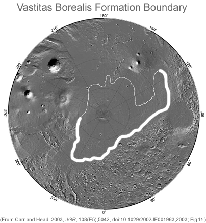
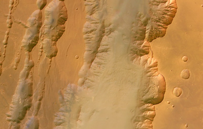