|
![[ image of Mars ]](https://home.csulb.edu/~rodrigue/mars/marsatlas.gif)
|
|
Orders of Relief and the
Regional Geography of Mars
Association of American Geographers
Las Vegas, 26 March 2008
Christine M. Rodrigue
Department of Geography
California State University
Long Beach, CA 90840-1101
1 (562) 985-4895 or -8432
rodrigue@csulb.edu
|
|
Abstract
I taught the first geography of Mars course at California State University,
Long Beach, in Spring 2007. Among its planned student learning outcomes was
student acquisition of a sense of where on Mars features under discussion were
located and their spatial relationships with one another. It became necessary
to create a regional geography scheme for the planet to achieve this. I
adapted the "orders of relief" scheme used in basic geography texts, inherited
from Fenneman's 1916 physiography article. The outcome was a nested five
level scheme. The first order is the divide between the smooth northern
lowlands and the rough southern highlands. The second order comprises the
1,000 km + impact, rifting, volcanic, glacial, and fluvial features. The
third order is that of the terrae and plana that define geological epochs on
Mars, such as Noachis Terra, Hesperia Planum, and Amazonis Planitia. The
fourth order is made up of landscape level features, such as individual
landslides, craters, yardangs, dune fields, drainage systems, and the like.
The fifth order describes the very local features at the scale of the rovers'
and landers' activities, such as trenches, rock abrasion pits, and
"blueberries." The paper will outline the bases for the ordering scheme.
|
|
[ Viewgraph
1 ]
Introduction
I taught the first geography of
Mars course at California State University,
Long Beach, in Spring 2007. How that class came to be was explained in the
Geography of Mars panel earlier in the conference. [ Viewgraph
2 ] In this paper, I will concentrate on one of the student learning
outcomes for that class, which was student acquisition of a mental of Mars
features and their spatial relationships with one another. It became
necessary to create a regional geography scheme for the planet to achieve
this. I adapted the "orders of relief" scheme used in basic geography texts,
inherited from Fenneman's 1916 physiography article. The result was a nested
five level scheme that created a vivid mental map of Mars as a geographical
landscape for the students in the class.
|
|
The First Order of Relief
[ Viewgraph
3 ] All the order of relief schemes in textbook use today agree on the
division of Earth's surface into continents and oceans ( c.f. Bridges
1990; Christopherson 2003; Garrard 1988; and Ritter 2006). On Mars, a
spatially
comparable dichotomy consists of the division into the low elevation northern
third of the planet's surface and the high elevation southern two thirds (MOLA
Science Team 2000). The
Northern Lowlands range from the mean geoid to 5 km below, while the Southern
Highlands typically range from 1 km to 5 km above the mean geoid. [ Viewgraph
4 ]
The
transition between them is quite abrupt, typically forming a 1 km high scarp
(MOLA Science Team 1999).
[ Viewgraph
5 ] The elevation dichotomy coïncides with a contrast in cratering
rates, with the Northern Lowlands having a smooth surface of lava flows and
sediments overlying an ancient cratered terrain. The Southern Highlands are
in most places highly cratered, preserving a record of the age of bombardment
from the time of the planet's accretion to about 3.5 or 3.9 billion years ago.
Lava surfaces in the Northern Highlands are typically andesitic in
composition, while the Southern Highland lavas are predominantly basalts
(Wyatt and McSween 2006). [
Viewgraph
6 ]
The first order
dichotomy is again echoed, though not as perfectly, in differences in crustal
thickness, with the Northern Lowlands quite thin and much of the Southern
Highlands thicker and thickening irregularly towards the South Pole (Zuber
et al. 2000; Science Visualization Studio no date).
The origins of this first order dichotomy remain contentious. The smoothness
and low elevation of the northern lowlands have long suggested sedimentary
deposits, perhaps from an ocean. Tim Parker traced out two sets of
circumboreal shoreline-like features, which remain at least partially credible
under examination of high resolution MOLA data (Parker et al. 1993;
Head et al. 1999: Fig. 1). [ Viewgraph
7 ]
Countering the impression of a primordial ocean/continent dichotomy, however,
are problems both of lithology and of shoreline elevation. On Earth, basalt
dominates the ocean floors, while more highly fractionated igneous rocks, such
as granites and andesites, and their sedimentary and metamorphic derivatives
dominate the continents.
Another problem is the near failure, until recently, to find carbonates, which
the interaction of the carbon dioxide-dominated martian atmosphere with water
could be expected to create in abundance. Late in 2008, however, a layer of
magnesium carbonates was found in association with clays in rock units
dominated by olivines in Nili Fossæ near Isidis Planitia (Ehlmann et
al. 2008). Olivines can be altered into these carbonates in a
non-acidic aqueous environment. The northern ocean idea is, thus, not too
far-fetched.
Whether or not the Northern Lowlands ever contained an ocean, the origins of
the topographic low remain a topic of debate. Among ideas proposed for this
dichotomy are the initiation of one-plume convection with crustal thinning by
ablation
from below and crustal thickening by compression (Roberts and Zhong 2006).
This could have gone so far as mantle overturn by gravitational instability
due to mantle crystalization and reaction placing iron-enriched, denser, and
colder material in the upper mantle (Watters et al. 2007;
Elkins-Tanton et al. 2004). Plate tectonics may have
initiated and, though it did not persist, may have altered the crust in ways
helpful to understanding the dichotomy. Another accounting for the dichotomy
lately gaining support is the idea of a large impact early in Mars' history,
as was known to have happened to the early Earth (Marinova et al. 2008;
Andrews-Hanna et al. 2008). If so, the Northern
Lowlands may simply be the biggest impact crater in the solar system.
[ Viewgraph
8 ]
|
|
The Second Order of Relief
The second order of relief would be the very large planetary features, many of
a scale as to be visible from Earth. They range in size from about 1,000 km
to 8,000 km and include features created by impact, volcanism, rifting,
glaciation, æolian, and fluvial processes. [ Viewgraph
9 ]
Craters
There are four stand-out great craters on Mars: Hellas Planitia, Argyre
Planitia, Isidis Planitia, and Utopia Planitia. These range in size from
~1,500 km in diameter up to 3,300 km. They date to the bombardment of the
Noachian Epoch but to a time after the planetary magnetic field had collapsed
and, therefore, could not "stamp" the (re)solidifying basalts with iron
alignment (Frey et al. 2007).
Volcanic Provinces
Volcanism on Mars, while present in many places, is overwhelmingly
concentrated in two gigantic volcanic rises: Tharsis and Elysium.
Confirmation that Earth-observed albedo features were, in fact, volcanoes and
that they were so stupendously huge was one of the actual shocks provided by
the Mariner 9 orbiter in 1972 as it waited out a planetary dust storm and then
began to image Tharsis' Olympus Mons emerging from the settling dust.
[ Viewgraph
10 ]
Elysium, centered at 25° north lat. and 146° east long., is massive:
some 2,000 km in diameter, rising 5 km above the northern plains, and its
tallest volcano, Elysium Mons, at nearly 13 km in elevation, would dwarf
anything on Earth (Science Visualization Studio 2001). Compared with Tharsis,
however, it becomes relatively
puny.
[ Viewgraph
11 ]
Tharsis, centered along the equator around 245° E. long., spans
roughly 8,000 km and rises roughly 7 km. On its northwest edge lies Olympus
Mons, towering some 27 km above the geoid, and three other gigantic volcanoes
rise in a southwest to northeast line: Arsia Mons, Pavonis Mons, and
Ascræus Mons (MOC 1999; Short no date). There is energetic debate about
the internal forces concentrating magmatic activity in just two major areas
for so long, the
processes enabling the lithosphere to support such massive edifices, the
effects that these volcanic rises have had on Mars, and whether any of their
volcanoes remain active today (Grott 2008).
Rift Zone
[ Viewgraph
12 ]
Valles Marineris proved yet another shock coming from Mariner 9, for which
the feature was eventually named: a system of canyons stretching over 4,000
km just south of the equator (USGS no date). Its individual troughs are
usually about 50 to
200 km wide, though they come together in the center of the formation to form
a feature nearly 700 km wide. In places, Valles Marineris reaches close to 6
km below the geoid, creating local relief of as much as 7-10 km (USGS 2008).
Mechanisms proposed for the origins and development of Valles Marineris are
quite varied. The consensus of the community has largely drifted away from
incipient plate tectonics explanations, though these have gained a cautious
second inspection in light of the possibility that the "missing" transform
faults (Solomon 1978; Golombek 1985) defining a true plate tectonic rift zone
may exist (Connerney et al. 2005). Work over the last couple of
decades
emphasizes extensional rifting associated with the buildup of Tharsis (Schultz
1991),
landsliding (Montgomery et al. 2009), subsidence associated with
subterranean removal of fluids (Tanaka and Golombek 1989; Rodríguez
et al. 2006), and
debate about the nature and geomorphic effects of such candidate fluids as
magma (Schonfeld 1979), water, brine, carbon dioxide (Hoffman 2000), or magma
intrusions as they affect subterranean fluids or ices (McKenzie and Nimmo
1999).
The Polar Ice Caps
[ Viewgraph
13 ]
The smallest but arguably the most conspicuous and variable of the second
order relief landforms are the two polar ice caps. These became visible from
Earth with the earliest telescopes.
In terms of composition, the North Polar Cap is mainly composed of water ice,
which dominates the residual ice that persists through all seasons. Carbon
dioxide will sublime as frost out of the atmosphere whenever temperatures drop
below 150 K, so winter in the northern hemisphere results in the development
of a carbon dioxide veneer on top of the water ice core of the North Polar Cap
(Zuber et al. 1998: 2055). During summer, the carbon dioxide sublimates into
vapor and then the water ice exposed below it does the same, shrinking the ice
cap noticeably.
The residual South Polar Cap is considerably smaller than the North Polar Cap
at roughly 350 km diameter, versus ~1,000 km, respectively (Boyce 2002: 187).
As with the North Polar Cap, the South Polar Cap expands with winter, to
roughly -45° lat., and shrinks in summer. The South Polar Cap has until
recently been believed to be completely different in composition from the
North Polar Cap because of its elevation 6 km higher than its northern
counterpart (Albee 2000). Carbon dioxide ice mantles the
South Polar Ice cap year round, but it has recently been established that
water ice lies below the carbon dioxide ice surface at 8 m in depth (Byrne and
Ingersoll 2003; Kieffer et al. 2006).
Syrtis Major
[ Viewgraph
14 ]
Wind is the process responsible for exposing the large, roughly triangular
area of dark basalt in Syrtis Major. This feature, the "blue scorpion," was
the first martian landform recorded in a sketch map drawn by Christiaan
Huygens in 1659 (and, debatably, as early as 1636 by Francisco Fontana). The
shape of the Syrtis Major dark areas change over time, which was the basis for
early speculations about Mars having vegetation that responded to seasonality.
Wind moves light colored dust over the borders of the Syrtis region but keeps
its core essentially swept clean, exposing the dark basalts (Mustard et
al. 1993).
The Chryse Trough
A large arc of locally depressed topography loosely rings the Tharsis Rise,
most likely the result of the loading of lava on the lithosphere below the
Tharsis volcanoes. This effect is particularly obvious to the east of Tharsis
and to the west of the annular ejecta ringing Hellas Planitia, punctuated by
the great Argyre Planitia basin. Timothy Parker in 1985 suggested that this
depression east of Tharsis, dubbed the Chryse Trough, might have housed an
actual channel for catastrophic flooding, comprising several tributary
channels flowing from near the South Polar Ice Cap into Argyre. From a
presumed lake in Argyre, the flow would move through Uzboi Vallis into a chain
of smaller craters linked by channels that flowed into Margaritifer Terra east
of Valles Marineris. From there, drainage would move into Chryse Planitia and
the presumed northern lowlands ocean (Parker 1985, cited in Parker et
al.
2003). The Mars Orbiter Laser Altimeter (MOLA), Mars Orbital Camera (MOC)
instruments, and the Thermal Emission Spectrometer (THEMIS) have provided
high resolution topographical information that does seem to confirm the
existence of an 8,000 km drainage system (Parker et al. 2003), though
not without criticism in one
or another segment of the proposed system ( e.g., Hiesinger et
al. 2007). If, in fact, this system did move
water or other fluids from the area around the South Polar Cap to Chryse
Planitia, even as a sporadic and perhaps not always continuously connected
drainage, at some 8,000 km in length, the Chryse Trough would constitute the
longest fluvial network in the solar system.
|
|
The Third Order of Relief
The third order marks broad regions (terræ, plana, and planitiæ)
[ Viewgraph
16 ] differentiated largely by crater density and, thus, relative age. I
used this level of the hierarchy to present the tripartite epochs dividing
Mars' geologic history. The Noachian Epoch dates from planetary
formation to somewhere between 3.9 and 3.5 billion years ago (Hartmann 2004;
Golombek 2006). This was a time
of repeated and often substantial impacts, sometimes referred to as the "age
of bombardment." This was also the time when the planet had a magnetic field
and a denser atmosphere and, thus, the time when liquid water was most likely
to have formed fluvial networks and pooled on the surface of the planet
(Hartmann 2003: Part II). The early part of the Noachian (to about 4 billion
years ago) thus generated phyllosilicate clay geochemistry (Bibring et
al. 2006). Some
of the buildup of Tharsis goes back to this epoch.
[ Viewgraph
17 ] Noachian landscapes include Noachis Terra, Arabia Terra, Sirenum
Terra, and Terra Cimmeria.
[ Viewgraph
18 ] The Hesperian Epoch runs from the end of the "age of
bombardment" 3.9 to 3.5 billion years ago in some usages to 3.5 to 1.8 billion
years ago in others (Hartmann 2004), a time of extensive volcanic flows,
dominance by sulfate surface chemistry (Bibring et al. 2006), loss of
the bulk of
the planet's atmosphere and surface water, desiccation and freezing, and
possibly some sudden and truly massive outflows of subterranean water or other
fluids.
[ Viewgraph
19 ] It includes such regions as Hesperia Planum, Terra Tyrrhena, Aonia
Terra, Margaritifer Terra, and Gusev Crater.
[ Viewgraph
20 ] The Amazonian Epoch is "modern" Mars, dating back 1.8
billion years or as much as 3.5 billion years (Hartmann 2004). This is a time
in which the
dominant geomorphic processes seem to be æolian, though there are
tantalizing
hints of volcanic eruptions and outflows, mass wasting, glacial, and fluvial
activity perhaps driven by groundwater eruptions or seeps. Surface alteration
transitions to dominance by anhydrous ferric oxides (Bibring et al.
2006).
[ Viewgraph
21 ] These would include the landscapes of Amazonis Planitia, Chryse
Planitia, Acidalia Planitia, and Utopia Planitia.
|
|
The Fourth Order of Relief
The fourth order is made up of smaller features, "landscape" scale features.
[ Viewgraph
22 ] Nearly ubiquitous at this scale, if spatially varying in density,
are the impact features: craters at every size, level of modification,
and degree of superposition. There are pristine, bowl-shaped craters with
sharp rims, such as Zunil Crater [ Mars Odyssey THEMIS ] and craters so new
they still have debris blown around them, such as this one in Arabia Terra
that formed between April 2001 and December 2003 [ MGS MOC ]). There are
craters perched on top of pedestals or ramparts of their own consolidated
ejecta blankets, which then become elevated above the landscape as erosion
removes materials around them, as seen on the frozen plains of Acidalia
Planitia [MGS MOC ]. There are craters with erosion-softened edges and floors
nearly flat with lava, sedimentary, glacial, snow, or æolian fill, such
as
this glaciated pair of craters on the east side of Hellas Planitia [ HRSC ],
the snow-covered Udzha Crater near the North Polar Cap [ Mars Odyssey THEMIS
], Victoria Crater (made famous by the Opportunity Rover's activities) with
its dunes [ MRO HiRISE ], and the seemingly sedimentary fill in Schiaparelli
Crater since etched out by the wind [ MGS MOC ]. Many craters are completely
buried by newer surfaces, as revealed by these subsurface radar soundings by
the Mars Express MARSIS sensor.
[ Viewgraph
23 ] Some of the fourth order landscape features are tectonic in
origin, such as the huge volcanic montes (e.g., Olympus Mons [ Viking ]) and
smaller tholi (e.g., Uranius Tholi, Tharsis [Viking ]), landscapes criss-
crossed by what look like lava tubes (e.g.,Pavonis Mons' south slope [ HRSC
]), and lava flows themselves (e.g., in this partially buried crater in the
area between Dadalia Planum and Terra Sirenum [MGS MOC ]. Faulting is
suggested by the fossa or graben-like structures that may indicate tensional
stress and failure or, alternatively, the loss of surface support as
subterranean lavas or other fluids are extracted (e.g., Claritas
Fossæ along
the Thaumasia Montes boundary with Solis Planum [ HRSC ] and Cerberus
Fossæ
southeast of Elysium Planitia [ MRO HiRISE ]). There is, however, very little
if, arguably, any folding and faulting like those associated with Earth plate
tectonics. A possible exception is the Thaumasia Montes, which look the part
(Anguita et al.)
and may represent an area of incipient and stalled subduction [ map from
Technische Universität Berlin using MOLA ].
[ Viewgraph
24 ] The fourth order landscapes include such fluvial features as
deltas (e.g., Eberswalde Delta in Eberswalde Crater in the northeast of Holden
Crater, in the second order fluvial system [MGS MOC]), valles that look like
fluvial networks (e.g., Ma'adim Vallis, seeming to debouche into Gusev Crater
and a dendritic network on the Southern Highlands [ Viking ]), and gullies in
the walls of south polar pits that resemble sapping outflow features on Devon
Island in the Canadian Arctic [MGS MOC]).
[ Viewgraph
25 ] Massive fluvial outflow events , or jökulhlaups, are
evident in several places on Mars, particularly to the east and west of the
Tharsis Rise. These entail sudden flows of volumes of water one or two
magnitudes beyond the Missoula Flood events that created the channelled
scablands of eastern Washington at the Pleistocene-Holocene boundary. Valles
Marineris may have experienced these (though the "mouth" is at higher
elevation than the middle of the system), as did Kasei Vallis [ MOLA map ],
Athabasca Vallis [ MRO HiRISE ], Ganges Chasma [ Mars Odyssey THEMIS ],
Nanedi Vallis, Ares Vallis, Uzboi Vallis, and dozens of others.
[ Viewgraph
26 ] Fourth order landscapes include features evocative of
coastal processes, which were the basis for Tim Parker's delineation of
two marine stands in the Northern Lowlands. At the fourth order level, these
include step-like slopes on the north side of Alba Patera that suggest wave
cut benches and wave built terraces. Also evoking a coastal impression are
all the fluvial and outflow channels that seem to discharge into the Northern
Lowlands, especially in and around Chryse Planitia.
[ Viewgraph
27 ] Other fourth order features reflect mass wasting on a grand
scale, including landslides (e.g., Noctis Labyrinthus [ Mars Odyssey THEMIS ]
and Aram Chaos [Mars Express HRSC]) and avalanches (e.g., the North Polar ice
cap [MRO HiRISE]). The landslides may be responsible for the formation of
chaos terrain, which looks like large blocks tumbled down from the extraction
of subterranean support, perhaps the sudden liberation of warm water when ice
faces fail, volcanic heating of permafrost or groundwater or even frozen
carbon dioxide. Chaos terrains are often implicated as the source of the
jökulhlaup outflows.
[ Viewgraph
28 ] Another type of fourth order landscape is dominated by
æolian processes. Mars is, for the most part, an amazingly dusty
place, with the wind homogenizing the chemical composition of the dust by
distributing it nearly everywhere, sometimes in world-engulfing duststorms.
Wind appears to have dominated the surface of Mars to the extent that fluvial
processes dominate on Earth. There are landscapes of wind erosion, such as
the second order feature Syrtis Major already mentioned. At the fourth order
level, there are large expanses of yardangs, such as in Æolis
Mensæ [ MGS MOC
] or an area south of Olympus Mons in the transition to Amazonis Planitia [
HRSC ]. In many areas, sandblasting appears to be sequentially exposing and
etching out layers of volcanic or fluvial origin, creating complex "contour
map" terrain, such as here in far southwestern Candor Chasma. Sand deposition
is also abundantly in evidence, with landscapes dominated by dunes, such as
these barchans in Nili Patera [ MGS MOC ], in Endurance Crater [ MER Opp
PanCam ], and this field trapped in the bottom of a crater in northwest
Argyre Planitia [ HRSC ].
[ Viewgraph
29 ] Fourth order landscapes also include glacial and periglacial
phenomena at a smaller scale than the second order ice caps. Small glaciers
have been found in craters, such as this one in Vastitas Borealis [ HRSC ],
and the ice caps themselves present exposures of layers along their edges,
sometimes showing glacio-fluvial features, such as the channels seen in this
landscape in Planum Boreum near Olympia Undae under and adjacent to the
residual ice cap [MRO HiRISE ]. There are periglacial features, too, such as
polygon-patterned land, as here in Acidalia Planitia [ MGS MOC ] and at the
tiny scale of the Phoenix landing site [ Phoenix ].
[ Viewgraph
30 ] There are also glacial geyser features that particularly
affect the South Polar Cap. As spring approaches, some of the carbon dioxide
that forms the upper 8 meters of the cap begins to sublimate explosively,
blasting through layers of carbon dioxide ice and dust layers, taking some of
the dust with it. This creates a distinctive pitted landscape, often
accompanied by spider-like patterns of dust deposits around the pits.
|
|
The Fifth Order of Relief
[ Viewgraph
31 ]
The fifth order of relief describes the small features and contrasts typically
seen at the scale of the rovers' and landers' activities, but sometimes also
from orbit-borne high-resolution sensors: individual boulders and rocks,
frost deposits on them and on the ground, dust devil tracks, light-toned new
gully flows and deposits, sand and dust streaks, the small-scale
"blueberries," and "RAT holes" from the rovers' Rock Abrasion Tools.
|
|
Conclusion
To conclude, I believe Mars and other extraterrestrial objects are within the
purview of geography, geographers can contribute meaningfully to Mars
research, and the study of Mars can benefit geography. Involvement with Mars
research could increase activity in æolian process research, which is
relatively underdeveloped in physical geography today compared with fluvial or
glacial geomorphology. Mars research and geographers can definitely benefit
from the field-based analogues of Earth landscapes that can be used to
generate hypotheses for testing with Mars data (Bishop 2009). Mars can be
used to deepen Earth understanding among our students through the compare and
contrast it affords. It is in the spirit of sparking this conversation that I
offer this application of a canonical geographical idea: the Martian orders
of relief.
|
|
References
Albee, A. 2000. Mars 2000. Annual Reviews of Earth and Planetary
Sciences 28: 281-304. doi:10.1146/annurev.earth.28.1.281
Andrews-Hanna, J.C.; Zuber, M.T.; and Banerdt, W.B. 2008. The Borealis basin
and the origin of the martial crustal dichotomy. Nature 453: 1212-1216.
doi: 10.1038/nature07011. Available at http://library.mines.edu/~jcahanna/AndrewsHanna_Nature_2008.pdf.
Anguita, F.; Fernández, C.; Cordero, G.; Carrasquilla, S.; Anguita, J.;
Núñez, A.; Rodríguez, S.; and García, J. 2006.
Evidences for a Noachian-Hesperian orogeny on Mars. Icarus 185: 331-
357. doi: 10.1016/j.icarus.2006.07.026.
Bibring, J-P.; Langevin, Y.; Mustard, J.F.; Poulet, F.; Arvidson, R.; Gendrin,
A.; Gondet, B.; Mangold, N.; Pinet, P.; Forget, F.; and the OMEGA Team. 2006.
Global mineralogical and aqueous Mars history derived from OMEGA/Mars Express
data. Science 312: 400-404. doi: 10.1126/science.1122659.
Bishop, Mark. 2009. Mars (planetary) geography. Panel presentation to the
Geography of Mars special session, Association of American Geographers, Las
Vegas (March).
Bridges, E.M. 1990. World Geomorphology. Cambridge University Press.
Byrne, S. and Ingersoll, A.P. 2003. A sublimation model for martian south
polar ice features. Science 299: 1051-1053. doi:
10.1126/science.1080148
Christopherson, R.W. 2003. Geosystems: An Introduction to Physical
Geography, 5th ed. Prentice Hall.
Ehlmann, B.; Mustard, J.F.; Murchie, S.L.; Poulet, F.; Bishop, J.L.; Brown,
A.J.; Calvin, W.M.; Clark, R.N.; Des Marais, D.J.; Milliken, R.E.; Roach,
L.H.; Roush, T.L.; Swayze, G.A.; and Wray, J.J. 2008. Orbital identification
of carbonate-bearing rocks on Mars. Science 322, 5909 (19 December):
1828-1832. doi: 10.1126/science.1164759.
Elkins-Tanton, L.T.; Zaranek, S.E.; and Parmentier, E.M. 2004. Magma ocean
cumulate overturn: Generation of an early magnetic field. Second Conference
on Early Mars, Jackson Hole, WY (11-15 October). Available at http://www.lpi.usra.edu/meetings/earlymars2004/pdf/8034.pdf
Fenneman, N. 1916. Physiographic subdivision of the United States. Annals
of the Association of American Geographers 6: 19-98.
Frey, H.; Edgar, L.; and Lillis, R. 2007. Very large visible and buried
impact basins on Mars: Implications for internal and crustal evolution and the
late heavy bombardment in the inner solar
system. Seventh International Mars Conference, Pasadena, CA (9-13 July).
Available at .
Garrard, A.J. 1988. Rocks and Landforms. Routledge.
Golombek, M. 2006. Surficial geology of the Sprit Rover traverse
in Gusev Crater: Dry and desiccating since the Hesperian. Graph and lecture
available at http://www.aics-
research.com/lotw/lotw20060626.html
Grott, M. 2008. Is Mars geodynamically dead? Science 320: 1171-1172.
doi: 10.1126/science.1159365.
Hartmann, W.K. 2003. A Traveler's Guide to Mars: The Mysterious Landscapes
of the Red Planet. Workman Publishing.
Hartmann, W.K. 2004. Isochrons for martian crater populations of various
ages. Planetary Science Institute, Tucson, AZ. Available at http://www.psi.edu/projects/mgs/chron04a.html.
Head, J.W.; Heisinger, H.; Ivanov, M.A.;Kreslavsky,M.A.; Pratt, S.; and
Thomson, B.J. 1999. Possible ancient oceans on Mars: Evidence from Mars
Orbiter Laser Altimeter data. Science 286: 2134-2137. Available at http://mars.jpl.nasa.gov/mgs/sci/mola/dec10-
99rel/ocean_paper.html.
Hiesinger, H.; Kuhlmann, J.; Reiss, D.; Scholten, F.; and Neukum, G. 2007.
Geologic-hydrologic investigation of Uzboi Vallis and northern Argyre Basin.
Presentation at European Planetary Science Congress, Potsdam, Germany (20-24
August). Available at http://www.cosis.net/abstracts/EPSC2007/00350/EPSC2007-A-00350.pdf?PHPSESSID=0eae07179dd7edaa23d465039bb79f93.
Hoffman, N. 2000. White Mars. A new model for Mars' surface and atmosphere
based on CO2. Icarus 146: 326-342.
doi:10.1006/icar.2000.6398
Kieffer, Hugh H.; Christensen, Philip R.; Titus, Timothy N. 2006.
CO2 jets formed by sublimation beneath translucent slab ice in
Mars' seasonal south polar ice cap. Nature 442: 793-796. doi:
10.1038/nature04945.
Mckenzie, D. and Nimmo, F. 1999. The generation of Martian floods by the
melting of ground ice above dykes. Nature 397: 231-233. Available at http://www.es.ucsc.edu/~fnimmo/website/paper9.pdf.
Marinova, M.M.; Aharonson, O.; and Asphaug, E. 2008. Mega-impact formation of
the Mars hemispheric dichtomy. Nature 453: 1216-1219. doi:
10.1038/nature07070. Available at http://www.gps.caltech.edu/~oa/publications/marinova2008_nature.pdf.
MOC. 1999. Afternoon clouds over the Tharsis volcanoes and Valles Marineris
in April 1999 (Mars Orbiter Camera image courtesy of NASA/JPL/Malin Space
Science Systems). Mars Global Surveyor orbiter, MOC2-144. Available at http://nova.stanford.edu/projects/mgs/dmwr.html.
MOLA Science Team. 1999. Mars Orbiter Laser Altimeter profiles of Mars
topography by polar orbit, first presented at the Lunar and Planetary Science
Conference, Houston, TX (March 16) by the MOLA Science Team, Goddard Space
Flight Center.
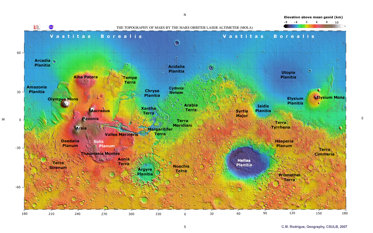
MOLA Science Team. 2000. Mars Orbiter Laser Altimeter topographical map,
Mercator projection, MOLA Science Team, Goddard Space Flight Center. Available
at http://mola.gsfc.nasa.gov/images.html.
Annotated with place name labels by C.M. Rodrigue and available at: https://home.csulb.edu/~rodrigue/mars/MOLAmercatorlabel.jpg
Montgomery, D.R.; Som, S.M.; Jackson, M.P.A.; Schreiber, B.C.; Gillespie,
A.R.; and Adams, J.B. 2009. Continental-scale salt tectonics on Mars and the
origin of Valles Marineris and associated outflow channels. The Geological
Society of America Bulletin 121: 117-133. doi: 10.1130/B26307.1.
Mustard, J.F.; Erard, S.; Bibring, J-P; Head, J.W.; Hurtrez, S.; Langevin, Y.;
Pieters, C.M.; and Sotin, C.J. 1003. The surface of Syrtis Major:
Composition of the volcanic substrate and mixing with altered dust and soil.
Journal of Geophysical Research 98, E2: 3387-3400. Available at http://www.planetary.brown.edu/pdfs/1298.pdf.
Parker, T.J.; Gorsline, D.S.; Saunders, R.S.; Pieri, D.C.; and Schneeberger,
D.M. 1993. Coastal geomorphology of the Martian northern plains. Journal
of Geophysical Research 98: 11,061-11,078.
Parker, T. J.; Grant, J. A.; Anderson, F. S.; and Banerdt, W. B. 2003.
From the south pole to the northern plains: The Argyre Planitia story. Sixth
International Conference on Mars, Pasadena, CA (20-25 July). Available at http://www.lpi.usra.edu/meetings/sixthmars2003/pdf/3274.pdf.
Ritter, M.E. 2006. Earth materials and structure: Orders of relief. In The
Physical Environment: An Introduction to Physical Geography. Online
textbook available at http://www.uwsp.edu/geo/faculty/ritter/geog101/textbook/earth_materials_structure/orders_of_relief.html
Roberts, J.H. and Zhong, S. 2006. Degree-1 convection in the Martian mantle
and the origin of the hemispheric dichotomy. Journal of Geophysical
Research 111: E06013. doi:10.1029/2005JE002668.
Rodríguez, J.A.P.; Kargel, Jl; Crown, D.A.; Bleamaster, L.F., III;
Tanaka, K.L.; Baker, V.; Miyamoto, H.; Cohm, J.M.; Sasaki, S.; and Komatsu, G.
2006. Headward growth of chasmata by volatile outburts, collapse, and
drainage: Evidence from Ganges chaos, Mars. Geophysical Research
Letters 33: L18203. doi: 10.1029/2006GL026275.
Science Visualization Studio. No date given. Mars crustal thickness, Mars
Global Surveyor, MOLA. Science Visualization Studio, Goddard Space Flight
Center, NASA. Available at http://svs.gsfc.nasa.gov/goto?1105.
Science Visualization Studio. 2001. Mars MOLA false color image of Elysium
Mons looking south to north (vertical exaggeration 3x, shading 6x). Available
at http://svs.gsfc.nasa.gov/goto?2326.
Schultz, R.A. 1991. Structural development of Coprates Chasma and western
Ophir Planus, Valles Marineris Rift, Mars. Journal of Geophysical
Research 96: 22,777-22,792. doi: 10.1029/91JE02556.
Short, N.M., Jr. No date given. Olympus Mons and its three Tharsis
companions on a map of the United States. Remote sensing tutorial. Martian
landscapes: Linear features, volcanoes, impact craters, channels, exotic
terrains. Section 19, Chapter 12. Available at http://rst.gsfc.nasa.gov/Sect19/Sect19_12.html
Tanaka, K.L., and Golombek, M.P. 1989. Martian tension features and the
formation of grabens and collapse features at Valles Marineris.
Proceedings of the 19th Lunar and Planetary Science Conference 19: 383-
396. Available through .
USGS. No date given. Valles Marineris. Mosaic of 102 Viking Orbiter images
projected onto point perspective. Astrogeology Research Program, U.S.
Geological Survey, U.S. Department of the Interior. Available at http://astrogeology.usgs.gov/Projects/MarsHemispheres/.
USGS. 2008. Valles Marineris: The Grand Canyon of Mars. Astrogeology
Research Program, U.S. Geological Survey, U.S. Department of the Interior.
Available at http://astrogeology.usgs.gov/Projects/VallesMarineris/.
Watters, T.R.; McGovern, P.J.; and Irwin, R.P., III. 2007. Hemispheres
apart: The crustal dichotomy on Mars. Annual Review of Earth and
Planetary Science 35: 621-652. doi:
10.1146/annurev.earth.35.031306.140220
Wyatt, M.B. and McSween, H.Y., Jr. 2006. The orbital search for altered
materials on Mars. Elements 2: 145-150. doi:
10.2113/gselements.2.3.145
Zuber, M.T.; Smith, D.E.; Solomon, S.C.; Abshire, J.B.; Azfal, R.S.;
Aharonson, O; Fishbaugh, K.; Ford, P.G.; Frey, H.V.; Garvin, J.B.; Head, J.W.;
Ivanov, A.B.; Johnson, C.L.; Muhleman, D.O.; Neumann, G.A.; Pettengill, G.H.;
Phillips, R.G.; Sun, X.; Zwally, H. J.; Banerdt, W. B.; and Duxbury, T.C.
1998. Observations of the north polar region of Mars from the Mars Orbiter
Laser Altimeter. Science 282, 5396 (11 December): 2053-2060. doi:
10.1126/science.282.5396.2053
Zuber, M.T.; Solomon, S.C. ; Phillips, R.J.;. Smith, D.E;. Tyler, G. L.;
Aharonson, O.; Balmino, G.; Banerdt, W.B.; Head, J.W.; Johnson, C.L.;
Lemoine, F.G.; McGovern, P.J.; Neumann, G.A.; Rowlands, D.D.; and Zhong,
S. 2000. Internal structure and early thermal evolution of Mars from Mars
Global Surveyor topography and gravity. Science 287: 1788-1793.
doi:10.1126/science.287.5449.1788
|
|
|
This document is maintained by C.M.
Rodrigue
First placed on web 03/26/09
Last Updated: 04/04/09
|