Description of the Events
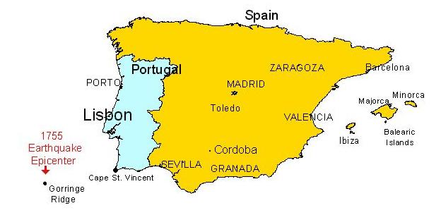
The earthquake began at 9:30 AM on November 1st, 1755, and was centered in the Atlantic Ocean, about 200 km WSW of Cape St. Vincent, southwest of Europe. The total duration of shaking lasted ten minutes and was comprised of three distinct jolts. Effects from the earthquake were far reaching. The worst damage occurred in the southwest of Portugal. Lisbon, the Portuguese capital, was the largest and the most important of the cities damaged. Severe shaking was felt in North Africa and there was heavy loss of life in Fez and Mequinez. Moderate damage was done in Algiers and in southwest Spain. Shaking was also felt in France, Switzerland, and Northern Italy. A devastating fire following the earthquake destroyed a large part of Lisbon, and a very strong tsunami caused heavy destruction along the coasts of Portugal, southwest Spain and western Morocco.
The oscillations of suspended objects at great distances from the epicenter indicate an enormous area of perceptibility. The observations of the resulting waves as far away as Finland suggest a magnitude approaching 9.0. Precursory phenomena were reported, including turbid waters in Portugal and Spain, falling water level in wells in Spain and a decrease in water flow in springs and fountains.
Lisbon was not only a city of 250,000 people but also the capital of the Portuguese empire, which spread around the world. It was the 4th largest city in Europe, at the time, and one of the most important. Although Portugal had been hit by quakes in the past, it had been 200 years since the last major earthquake. The quake hit at 9:30 AM on All Souls Day. Many buildings collapsed burying those inside and on the street, outside.
The quake triggered a tsunami, which arrived soon afterwards. As usual, the first indication was that the water drew back from the land. Soon, however, the water came back with a wave estimated at 65 feet high crashing through the city. Ships, docks and buildings in the city were battered by the high seas. Thousands were swept away.
The Fire
Soon after the earthquake, several fires broke out, mostly started by cooking fires and candles. Some of them were rapidly extinguished, especially in the densely populated areas. But many inhabitants fled from their homes and left fires burning. Narrow streets full of fallen debris prevented access to the fire sites. The public squares filled with people and their rescued belongings, but as the fire approached, these squares were abandoned, and the fire reached catastrophic proportions. Looters setting fire to some ransacked houses caused the belief that the fire had a criminal origin. The flames raged for five days.
All of the downtown area, from St. Paul's quarter to St. Roch, and from Carmo and Trindade to the Rossio square area to the Castle and Alfama quarters were burned, along with the Ribeira, Rua Nova, and Rossio quarters. Remolares, Barrio Alto, Limoeiro, and Alfama, were partially burned. The fire destroyed several buildings, which had suffered little damage due to the earthquake. The Royal Palace and the Opera House were totally gutted by the flames. The Patriarchal suffered relatively little damage in the earthquake, and religious services continued there during the afternoon, but the church was evacuated as the fire approached. Later the building was completely burned out.
The Tsunami
Immediately after the earthquake, many inhabitants of Lisbon looked for safety on the sea by boarding ships moored on the Tagus River. Unfortunately, about a half-hour later, the first of the waves hit and is described in the section about the tsunami.
Earthquake Depictions
The pictorial material related to the 1755 Lisbon earthquake is extensive and broadly distributed. It includes factual renderings of the actual events, as well as fanciful interpretations. The latter, which tend to exaggerate the disaster, are most often found in rural regions. In general, it can be said that the degree of accuracy in these materials decreases in proportion to increases in distance from Lisbon and the time elapsed after the earthquake. Some examples contain both accurate and fanciful material.
Accurate Depictions
Pictures that accurately depict the events of November 1st, 1755 are few. Among the best of these are a series of six excellent engravings by Le Bas. These were based on drawings made by Paris and Pedegache, who were in Lisbon at the time of the earthquake. The final compositions, which appear in several printed series, are characterized by a photographic-like accuracy. They show the damage caused to St. Roch Tower, St. Paul's Church, the Cathedral, the Opera House, St. Nicholas Church and to the Patriarchal. The size of the vegetation growing on top of the ruins in these pictures indicates that they were probably created late in 1757. Four of these original drawings survived and are on display in the City Museum of Lisbon.
One version of this series contains legends written mainly in English. The text of this version, which retains some subtitles in Portuguese and French, notes that the depiction is of the ruins "immediately after the earthquake." The bushes and trees on the ruins, however, are the same as in the pictures with the Portuguese/French legend dated 1757. The text in the English version mentions the names of Paris and Pedegache. It is difficult to decide which series was made earlier.
Of the several reproductions of the six Paris and Pedegache drawings printed from copper engravings, one series contains Portuguese and French text numbered 1-6 in Arabic numerals (an example is on display at the City Museum, Lisbon). The same series with Roman numbering is located in the National Library, Paris. There is also an unnumbered series with English captions, also kept at the National Library, Paris, and several series done in color, one of which has English captions and is kept in the City Museum, Lisbon, probably printed in the 19th century. One unnumbered depiction shows the damaged Patriarchal Square, engraved by Prattent for Barlow's book General History of Europe. Le Bas compositions were copied many times in the course of the 18th and 19th centuries. These copies are marked by descending quality and accuracy.
The Le Bas series represents the first instance of exact and systematic documentation of damage caused by an earthquake. Only 28 years later, this method was enriched and improved by F. Schiantarelli, who, together with his colleagues, created 68 excellent engravings of the 1783 Calabria (Italy) earthquake.
Fanciful Depictions
The Lisbon quake was redrawn, often in a fanciful manner, for many years throughout Europe. Chronologically, these depictions can be split into three groups. The first group was made immediately after the event, between 1755 and 1757. The second series is from the 18th century. The last are the illustrations for scientific or religious purposes of the 19th and early 20th centuries. Figures 13 through 21 are described in detail under the section, entitled, "Art and Fanciful Depictions" from the 18th, 19th and 20th Century.
CLICK LINKS FOR OTHER MODULES
![]()
![]()
![]()
![]()
![]()


![]()
![]()
![]()
![]()