GEOG 442 Group Project: Palos Verdes
Biogeography

Team:
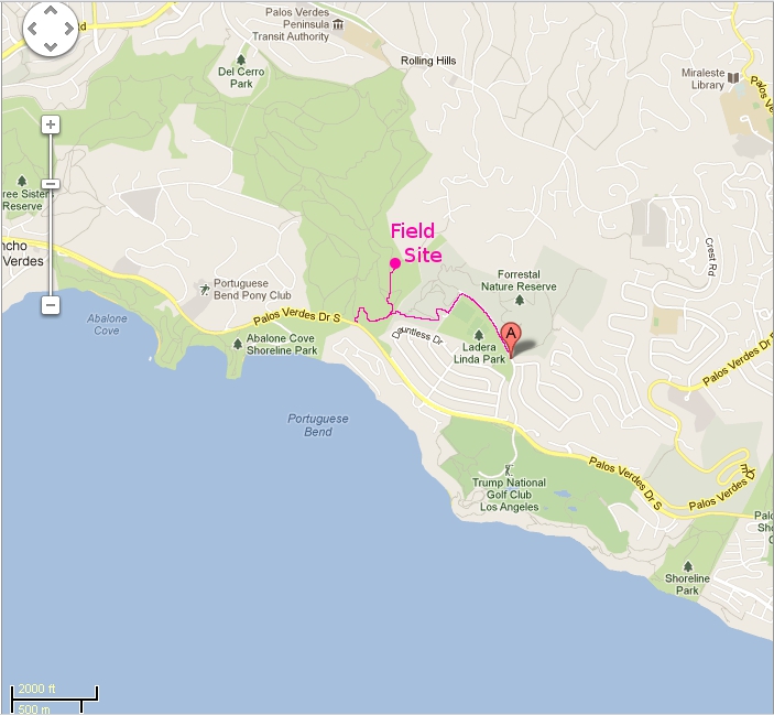
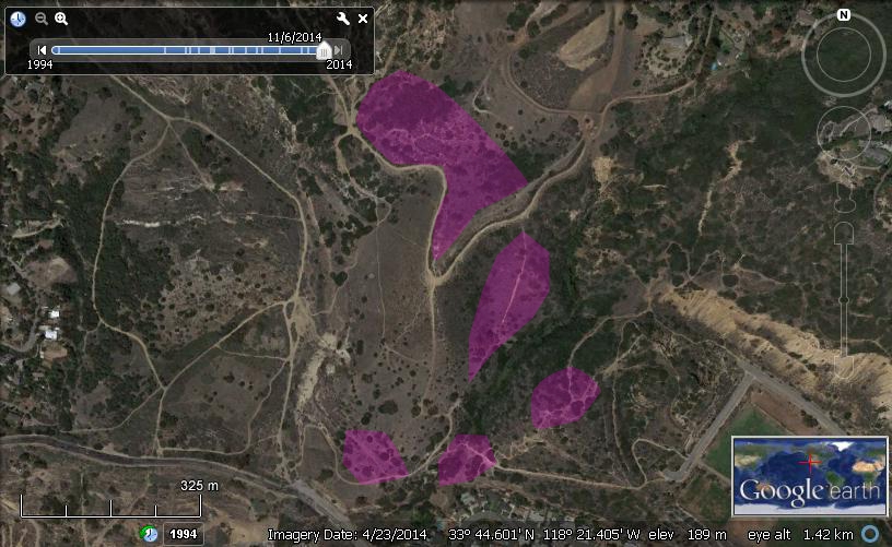
The Palos Verdes Peninsula has a long history of disturbance, from the cattle rancho of Juan José Dominguez in 1784, the fruit and vegetable plots of Japanese farmers beginning in the early 1900s, and the suburbanization of the Peninsula. CSS was close to obliterated in much of the peninsula and has been the target of restoration efforts, ranging from the intense gardening of the Trump Golf Course through active restoration at White Points and in Peacock Flats Valley to passive self-restoration here and there. I'd like you to transect some sites that look as though CSS is expanding on its own, which are located farther down Crenshaw Extension/Burma Road than we got to during the class field trip.
Probably the best way to get to the field sites is to park on Palos Verdes Drive South, looking for a parking area on the north side of the road not quite a half mile west of Schooner Dr. From there, you can access a trail that leads up into the Portuguese Bend Reserve. At the first fork, bear right onto the Klondike Canyon Trail. One of the sites is not far up that trail. At the intersection with Conqueror Trail, go right. You can climb up the switchback Dauntless Trail when you cross the canyon or continue a way along Conqueror to Cactus Trail and take that left up the hill, making a right at Dauntless and transecting on the hill there.
Trotting back down to the Klondike Trail, take it north to the Klondike Canyon Creek Trail and ride that up the hill on the other side of the canyon, transecting along the ridge the trail follows. The trail ends at the Burma Road Trail (aka Crenshaw Extension). Here is where you'll do beaucoup transecting. Make a left onto Burma and follow it around a long bend, almost a switchback, until you see a small informal trail on the right that leads into the study site. This area features some stable lemonadeberry on the left and some on the right, along with other, lower CSS plants. The area right between them has quite a disturbance history with grass/mustard and CSS going back and forth over the site. You're pretty close to the boundary of the Reserve, so try not to cross onto private land, if you see a fence or other demarcation.
Here're the data to gather from transects taken in or beside actual CSS (try to avoid grassy areas). Some of your transects can be done from the trail's edge, where you would identify the shrubs beside the transect tape. Others you'll need to get in among the shrubbery, and, so, you'd identify the shrubs below the transect tape marks.
Here are a few coördinates of what look like various types of CSS:
Make sure to review the plants you're likely to find there and bookmark the PV key on your smartphones:
There are a few great pizza places in San Pedro along Gaffey Street, which I stumbled on after scoping out field trips. If you're wiped out after the field rigors, you might enjoy Bonello's New York Pizza at 832 South Gaffey.