|
Lecture Notes for the Midterm
First order of relief: Features covering at least a quarter of the
planetary surface
- The great crustal dichotomy
- See Viewgraphs: "First order: Crustal dichotomy."
- If Earth's oceans evaporated, which they
one day will, there would remain a crustal dichotomy.
- The former ocean basins would show as low-elevation areas of thinner
crust, dominated by the heavy, dense, dark basalts, in many places covered
with a relatively smooth veneer of continent-derived (terrigenous) sediments
and pelagic sediments (siliceous and calcareous oozes from [former] ocean life
and clays).
- The former continents would show up as raised areas of thick crust, with
materials derived from the lighter granites (e.g., granite, andesite,
rhyolite; the alluvial and nearshore marine sediments derived from them, such
as shale, sandstone, and limestone; and the metamorphosed rocks deriving
fromany of these, such as slate, quartzite, and marble)
- So, too, on Mars, we see a crustal dichotomy: the northern lowlands and
the southern uplands that evokes the future appearance of our own planet
(something to "look forward to"!)
-
The Northern
Lowlands is the low, smooth northern third of the planet:
- Overview of some of its (mostly third order) regional subdivisions (we'll
go over each of these later in the semester):
- Vastitas Borealis, the low expanse surrounding the North Polar Ice Cap
and comprising the bulk of the Northern Lowlands
- Utopia Planitia, northwest of the Elysium volcanic rise: Huge crater
- Embayments:
- Elysium Planitia east and southeast of the Elysium volcanic rise
- Isidis, east of Arabia Terra and between Utopia and Hellas, an impact
basin
- Acidalia Planitia, north of Arabia Terra
- Chryse Planitia, southwest of Acidalia and north of the eastern outflows
of the Valles Marineris system, which flow into it
- Arcadia Planitia, north and west of Alba Mons/Tharsis
- Amazonis Planitia, west of Olympus Mons
- Overall, the Northern Lowlands terrain is a relatively young
surface:
few craters, a relatively smooth and flat to very gently sloping surface
- This is what you would expect if an ocean (?!) had existed there
and received
sediments from rivers, floods, and coastal processes and distributed them over
the underlying rock
- Also, the great outflow channels dump into the northern plains in a
manner you would expect if there were an ocean there
- Such resurfacing events must have been much more recent than the
processes forming and battering the rough surfaces of the Southern Highlands
- Valles Marineris' outflow channels seem to flow to its east, which
then drain into Chryse Planitia via the complex, eroded terrain of
Margaritifer
Terra
- Check out the channel system that seems to cut from the highest
elevations around the south polar cap (from subcap liquid water?), drain into
Argyre Planitia from the southeast, cut through the north rim, winding from
crater to crater into more and more distinct channels, and then out into
Chryse Planitia
- Ares Vallis that cuts into and drains out of Aram Chaos and forms a
channel that drains northwest into Chryse Planitia
- Shalbatana Vallis that starts just north of Ganges Chasma (the "Rat Fink
hot-rod chasma where Lab 1 was situated) and drains north
into Chryse Planitia
- It gets better: There are even suggestions of coastal-type
landforms
that are found all around the edge of the northern plains
- The transition between the southern highlands and the northern lowlands
is quite abrupt, typically 1-3 kilometers' worth, as you saw in Lab 2.
- There are what appears to be three terraces on the north slopes of
Alba
Mons, which look like the wave-cut benches and wave-built
terraces you see
on Earth coasts, which have been proposed as possible locations for
still-stands during the evaporation of Mars' putative ancient oceans
- JPL's Tim Parker
began arguing for martian oceans back in the late 1980s
and this idea eventually became his Ph.D. dissertation in 1994.
-
He is an
alumnus of our own Geological
Sciences B.S. program! He then went to CSULA,
where he wrote his master's
thesis on the geomorphology and geology of the Margaritifer
Terra and Argyre
Crater regions, an area he sees as part of a potential drainage system
(more
on that in the second order of relief discussion) before going to Caltech to
do his Ph.D.
- What got him thinking about a potential ocean on Mars was he thought he
could see two separate sets of ancient shoreline features (Contact 1 or
the Arabia shoreline and
Contact 2 or the Deuteronilus shoreline) around
the Northern Lowlands, http://www.psrd.hawaii.edu/WebImg/shorelines.gif
- These contacts are based on traces a lot like those seen on the Utah
hillsides that
evidence the shorelines of the Pleistocene
Lake Bonneville. You may remember hearing about Lake Bonneville in
another class and a discussion of the
jökulhlaup that catastrophically drained Lake Bonneville into the
Snake
River and Columbia River and the Lake Missoula flood farther
north, which
created the
Channeled Scablands along
the Columbia River in the Pacific Northwest.
- Parker's argument came at a time when the Mars community figured that
Mars was a bone-dry planet that had, maybe, traces of water here and there way
back when to account for valley networks and outflow channels.
- So, this was seen as a serious problem for Parker's argument: Where
could so much water have come from on such a dry planet?
- Those outflow channels and valley drainage networks? Could
there have
been a dense enough atmosphere for precipitation and overland flow to channel
into stream networks?
- Parker and a colleague, Stephen Clifford, proposed that the martian water
was primordial, or collected from the outgassing of water in the very
beginning of the planet, when the atmosphere was thicker and capable of
holding onto water
- They calculated that there was enough primordial water to make a
global
geoid-covering ocean that would be anywhere from 550 to 1,400 m deep: In the
real world of martian uneven topography, that would mean much deeper oceans in
lowland areas, such as the northern plains and Hellas Planitia.
- Parker was supported by Victor Baker, who proposed that watery (well,
watery-icy, like our Arctic Ocean) conditions on Mars not only once existed
but existed repeatedly, clear up to the Amazonian period, perhaps the result
of
long-term climate changes on Mars having to do with its orbital behavior
(changes in obliquity and eccentricity).
- Parker's ideas remained pretty controversial among most in the Mars
community, and even he despaired of their validity when he got a look at the
Mars Global Surveyor images coming back in 2001: Finer scale imagery actually
seemd to make the
putative shorelines disappear (as it would if you trained too sharp a camera
from too close up on the old Lake Bonneville traces).
- The MOLA data, however, provided an alternate source of information that
actually validated at least some of Parker's ideas: He was able to show that
the features he had seen in the coarser Viking data actually were at the same
elevation, about 3,700 m below the geoid, running for hundreds of kilometers
all around the basin. The water elevation should be roughly level (except for
areas of gravitational anomaly, as around Tharsis, which would be able to pull
sea level up about a mile!): http://onlinelibrary.wiley.com/doi/10.1029/2003JE002205/epdf.
More and more people are convinced for a variety of reasons that Mars probably
did have an ocean at various times in the Noachian and Hesperian.
- Things are looking pretty good for a global ocean, eh? Mars, however, is
the "yes, but ..." planet.
- The lithology is inconsistent with an ocean floor: The proposed
ocean floor is
dominated by andesitic rock, not sediments with
minerologies consistent with precipitation out of water.
- On Earth, ocean floors are typically dominated by basalt, overlain
by
sediments.
- These sediments can include terrigenous sediments (silts and
clays)
derived from fluvial deposition of eroded and weathered earth surface
materials.
- On Earth, they also can include pelagic sediments, which are
siliceous or calcareous sediments built up from the
silica or calcium absorption and secretion activity of diatoms, radiolaria,
algæ, foraminifera, and other planktonic species. These minerals are
liberated into the water column as these critters die and break down,
precipitating down on the ocean bottom. They may be able to accumulate faster
than they dissolve and form calcium carbonate (as in limestone) or
magnesium carbonate (as in dolomite rock) or silica (as in flint
or chert)
deposits.
- In Earth's oceans, too, carbon dioxide in the atmosphere dissolves within
ocean water to form carbonic acid, which can react with calcium and
magnesium
and form carbonate sediments in certain mostly shallow situations and
situations where the water is not too acidified by the dissolution of carbon
dioxide (CO2 + H2O --> H+ and HCO3 (hydrogen
ion plus bicarbonate ion).
- On Mars, though, carbonates are rare, found in limited amounts in
scattered locations (some outcrops rich in magnesium-iron carbonate were found by Spirit in Gusev Crater up in the Columbia Hills; the MRO orbiter's
CRISM spectroscopy found excavated calcium or iron carbonates brought up during impact onto the rim of Huygens Crater and also in Nili Fossæ in Syrtis Major; and Curiosity found iron carbonate in Gale Crater, all
Southern Highlands locations (Gusev and Gale craters are on the dichotomy), certainly not the
levels we expect from Earth oceans and not in the Northern Lowlands where such
oceans would be. There is one exception: Two instruments on the Phoenix Lander found calcium carbonate and alkaline soils at its Vastitas Borealis landing site about halfway from Alba Mons to the North Polar Ice Cap.
- So, there is a striking divergence of exposed martian rocks from expected
lithologies if there had been an ocean in the Northern Lowlands. On Mars,
basalt dominates the Southern Highlands, and andesites are more common on the
floor of the ocean expected to fill the Northern Lowlands. This reversal of
expectation is called the ST1
and ST2 dichotomy: "Surface Type 1" (basalts dominating the Southern
Highlands) and "Surface Type 2" (andesites and andesitic basalts dominating
the Northern Lowlands)
- Andesite is an extrusive igneous rock enriched in silica compared with
basalt
- This can be the result of volcanism:
-
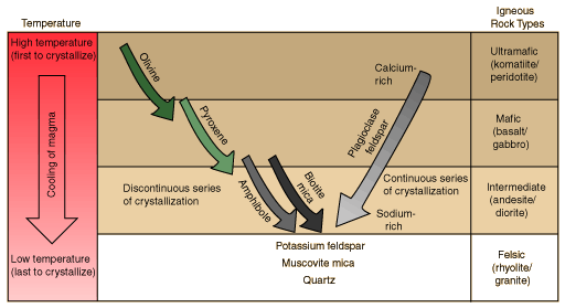
You might remember the Bowen's
Reaction Series from your introductory physical geography/general geology
course (http://hyperphysics.phy-
astr.gsu.edu/hbase/geophys/imggeo/bowen.gif).
-
In a magma body, fractionation of basaltic magmas can lead to the
concentration of silica. Olivine (Mg2SiO4 or
Fe2SiO4)
crystallizes out at higher temperatures, which thereby enriches the still
liquid
magma in SiO2. This still liquid and now silica-enriched magma
reacts with the olivine
to form pyroxene
(MgSiO4 or FeSiO4 + SiO2 ==>
2MgSiO3 or 2FeSiO3. Pyroxene crystallizes out at a
cooler
temperature. Reactions continue and amphibole (very diverse "recipes") and
biotite (K(Mg,Fe)3(AlSi3)(F,OH)2) crystallize
out at a cooler temperature yet.
-
Andesitic magma is more sialic (enriched in silicate and aluminum
minerals, aka silicic or felsic) than the basalts (simaic, or rich in silicate
and magnesium minerals, aka mafic), though not as sialic as rhyolite or
granite magma. It usually contains
pyroxene, quartz, feldspar, hornblende, and biotite. It is generally extruded
onto the surface by volcanic eruptions, which can be explosive
sometimes. This explosivity is because its higher viscosity ("stickiness")
traps gasses in the flowing magma and these expand
violently as the magma comes out from under the overburden pressure toward the
surface.
- Andesite dominance can result from sustained plate tectonics, because the
more silicic rock materials are more buoyant than the more mafic, and resist
subduction back into the mantle. So, Earth has a highly
differentiated crust
with basalts on the ocean floors and often quite granitic rocks and their
derivatives on the continents.
-
Crustal materials become both thicker and more silicic on Earth's continental
plates
-
When magma is produced under or on the edges of continents, it incorporates
the more silicic materials in the country rock, leading to a more andesitic or
even rhyolitic magma.
- Fractionation of this more siliceous magma, too, can lead to high
concentrations of rhyolitic/granitic magma.
- But the Earth analogy puts the formation of andesitic magmas under and on
the edges of continental plates and, on Mars, the andesitic material is
precisely where we would expect more basaltic rocks corresponding to Earth's
oceanic crust. Mars, once more, is the "yes, but..." planet.
- And Mars shows little evidence of plate tectonics, certainly not
sustained, mantle-recycling plate tectonics, complete with subduction zones
and divergence zones. So, you wouldn't expect advanced fractionation in any
event, but, what's perverse on Mars, is the slight differentiation of rocks
along the basaltic-granitic continuum (well, only to the point of andesitic,
anyway) is in the reverse direction: basalts on the Southern Highlands and
andesitics on the Northern Lowlands.
- The dominance of andesite can also result from alteration of
basalt
through interactions with ice or water. So, water is back in the picture, and
that picture is getting really complicated.
- Michael B. Wyatt et al. (2004) point out that MGS TES data show
basalts dominated by plagioclase feldspars and pyroxenes and, locally,
olivines. Olivine normally alters rapidly into other minerals, such as
hæmatites, iddingsite, gœthite, serpentine, chlorite, smectite,
and
maghemite in the presence of water. Very little of these secondary alteration
prodeucts have been found on Mars, except for a small amount of
hæmatite (Opportunity's findings), some iddingsite in martian meteorites
here on Earth, a bit of gœthite in Gusev Crater, some serpentine in Nili
Fossæ.
- Neither have other minerals indicative of persistent water been found,
such as the carbonates that should be abundant and are only found in small
amounts in a few places (and in more highland or dichotomy locations at that).
- From this, Mars looks as though it's been very dry and probably very cold
for all or most of its existence. You can't get comfortable with that idea,
though.
- Michael B. Wyatt et al. argue that the andesite was produced by
another process: alteration of basaltic magma through interactions with ice
near the surface and ice mantling the surface. During periods of high
orbital obliquity, ice could well have formed as far from the north polar cap
as
40°N.
- They conclude that the partially altered basalts formed in the Dry
Valleys of Antarctica and the summit of Mauna Kea are better Earth analogues
for the andesites and basaltic-andesites of Mars. So, if this argument can
help explain the andesitic tendencies in the Northern Lowlands, it will need
supporting evidence for the presence of enough ice at or below the surface to
enable this kind of reaction.
- One such evidence is the patterned ground seen in much of the
Northern Lowlands, which resembles polygonal structures formed in Earth
soils over permafrost in the active layer as water expands upon freezing
(water ice is alone among minerals in expanding at this phase change)
- On Earth, the size of such polygonal patterns is correlated with
how far
down the permafrost is and how thick it is
- The first images of these polygons on Mars at first seemed too large (up
to 30 km across!) to have anything to do with subsurface ice, but that might
simply have reflected the resolution of the spacecraft of the 1970s
(e.g.,
Viking orbiters)
- The new crop of orbiters is showing these patterns at the 10 m to 2 km
range and Phoenix recorded very small patterns surrounding it, which are
plausibly related to ice freeze-thaw stresses.
- Estimates based on these newer images are that the ice deposits begin no
more than 200 m below the northern lowland surface, where the putative
possible ocean lay.
- So, the Wyatt et al. argument may, indeed, "hold water" and,
further, lend support to the Parker thesis about an ocean or oceans once
occupying the Northern Lowlands. The Earth analogy of basalt-ocean floors and
granitic/andesitic continental uplands is misleading on a planet without plate
tectonics, having lost most of its atmosphere and surface water, and with such
extremely cold temperatures that the former oceans may have left some of their
water in the form of permafrost, where it can alter lava in the andesitic
direction.
- Something else that suggests a lot of subsurface frozen water is the
rampart crater. Rampart craters are pretty unique to Mars: They are
surrounded by
clearly fluidized ejecta blankets, kind of a "wet splat" effect,
scientifically
speaking (Mars scientists have sometimes called them "splosh craters!). They are believed to represent an impactor whacking an icy soil, a
soil or regolith with ice filling its interstitial spaces. The soil ice
evaporates and
liquefies in thermal and compressional shock. Liquefaction or heated gas
buoyancy result in a glop flying and
flowing out in a kind of impact lahar. This forms an ejecta
blanket of a very
distinctive sort, which flows over and around topographic obstacles, complete
with flow striations. Some have only single layers, others have double layers, and there
are a few with multiple distinct layers to the ejecta. Again, water (or some kind of volatile) seems to be back
in the picture.
-
Neutron spectroscopy on Mars Odyssey suggests hydrogen in soil, which you
would expect over subsurface ice or water bodies. Again, water gets a brownie
point.
-
Plot complication: It appears that there are as many craters under that
smooth northern plains surface as there are in the ancient Southern Highlands,
buried by those smooth deposits that look so, well, oceanic. These are
becoming evident through radar imagery (e.g., Mars Express MARSIS radar
altimeter) and through analysis of MGS MOLA data to find faint topographic circularities at the surface above buried craters. Only fairly large ones can be spotted under all that smothering cover, but if you compare larger craters in the Southern Highlands with these ghostly craters in the Northern Lowlands, the number and size distribution are pretty similar.
-
So, there is this ancient, pockmarked surface under there.
- There might be younger terrigenous and pelagic sediments on top of those (and an ocean
would explain the smoothing of those old craters so their walls aren't poking
out of the newer materials)
-
And then even younger (Hesperian? Amazonian?) basaltic magma spewed over all
this after
having been altered in the andesitic direction by interaction with buried ice
deposits or ice mantling the surface during high obliquity eras in Mars'
orbit? Could such a magma flood have buried every single last trace of the
pelagic sediments and their carbonates?
-
Isn't Mars just maddening?
-
The Southern Highlands:
The old, rough, cratered, high-elevation, and dusty southern two thirds of the
planet.
- The Southern Highlands are generally about 1-5 km above the mean martian
geoid (versus 0-3 km below for the Northern Lowlands), with a sometimes sharp
~1-3 km
slope dividing the two, as you saw in Lab 2.
- The Southern Highlands are also topographically the most diverse terrain
on Mars, ranging from 21 km above the "areoid" in the case of Olympus Mons
down to the floor of Hellas Planitiae, which is 8 km below the geoid (or ~9 km
below the regional high country)
- The total elevational contrast in the southern highlands, then, is ~25
km!
- Whirlwind tour of some of the (third order) subregions of the Southern
Highlands:
- Highest crater densities lie around Arabia Terra, probably the oldest
part of the martian surface
- Arabia Terra goes back to the Noachian era, the time of the great
bombardment from the time the planets emerged up until about 3.8 or 3.7
billion years ago
- So many craters, we can't even begin to use superposition to figure out
the oldest ones
- Arabia contains some of the few places on Mars where pretty much nothing
happened after that, so we can still see the ancient havoc
- It also contains some areas that have these weird layers that have been
exposed by what looks like wind erosion -- sediments? volcanic ash? lava
floods?
- Noachis Terra is another ancient, pummelled landscape
- It does show more signs of erosion and deposition, possibly by water
- Softened crater rims (relaxation and flow of subsurface ice?)
- Channels, including dendritic networks that look like Earth's
precipitation-fed fluvial networks
- Alluvial fans or features that look like them in craters at the mouths of
some of these channel networks
- Flattened floors to many craters (age, deposition of mass wasting
materials or fluid or wind deposited materials)
- Syrtis Major
- Dark wedge north of Hellas, west of Isidis, east of Arabia
- This is the first feature mapped by early telescopic observers of Mars
- Basalt terrain clean of dust
- Hesperian in age, going back to the times just after the great
bombardment ended
- A volcanic terrain with basalts washing over it to a depth of ~0.5 - 1.0
km, covering up the ancient craters, but old enough to have been pockmarked by
newer collisions
- Terra Tyrrhena
- Just south of Isidis and northeast of Hellas
- Basalt-dominated surfaces, covered with dust, so light colored
- Classic old, battered terrain, consisting of crater floors, crater rims,
crater ejecta blankets, and intercrater lands
- There may be old craters buried under newer surfaces, themselves smacked
with craters
- These surfaces have been modified in places by seeming fluvial processes
e.g., Vichada Valles network, Libya Montes) especially and by
æolian
processes
- Promethei Terra
- Just east of Hellas Planitia
- Another basaltic old cratered highland
- Evidence of landslides
- Some spectacular images of dust devil tracks taken by ESA Mars Express
HRSC
- Terra Cimmeria
- East of Hellas Planitia, southwest of Tharsis, south of Elysium Rise,
northwest of Terra Sirenum
- Another basaltic old cratered highland
- Part of the region where traces of the old martian planetary magnetic
field are preserved in east-west bands in basalts and were detected by Mars
Express' SPICAM
- Ma'adim Vallis, other seeming fluvial channels there. Ma'adim Vallis
shows a pattern of a long trunk and very short branches cutting back into
theatre-headed alcoves, a pattern seen in the American Southwest in stream
systems fed by groundwater seepage and undermining of valley walls, which
collapse to form these amphitheatre-like heads
- Meridiani Planum aka Terra Meridiani
- East of Valles Marineris outflow, northwest of Hellas, south of the
Arabia Terra/Acidalia Planitia border
- Younger (Late Noachian, variously 4.2-4.0 billion years to 3.7-3.8
billion years) but badly cratered countryside
- Home of the hæmatite concentration, which strongly implies water
- Opportunity's stomping grounds
- Margaritifer Terra
- Where Valles Marineris outflows swing northward, west of Meridiani
- Younger terrain filled with outflow channels (Ares Vallis) and chaos
terrain (Aram Chaos)
- Terra Sirenum
- Southwest of Tharsis and southeast of Cimmeria
- Another Noachian landscape with intense cratering
- Part of the region where bands of rocks preserving a magnetic signal from
Mars' early planetary magnetic field were discovered by Mars Express' SPICAM
- Xanthe Terra
- Directly north of eastern Valles Marineris, south of Chryse
- Ganges Chasma (of Lab 1 fame) is the source of the Shalbatana Vallis
outflow channel that pours into Chryse Planitia
- Other large outflow channels include Maja Vallis to the west and Simud
Vallis to the east, the smaller Nanedi Vallis between Shalbatana and Maja
valles, and Ravi Vallis east of Shalbatana
- Xanthe Terra is a Noachian "craterscape," featuring quite a mix of crater
sizes, which was then cut into by the later, Hesperian Epoch outflow events
- Tempe Terra
- The northernmost reach of the Southern Highlands, lying between about
30°N and 55°N, northwest of Xanthe Terra and northeast of the Tharsis
Rise complex
- It's also among the lowest of the highland terrains, much of it lying
below the geoid, though the transition to the Northern Lowlands is quite sharp
here
- It is distinctive for the number of long fossæ, a continuation of
the extensional stress and strain of the Tharsis uplift
- Lunæ Planum
- Northwest of Xanthe Terra and southeast of Tempe Terra
- Hesperian in age, so visibly younger than the adjacent Xanthe Terra
- Covered by what looks like flood basalts, probably from Tharsis activity
- Distinctively ridged, the ridging indicating compressional stress and
strain, possibly from the uplift of Tharsis, which created extensional stress
and strain features in Tempe Terra and in Valles Marineris but compressional
forces here
- Solis Planum
- On the other side of Valles Marineris from Lunæ Planum, extending
south toward the Thaumasia Highlands, east of the Tharsis Rise
- In some ways a continuation of Lunæ Planum, complete with wrinkle
ridges, especially to the east
- The southern boundary is marked by Thaumasia, a complex of folded and
faulted mountains, unlike the other mountains on Mars that are volcanic
edifices
- Summary of the first order discussion we have so far: A prominent part of the "first
order of relief" on Mars consists of the great crustal dichotomy, the drastic
contrast between the low-lying, smooth-surfaced, andesitic younger terrain of
the northern two-thirds of the planet and the much higher elevation, badly
cratered, basaltic, ancient terrain of the southern two-thirds of the planet.
-
This often quite sharp contrast has fed into the debates about whether Mars
once had oceans.
- Support for the oceans idea includes:
-
the presence of two
shoreline-like features (Contact 1 and Contact 2) at consistent elevations
around the lowlands
-
the consistent elevations of the outflow features' mouths
-
the smooth surface that would be expected from the formation of terrigenous
and pelagic sediments
-
estimates of martian primordial water that could plausibly have fed oceans
-
the neutron spectroscopic indications of quite a bit of subsurface water ice
or permafrost
-
evidence that Mars once had a denser atmosphere that could keep water above
the triple-point and allow it to exist as a liquid on the surface.
-
Inconsistent with the ocean hypothesis is:
-
the lowlands lithology, with its andesitic character so unlike Earth's ocean
floors
-
the nearly completely missing carbonates expectable from carbon dioxide
dissolution in water (if not necessarily from biogenic oozes).
-
These
objections are not insurmountable, however, in light of evidence of alteration
of highly basaltic lavas on Earth which have interacted during or after
emplacement with permafrost or ice (Dry Valleys of Antarctica and the icy peak
of Mauna Kea).
-
We also have to keep in mind that the "basalt ocean floor and
granitic continents" expectation is based on analogy with Earth and the plate
tectonic processes that differentiated Earth's magmas. On Earth, there is a
marked divergence between basalt and granite (Bowen's Reaction Series
planetary differentiation and magma body fractionation are quite well advanced) and these differentiated/fractionated products
continue to be altered today by very active weathering and interaction with water. While all of these processes operate on Mars, they have not gotten as far along as on Earth and, so, analogies with Earth can lead us astray on Mars.
|
![[ orthographic image of Mars on a black background ]](https://home.csulb.edu/~rodrigue/mars/marsblackbg.jpg)
![[ Olympus Mons seen at oblique angle that gives a 3-d sense ]](https://home.csulb.edu/~rodrigue/mars/olympusmons3d.jpg)
![[ Mars explorer ]](https://home.csulb.edu/~rodrigue/mars/marsexplorerpainting.jpg)
|
|
![[ image of Mars ]](https://home.csulb.edu/~rodrigue/mars/marsatlas.gif)