Lecture Notes for the Final
Noachian surfaces: The oldest
- See Viewgraphs:
- "3rd order: Noachian regions, Part A"
- "3rd order: Noachian regions, Part B"
- The Noachian covers the period from the earliest formation of the
planet during the process of the gravitational
accretion, collision, and consolidation of planetesimals, asteroids, comets,
meteoroids, and dust, ending when the flux of large bolides eventually fell
off.
-
Some people have begun to divide the traditionally understood
Noachian into the "pre-Noachian" and the Noachian proper, with the
pre-Noachian reserved for the time of planetary accretion, differentiation,
and development of the planetary magnetic field.
-
In this view, the
pre-Noachian ended at the point where crater saturation doesn't allow you to
discern
really old surfaces.
-
This would be the bold straight line on the
Neumann-Hartmann isochron chart.
-
That line represents a crater density so
intense that new craters obliterate old craters, so that you can no longer say
one surface is older than another.
-
When the pre-Noachian term is used, it continues up to the time by which the
dynamo had clearly shut down (as evidenced by the lack of remanent
magnetization in Hellas and other huge impacts).
- Most commonly, though, the whole period from the time of the planet's
origins to the end of the Late Heavy Bombardment is referred to as the
Noachian. So, the traditional Noachian includes:
- Primordial accretion
- The kinetic, compressional, and radioactive heating of the
accreted
materials
- Differentiation begins with melting of these materials and the
"iron
event," when iron, melting first, began to drift in blobs toward the
center of
the planet, pulling some siderophiles with it (particularly nickel).
- Formation of the mantle magma ocean.
- Formation of a crust on top of the magma ocean, in Mars' case,
apparently
quite a thick one, for reasons unknown.
- Mantle overturn because of the gravitational instability created
when
magnesium-rich olivine cumulates that crystallized out first at the hottest
temperatures were overlain by denser iron-rich olivine cumulates that
crystallized out later at a somewhat cooler temperature.
- Initiation of the planetary magnetic field through motion in the
outer, liquid iron-dominated core.
- The sustained bombardment of the differentiated planets as the
solar
sys tem was cleaned up of most of the stray smaller objects by the
gravitational fields of the early planets.
-
Some differentiated bodies were themselves smashed into asteroids and D
meteoroids, giving rise to the many different types of meteorites: chondrites
and carbonaceous chondrites from primordial material and achondrites, irons, ?
and stony irons from previously differentiated bodies.
- There was a drastic drop-off in the rate of bombardment around 3.7 or 3.8
Ga, but it may have crescendoed toward the end before tapering off: The
Late Heavy Bombardment (peaking between 3.92 and 3.85 Ga).
- While widely accepted, the LHB does have its critics, who feel that too
much was made of the concentration of lunar impact melts in the Apollo rocks,
which dated to a narrow interval around 3.9 Ga. Though rock samples were
taken from a variety of sites on the moon by Apollo (and the robotic Soviet
Luna sample-return program), there is a possibility that these may over-sample
ejecta from a single massive impact, the one creating the Imbrium Basin.
- The LHB, assuming the majority position, may have had a specific cause in
the movement of the giant planets Jupiter, Saturn, Uranus, and Neptune from
their areas of formation. This argument is called the Nice model
("neese," after l'Observatoire de la Côte d'Azur in Nice, France).
- Jupiter formed farther out than we see it now, while the other three were
formed closer in.
- Neptune was formed between Saturn and Uranus and migrated outward.
- The giant planets, in cleaning out their neighborhood of smaller objects,
exchanged angular momentum with them, causing shifts in their orbits
- Jupiter and Saturn eventually attained a 1:2 resonance (Jupiter orbits
the sun two times for every orbit of Saturn), and this created great
concentrations of their gravitational influences on Neptune and Uranus.
- Neptune was flung out past Uranus, right into the Kuiper Belt, and it
destabilized many of these objects, disrupting their orbits.
- Some were thrown into very inclined orbits (such as Pluto), some entered
into resonances with Neptune (such as Pluto, with a 2:3 resonance with
Neptune), others were scattered to the farthest reaches of the solar system.
- And a whole bunch of them were flung into the inner solar system, where
they hammered Mars, the Earth and Moon, Mercury, and, presumably, Venus.
-
If you'd like to learn more about this:
-
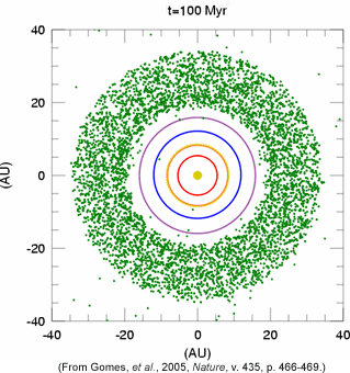
Here is an animation of the Nice model, with plenetesimals shown in
green, Jupiter's orbit in red, Saturn's in orange, Uranus' in purple, and
Neptune's in blue: http://www.psrd.hawaii.edu/WebImg/LHB-sim-small.gif
-
Here is one of the original presentations of the Nice model:
Gomes, R.; Levison, H.F.; Tsiganis, K.; and Morbidelli, A. 2005. Origin of the
cataclysmic Late Heavy Bombardment period of the terrestrial planets.
Nature 435, 7041 (26 May): 466-469. doi:
10.1038/nature03676.
- This hellacious era went on until about 3.9 to 3.7 billion years ago in
most accounts and as "recently" as 3.5 billion BP in others: There are still
a lot of controversies about when, exactly, the Noachian drew to a close. The
most commonly cited time in recent writings is 3.8 or 3.7 Ga.
- The Noachian roughly corresponds with the Hadean time on Earth
(4.6 to 4.0 Ga) and the early Eoarchean era (4.0 to 3.6 Ga), but, unlike on
Mars, we have very few rocks on Earth that date from this
time because of the intense geological activity here.
-
Well, let me qualify that: There are a few grains of zircons that old on
Earth, small crystals that were once part of igneous and metamorphic rocks.
-
Zircon contains some uranium, thorium, and lead, the ratios among which has
allowed them to be
radiometrically dated to as old as 4.4 billion years on Earth, in the case of
the Jack Hills zircons from Australia!).
-
There's been a controversy more recently about the age of actual metamorphosed
mafic/ultramafic rocks
in Canada that might be nearly as old as these zircons: the Nuvvuagittuq
greenstone
belt just east of Hudson Bay in northern Province Québec. These have
been dated to 4.3 Gya but the results are contested with claims that they're
no older than a "mere" 3.8 billion years old.
-
So, where on
Earth Hadean eon materials consist of a very few zircon grains and a
controversial claim for Canadian greenstones, on Mars,
roughly 40% of the planetary surface dates back to the comparable
Noachian
(Barlow 2010). Here is the Barlow map of martian surface ages: http://bulletin.geoscienceworld.org/content/122/5-6/644/F8.large.jpg.
-
So, while Mars is geologically active, it's nowhere near the level of activity
seen on Earth with its plate tectonism, and that has allowed the preservation
of ancient surfaces on Mars and their obliteration on Earth (except for those
zircons and maybe the Canadian greenstones)
- The constraint on the Noanchian timeframe is based on analysis and dating
of Moon rocks from similarly cratered surfaces brought back to Earth by
Apollo.
- This is a fairly elaborate reasoning process. Rocks were taken back to
Earth from the Moon by the Apollo astronauts from regions that had been
previously relative-dated by crater-counting techniques. The returned rocks,
then, allowed for an absolute date to be assigned to surfaces of previously
described as of particular relative dates.
- Then, the size-frequency curve for the Moon had to be calibrated for use
on martian surfaces, factoring in Mars' atmosphere (which would both destroy
more of the smaller objects and slightly reduce their incoming velocity),
Mars' location closer to the putative source of orbiting debris in the solar
system (closer to the asteroid belt and to Jupiter, the gravity of which
dislodges objects and puts them on new orbits, including orbits that intersect
the inner solar system bodies).
- You can get an overview of the Moon to Mars isochron correction system
(optional link for the curious: http://www.psi.edu/epo/isochrons/chron04b.html).
- Characteristics of Noachian surfaces
- Noachian surfaces on Mars are intensely cratered: craters on top
of
craters to the point that it becomes challenging to pick out which ones are
superposed on which others
- Noachian surfaces also show a great diversity of crater sizes,
with some
big craters mixed in with medium and small ones
- Noachian craters, too, show a lot of geomorphic
reworking:
- Very distinctive softening of the rims, as though they'd sagged and
spread out.
- Hardened ejecta blankets with that "wet splat" look, sometimes with two
or more layers of flowing ejecta, sometimes with the kinds of striations
produced by very rapid and fluidized movement, often ending in a rampart edge.
- Some of these craters were clearly buried by wind or water deposits, and
then subsequently re-exposed by erosion as pedestal craters perched like
crater-dented mesas high above the remaining landscape level.
- floors flattened by the deposition of alluvial, lacustrine,
marine, or æolian materials in them: You do not see that on the Moon,
which lacks such familiar geological activities as wind and water erosion,
transport, and deposition.
- There was quite a bit of this geological work back in Noachian times:
- Valley networks are found almost exclusively on Noachian surfaces,
showing fluvial action by what is more and more accepted as water, even
precipitation-fed channelization.
- There was some early and distinctive vulcanism in the highlands,
featuring plains formed from very low viscosity lavas (flood basalts,
possibly emanating from long rupes or fossæ), small cones, and very
shallow-sided vent-volcano edifices (pateræ).
- Later in the Noachian, volcanic activity became increasingly concentrated
in the two great volcanic rises, Tharsis and Elysium, which built up at this
time. The viscosity of lavas associated with the later volcanism allowed the
construction of very tall shield edifices and, in some cases, ashy eruptions
were part of the mix, which allowed the construction of steep sided tholi.
- The Late Noachian saw such extensive and massive volcanism that global
geochemistry was drastically changed.
-
Early Noachian geochemistry was dominated by phyllosilicate chemistry
(alteration of basalts in water to liberate silicas, including the kind of one
silicon/four oxygen tetrahedrons that produce micas, talcs, and clays).
-
Late Noachian and Early Hesperian geochemistry shows a strong sulfate
signal, as volcanoes spewed out massive amounts of sulfuric acid, carbon
dioxide, and water and created a strongly acidic aqueous chemistry.
-
This would explain the near lack of calcium carbonate on Mars: The
presence of sulfate
(SO2-4) and sulfur dioxide (SO2) prevents the
formation of calcium carbonate and favors the formation of hydrated calcium
sulfite (CaSO3 - H2O) instead, which can oxidize to
create sulfates, iron oxides, and more acidity.
- Most of the arguments about possible oceans on Mars place it in the
Noachian time frame, and, given the previous argument about sulfate chemistry,
if those oceans were strongly acidified, the lack of calcium carbonate on the
putative ocean floors becomes more comprehensible.
- Tour of Noachian regions
- I'll use a "walkabout" style of presentation, starting with the type
province (Noachis Terra) just west of Hellas Planitia and then go generally
west through Aonia Terra, Terra Sirenum, Terra Cimmeria, to Promethei Terra,
which takes us back to Hellas Planitia. From there, we'll swing up north to
Terra Tyrrhena and then go west and northwest into Terra Sabæa, Arabia
Terra, Margaritifer Terra, Xanthe Terra, and then Tempe Terra, leaving us
northwest of Alba Patera.
- Noachis Terra, the prototype, is a large region to the west of
Hellas and east and north of Argyre.
- This is a contender for the greatest crater density on Mars prize.
- Mariner 4 got images of Noachis Terra during its flyby, which created the
(then rather shocking) image of Mars as a dead, dry planet much like the Moon.
- Subsequent closer looks showed it to be a lot more interesting:
- The craters themselves turned out to be pretty strange
They often have softened rims and flattened floors, including some "ghost
craters" that are so softened and infilled that they have practically
vanished.
- Softened craters turned out not to be the result of standard-issue
erosion and deposition mechanisms: It's as though entire landscapes of old
craters sagged, spread out, and flattened, but new craters haven't.
- This suggests that there was a lot of soil moisture and ice back then,
which could flow, deform, and relax, softening the look of the ancient
craters.
- Pedestal and rampart craters were found here, too.
- These look like impacts into surfaces loaded with ice, which vaporized
and liquefied on impact, creating that "wet splat" look.
- The ejecta blankets appear to have solidified as a particularly resistant
material, which functioned kind of like a cap rock of resistant material.
- Erosive agents attacked the surrounding landscape, but the area under the
ejecta blankets was protected from whatever the regionally dominant erosive
agent was, leaving the crater and its ramparts of ejecta perched high above
the worn-down landscape, kind of like mesas with holes punched in the top.
- Drainage networks that looked like fluvial systems on Earth showed
that water or some other similar fluid ran over martian landscapes and eroded
them.
- Long networks featuring several tributaries, most of them fairly short
with few of their own tributaries, such as Nirgal Vallis
- Several smaller drainage basins with relatively long tributaries and
drainage densities larger than the Nirgal Vallis system's but smaller than
typical for Earth catchments and with nowhere near the degree of interfluve
dissection common on Earth
- The origins of such valley networks have long been contentious.
- Some authors argue for a precipitation-fed runoff history and the
evidence their existence gives to arguments that Noachian Mars had higher
atmospheric density and warmer temperatures, allowing at least for snow to
fall and liquid water to exist long enough to flow overland into drainage
channels (e.g., Gulick and Baker 1990; Ansan and Mangold 2006). This
would
pertain to the dendritic drainages.
- Others have pointed out that most such networks have fewer, shorter
tributaries than most Earth valley networks and that many of the short
tributaries originate in alcoves or theater-shaped headwalls most akin to the
slope morphologies of groundwater sapping-fed networks in arid Earth
environments (e.g., Laity and Malin 1985; Malin and Edgett 2000)
- Such morphologies can also be produced by meltwater from under
snow or ice cover even in very cold, arid conditions, as seen at a small scale
in and around Haughton Crater on Devon Island in northern Canada (Lee et al.
1999).
- Aonia Terra southwest of Noachis Terra and Argyre Planitia
- Its central areas are classic Noachian landscapes, highland cratered
units with many small dendritic valley networks.
- There is much evidence of contemporary æolian processes,
including large dune deposits at the base of some crater rims, with
some evidence of dunes overtaking older dunes trapped against a topographic
barrier.
- Much of the Aonian cratered landscape shows signs of being subdued in
contrasts, very akin to the crater softening and flattening seen in the
discussion of Noachis Terra.
- There is a heavy profusion of larger craters in Aonia Terra, many
showing the pedestal structure seen in Noachis Terra. The pedestals preserve
craters on a surface once higher than today's, about 500 m higher (Head et al.
2003), which was eroded away around the craters and their resistant ejecta
blankets by, presumably, meltwater from once larger polar ice deposits.
- Aonia Terra has extensive development of Hesperian aged flat and
rather featureless plains, particularly in the northern part of the region
just south of the Tharsis mountains. These have been interpreted as being
comprised of thick beds of alternating lava flows and æolian deposits
that have buried underlying terrain (Scott and Tanaka 1986).
- Terra Sirenum west of Aonia and south of Tharsis
- Terra Sirenum is a profusely cratered basaltic terrain of the Southern
Highlands, located to the southwest of the Tharsis rise.
- It shows a diversity of surface ages, though the preponderant surface
exposure is Noachian
- There are several large craters with diameters exceeding 100 km
and some exceeding 300 km.
- Again, we have the valley networks of apparent fluvial origin
- A particularly striking feature of Terra Sirenum and its neighbor, Terra
Cimmeria, was revealed by the Mars Global Surveyor magnetometer: marked
linear bands of alternating remanent magnetization, trending east-west
across these two adjacent regions.
- Linear magnetic bands like Earth's spreading zones that record
polarity changes in our planetary magnetic field?
- Accretion of terranes through plate tectonics, each with a
different magnetic signal from the long-vanished martian magnetic field?
- Intrusion of magnetite/ilmenite dikes associated either with rift
zone spreading or some other magmatic source?
- Terra Cimmeria northwest of Sirenum
- In many ways, Terra Cimmeria is essentially the westward extension of
Terra Sirenum into the eastern hemisphere, out to ~ 120° E: It shares the
same common range of elevations, the same general distribution by size class
of ancient craters, and, with Terra Sirenum, houses the same east-west bands
of remanent magnetization, and it is rarely discussed without its neighbor.
- It retains a separate name as its inheritance from the names given to
albedo features seen from Earth in the nineteenth century.
- It made news in its own right when an aurora was recorded by ESA's
Mars Express SPICAM instrument (Bertaux et al. 2005) at 177deg; E at -52°.
- It also was the destination of Mars Exploration Rover, Spirit,
which landed in Gusev Crater at the end of Ma'adim Vallis in the northeastmost
corner of Terra Cimmeria.
- Ma'adim Vallis is, like Nirgal Vallis discussed under Noachis Terra, a
long channel with several short tributaries suggesting some sort of sapping
process more than the dissection of a fluvial network fed by precipitation and
spring flow.
- It may have had at least one jökulhlaup massive outflow episode.
- Its morphology and the presence of delta-like deposits in southern Gusev
Crater led to the selection of Gusev Crater as the landing site for the Mars
Exploration Rover Spirit in the hope of finding sedimentary deposits.
- Spirit landed, instead, on a basaltic lava flow, probably from
Apollinaris Patera to the north, which was emplaced after the Ma'adim Vallis
flows
- Water-altered strata were not found for 159 sols until Spirit reached an
outcrop of groundwater-altered volcanic ash exposed in the Columbia Hills.
- This was quite a "Mars, the yes, but ..." planet scenario.
- Promethei Terra just east of Hellas Planitia
- West and southwest of Terra Cimmeria, Promethei Terra lies adjacent to
the eastern margins of Hellas Planitia.
- Like all the Noachian regions, it is generously covered with craters in a
profusion of size ranges
-
The landscape features ancient rugged highland terrain interspersed
with lower elevation basins filled with sediments eroded and
transported from the highland massifs.
- In southernmost Promethei Terra is a roughly half-circular ridge,
Promethei Rupes, which is evidently the remnant of a very large impact basin
now mostly covered by Planum Australe.
- Evidence of valley networks is apparent, as well, and northernmost
Promethei Terra is the source region for one of the great outflow
channels debouching in eastern Hellas: Harmakhis Vallis, its tributary
Reull Vallis, and the tributary of the latter, Teviot Vallis.
- The region is quite dusty, and dust piles up in great beds dozens
of meters thick in many a crater.
- Lighter coverings of dust often show networks of ornate dark streaks and
curlicues, which were shown to be dust devil tracks disturbing the dust
and exposing the basalt below, a phenomenon first clearly documented in the
process of formation in Promethei Terra and since found all over Mars.
- Many of Promethei Terra's craters are dramatically softened, with
eroded or sagging rims and floors flat with infill. This has long been
posited as the result of a large amount of interstitial soil ice and
permafrost close to the surface that has undergone viscous relaxation
over time, the surface layers flowing and deforming in lineated and lobate
structures, sagging and creeping into arcuate ridges in valleys and
crater bottoms.
- Interestingly enough, these thaw/melt/flow features were pole-facing at
latitudes less than 45° and equator-facing at latitudes greater than
45°, reflecting a dependence on total solar radiation rather than
intensity of solar radiation.
- Total solar radiation is affected, not only by slope aspect with respect
to sun angle as it varies over the course of the day and the seasons, but with
changes in orbital eccentricity and obliquity.
- Evidence of glaciation during Mars' last high obliquity phase about 5.5
Ma are abundant in Promethei Terra, including a particularly striking
hourglass-shaped pair of craters with a fill showing flow lines leading from
the higher to the lower, which turned up in HRSC imagery.
- Terra Tyrrhena north of Hellas Planitia and south of Isidis
Planitia
- Like most Noachian surfaces, Terra Tyrrhena's is a crater-littered
landscape, its central plateau dating back to the Late Noachian and Early
Hesperian and its surrounding lower elevation plains made up of younger
Hesperian materials, largely volcanic.
- Many of the craters show substantial filling and flattening of the floors
and erosion of the rims.
- The region shows signs of fluvial dissection in the zones between the
older highlands and the younger lower elevation surfaces, with well-developed
and often well-integrated valley networks, with tributary systems
attaining up to the fourth order in the Strahler system of stream ordering.
- Unaltered olivine of the original Noachian surface rock is shown
in CRISM spectroscopy, sometimes covered with somewhat altered lavas but then
excavated by impacts. Olivines are very rapidly altered in the presence of
water into such minerals as serpentine, goethite, iddingsite, or
hæmatite.
- The team operating the OMEGA spectrometer on the European Space Agency's
Mars Express found the first clear evidence of phyllosilicates exposed
in crater walls and in eroded ejecta blankets around craters in Terra
Tyrrhena, notable for the dependence of phyllosilicate formation on the
interaction of rock with abundant neutral to high pH water. Phyllosilicate
clays are alteration products of fairly neutral water acting on basalts.
- Subsequent work has shown that the phyllosilicates are widely distributed
on Mars, but only on Noachian terrain, such as Terra Tyrrhena, and of a
diverse range of specific minerals (Marble et al. 2008).
- The presence of phyllosilicates and the neutral or somewhat alkaline
aqueous chemistry they indicate goes against the impression created by all the
unaltered olivine and basalt. That "yes, but ..." quality again.
- Terra Sabæa northwest of Hellas Planitia
- Terra Sabæa is a heavily battered low albedo landscape located
northwest of the Hellas Planitia rim and wrapping around Syrtis Major to its
east.
- It shows a wide range of crater sizes, again in nearly saturated
profusion, as well as a number of Late Noachian fluvial valley
networks.
- Terra Sabæa, of all the Noachian regions, seems underrepresented as
a setting for particular investigations, as I found out when I did my
secondary crater prospecting study there.
- Arabia Terra northwest of Hellas Planitia, north of Noachis Terra,
and east of Chryse Planitia
- Crater density is so great here, vying with Noachis Terra for the
greatest densities on the planet, that superposition breaks down as a method
of picking out the oldest craters.
- The region is bounded to the north by the transition scarp down to the
Northern Lowlands but, here, it is far less distinct and more
fretted and intricately graded than it is in other parts of Mars.
- The crust is considerably thinner under Arabia than under other
parts of the Southern Highlands, too, more akin to the crust under the
Northern Lowlands.
- The northern and western portions of Arabia Terra are distinctive for
areas of older cratered terrain, "inliers," standing isolated as buttes and
mensæ towering over the far lower terrain comprising the bulk of the
landscape there.
- These inlier features often expose marked layering, as, for
example, in Cydonia in northwestern Arabia and its infamous "Face on Mars"
mensa.
- The layering suggests burial of a Noachian surface and then its
exhumation from under younger materials.
- Construction of a 1 m resolution digital terrain model from the Mars
Reconnaissance Orbiter's HiRISE instrument's stereo images permitted Lewis et
al. (2008) to construct detailed topographic profiles of bedding outcrops in
four Arabia Terra craters and measure layer widths.
- Beds show rhythmic variations in width, which authors attribute to
extraplanetary climate drivers, such as changes in orbital
eccentricity, precession, and obliquity.
- Arabia Terra's rhythmic sedimentary layers, then, join the polar deposits
as potential archives of martian climate change and calibration of the
crater counting based geological record.
- Margaritifer Terra east of Valles Marineris, west of Arabia Terra,
north of Noachis Terra, and south of Chryse Planitia
- About 60% of its area is comprised of surviving heavily cratered surfaces
of Noachian age.
- It is quite distinctive, however, for the concentration of outflow
channels and chaos terrain.
-
Most of these show the reduced cratering of Hesperian age surfaces.
- Margaritifer Terra collected outflows from the following sources:
- the eastern end of Valles Marineris (Hesperian outflows)
- the Chryse Trough drainages (probably Noachian fluvial systems of varying
connectivity and continuity)
- sources internal to the region, in the form of the many chaos terrains
that themselves would have created massive jökulhlaup-like
outflows during the Hesperian:
- Auroræ
- Pyrrhæ
- Asrinoses
- Aureum
- Margaritifer
- Iani
- Hydraotes
- Hydaspis
- Aram chaoses
- The outflow channels cutting through Margaritifer Terra do not show the
dendritic structure of precipitation-derived surface and groundwater-fed
fluvial networks, such as the many small valley networks seen on Noachian
surfaces and such channels as Ma'adim Vallis and Nirgal Vallis, respectively.
- That is, they do not originate in a series of low-order streams fusing
their flows into progressively higher-order, larger discharge branches and
trunks per Strahler.
- Rather, they originate in chaos terrain and emerge at full width
below it, which they generally substantially preserve throughout their
lengths, dwindling only far downstream.
-
They show close to U-shaped or even box-shaped cross-sections,
which suggests massive, sudden, and probably short-lived flooding of the
jökulhlaup character, perhaps triggered by warming of
subsurface ices
by magmatic intrusion, perhaps in a system of dikes.
-
Indeed, the outflow channels of Margaritifer Terra, Xanthe Terra, and
Lunæ Terra have been characterized as, by far, "by orders of magnitude
the most voluminous known fluid-eroded channels in the Solar System (Rodriguez
et al. 2007).
- The chaos features at the heads of these channels and the hummocky,
lineated, terraced lower reaches have been characterized as
thermokarstic on the basis of Earth analogues in Siberia.
- One of the "yes, but ..." qualities of these massive outflow channels,
here in Margaritifer Terra and in the other borderlands of Chryse Planitia is
the question about how much atmospheric density Mars would have had to have to
sustain that much liquid for the duration of the jökulhlaup-type event
and for what looks like ponding or pooling of this water in the Northern
Lowlands. When would Mars have been above the triple point of water?
Noachian times, but the crater density pattern in the Margaritifer Terra
outflow channels is much lighter and not as diverse in size as we see on
Noachian surfaces: They are more in line with Hesperian times.
- This discrepancy has fed skepticism that the fluid involved was, in fact,
actual water.
- Probably the most commonly proposed fluid is brine. The brine
would be comprised of the chlorine and sodium in magma, which can combine to
form salt or sodium chloride. Under impact gardening conditions, this salt
would be joined by calcium and magnesium and other elements in subsurface
water to form a very complex brine, and such brines have very low freezing
points, in some cases as low as 225 K or -48° C.
- Concentrated brines might thus account for the ability of subsurface
fluids to sustain the kinds of flows in the outflow channels of Margaritifer
Terra, as well as the small seeps and gullying witnessed even today on martian
crater walls (Knauth et al. 2001; Knauth and Burt 2002).
-
The brines would be
activated by subsurface warming, perhaps due to magma intrusion regionally or
in the form of dikes ascending into frozen soil brine.
- Another scenario proposed by Nick Hoffman is that the fluid involved is
actually carbon dioxide: Carbon dioxide sublimes extremely violently
upon depressurization and the kinds of flows seen in Margaritifer Terra and
Valles Marineris could have been gas-supported flows more like pyroclastic
flows in their behavior. Talk about popping the soda bottle after too long a
trip in a car with bad shocks!
- Still another proposal is that lava deposition during the formation of
Tharsis could have heated thick underlying deposits of hydrous sulfate
evaporites, as may be exposed, for example, in the walls of Valles
Marineris. If so, the heat could have caused dehydration of the
evaporites and segregation of the water, which would have increased their
volume and thereby pressured the segregated water into explosive release
(Montgomery and Gillespie 2005).
- Xanthe Terra west of Margaritier Terra and northeast of Valles
Marineris
- Like any Noachian landscape, Xanthe Terra is badly battered with a wide
range in sizes of craters, including many with diameters in excess of
10 km.
- Like Margaritifer Terra next door, Xanthe Terra also has a number of
outwash channels crossing it but in a more organized north/northeast
direction:
- Shalbatana Vallis to the east, originating in chaos terrain north of
Ganges Chasma (site of Lab 1)
- Maja Vallis, a large channel originating in Juventae Chasma. Maja Valles
comprise Xanthe Terra's western boundary (with
Lunæ Terra)
- Nanedi Valles, a smaller channel system between Shalbatana Vallis and
Maja Valles
- There is some discrepancy in regional usage in the literature: Some
authors refer to Tiu Vallis, Simud Vallis, and Ares Vallis as part of Xanthe
Terra, using Ares Vallis as the eastern boundary, but the USGS, NASA, and IAU,
in the planetary gazetteer prefer to confine Xanthe Terra to the area directly
north of eastern Valles Marineris. I'm only mentioning it here, because you
may encounter discrepant usage in older writings.
- While many Noachian regions show modification of the basic crater-pocked
surface by wind, ground ice, groundwater, or surface water, Xanthe Terra,
however delimited, shows an unusual concentration of different types of
modification:
-
groundwater sapping
- weak fluvial network development
- the massive outflows (jökulhlhaup) mentioned earlier
- permafrost
-
chaos terrain formation (subsurface fluid withdrawal and surface
collapse)
-
volcanism
-
landslides
-
æolian processes
-
diagenetic processes (alteration in situ) generating layering
that resemble the stratigraphy of sediments or volcanic flows
- Tempe Terra far northwest of Xanthe Terra and northeast of
Tharsis.
- Lying well to the northwest of Terra Xanthe and off the northeastern edge
of the Tharsis Rise, Tempe Terra is the northernmost reach of the cratered
Southern Highlands and a kind of isolated outlier of Noachian territory.
- It is the lowest lying of the "highlands," as well, with perhaps half of
the region lying below the geoid, though Tempe Terra surfaces may stand as
high as 3-4 km above nearby Northern Lowlands elevations.
- The transition scarp is quite steep in northern Tempe Terra.
- As in Arabia Terra, much of the transition from the cratered highlands to
the lowlands is marked by taller mensæ and knobs separated by
swaths of lower and smoother terrain that descend to the lowlands in a series
of steps.
- Though much of the region lies below the geoid, the southwestern and
central portions are mostly above, and there are areas in the center and
scattered along the west and south that reach above 1,000 m.
- Making Tempe Terra quite distinctive among the Noachian regions is the
presence of long and sometimes sinuous fossæ, as well as
catenæ (linear arrangements of subsidence pits often set off by
extensional stresses), which fan out from a common center on the northern
portion of the Tharsis rise, e.g.,
- Mareotis Fossæ
- Tempe Fossæ
- Labeatis Fossæ
- the largest catena is Baphynis Catena
- This is the region of Mars showing the greatest seismic strain,
according to a team headed by Matthew Golombek, who measured fault throw and
distortions in the shape of craters to estimate the degree of extensional
stress in Tempe Terra.
- So, that concludes our tour of Noachian Mars, which comprises much of the
planet. Each of these terræ, plana, and planitiæ share dense
cratering approaching saturation levels, with a "striking" mix of different
crater diameter sizes. It is in Noachian Mars we see valley networks, some of
them quite dendritic and approaching fourth level stream order. There are
also quite a few long trunk/short tributary systems with
theatre-headed alcoves in their upper reaches, possibly groundwater-seepage
systems akin to those in the American Southwest. Noachian Mars also shows a
range of volcanic types, from the common flood basalts and ridged plains to
shield volcanoes and some steep-sided volcanic edifices, with evidence that
concentration of magma sources had taken place over the Noachian, culminating
in its concentration in the two great volcanic rises, Tharsis and Elysium.
Many of the ancient Noachian surfaces have been reworked, sometimes
dramatically, by various geomorphic agents, such as wind, fluvial processes,
glaciation, volcanism, and permafrost in more recent Hesperian and Amazonian
times.
|
![[ orthographic image of Mars on a black background ]](https://home.csulb.edu/~rodrigue/mars/marsblackbg.jpg)
![[ Olympus Mons seen at oblique angle that gives a 3-d sense ]](https://home.csulb.edu/~rodrigue/mars/olympusmons3d.jpg)
![[ Mars explorer ]](https://home.csulb.edu/~rodrigue/mars/marsexplorerpainting.jpg)
|
|
![[ image of Mars ]](https://home.csulb.edu/~rodrigue/mars/marsatlas.gif)