Lecture Notes for the Final
Second order of relief: gigantic features and the dominant processes
shaping the martian surface
-
Mars' surface physiography shows conspicuous evidence of several geomorphic
processes: impacts and cratering, volcanism, rifting, glaciation, hydraulics,
and æolian processes.
-
These processes have created enormous landscape features, some visible with
telescopes from Earth, which constitute the second order of martian relief.
-
These features are generally between 1,000 km to 8,000 km in diameter or
length: four
enormous impact basins, the other great volcanic rise, the Valles Marineris
rift system, the possible mega-slide of Thaumasia, the polar ice caps, the
Chryse Trough drainage system, and the Syrtis Major wind-cleared basalt
region.
-
Together with the first order great crustal dichotomy and Tharsis Rise, these second order
features provide a framework on which to hang an increasingly detailed mental
map of Mars.
-
The great impact basins
- See Viewgraphs:
- "2nd order: Great craters (Hellas, Argyre)"
- "2nd order: Great craters (Isidis, Utopia)"
- Much of Mars is cratered, but there are four impact craters that stand
out by their tremendous size, ranging from 1,500 km to 3,300 km in diameter.
They also feature positive gravitational anomalies (mass concentrations, or
mascons, coïnciding with topographic lows), which seem counterintuitive,
given the tremendous excavation of mass from them.
-
Hellas Planitia
- This crater spans about 50° of longitude and 30° of latitude,
centered about -42° at 70° E.
- It is some 2,300 km across and 8 km deep relative to the surrounding
countryside (about 4 km below the geoid)
- Striking thought: If all the material excavated by the impactor that
created Hellas were sifted evenly all across the contiguous continental United
States and slowly built up, it would cover us up to a depth of 3.5 km or so
- Indeed, the material blasted out of Hellas accounts for a large share of
the higher elevation of the Southern Highlands over the Northern Lowlands,
according to Arden Albee (2000, Annual Reviews of Earth and Planetary
Science). It amounts to several hundred kilometers in width by some 2 km
in depth.
- This argument is what got me to thinking that, if Hellas could disgorge
this much ejecta, wouldn't the Northern Lowlands impactor have deposited
vastly more ejecta, perhaps accounting for a very significant share of the
raised elevation of the Southern Highlands?
- The Hellas event is believed to date from the end of the Noachian era
(which ran from the beginning of the planet's coalescence to maybe 3.8 billion
BP).
- When an impactor of this size hits, it vaporizes and melts solid rock.
- Magma containing iron minerals (which the basalts of Mars' Southern
Highlands have a lot of) aligns with the then prevailing magnetic field
- Hellas shows no such remanent magnetization, so it formed after the
collapse of the
Martian magnetic field
- The crust is very thin here, < 10 km thick, perhaps as little as 7 km,
related both to the explosive excavation and to the rebounding of the mantle
afterwards.
- Hellas went through extensive reworking after its excavation:
- It may have contained a great inland sea, with a volume about two thirds
that of the proposed Northern Lowlands ocean.
- The floor deposits are largely Hesperian in age (younger than the
Noachian times of its formation, but older than the Amazonian age of the
Northern Lowlands surface)
- Hellas shows all sorts of interesting erosional and depositional
landforms expressing this complex geological history:
- Depositional:
- Volcanic wrinkle ridges and pyroclastic flows
- Mass wasting/landsliding
- Fluvial alluvial fans
- Lacustrine/marine layered deposits
- Æolian dunes
- Ground ice or glaciers
- Erosional:
- Fluvial outflow channels
- Lacustrine/marine shorelines
- Æolian yardangs
- Argyre Planitia
- Another girnormous crater centered around -49° lat. and 318° E.
lon.
- It's not as large as Hellas, with a diameter about 1,800 km and a depth
of 5 km
- It is visually distinctive due to the rugged mountain massifs that form
ring and radial fretting patterns around the floor of the crater.
- The radial pattern is enhanced by five major channels flowing into and
out of the basin: four entering from the south and one flowing out of the
north rim.
- Muddying my tidy nested regionalization scheme, apparently, Argyre, a
second order feature, is involved in another second order feature I'll discuss
later, a tremendous seemingly fluvial system draining from beneath
the south polar cap through a chain of crater lakes and river channels leading
to Ares Vallis and Chryse Planitia.
- Many of the same erosional and depositional features seen in Hellas
Planitia can be found in Argyre Planitia
- Dunes trapped on crater floors: Easily transported into craters but
nearly impossible to be lifted out
- Dust devils do try, though, and there are dust devil tracks in Argyre
- Complex layering, possibly of lacustrine deposits, lavas, dust, which
then get differentially eroded, nowadays mostly by wind
- Gullying is seen in Argyre: water? brines? carbon dioxide dry ice?
- Of the four great impact basins, the floor of Argyre is the oldest,
judging from the superposed crater density, probably late Noachian in age.
- Isidis Planitia
- Isidis is the third of the great impact basins found in the Southern
Highlands, but, unlike the previous two, it is found right on the first order
crustal dichotomy border, again kind of messing up my tidy "orders of relief"
scheme.
- It's centered roughly at 15° at 90° E.
- Very distinctively, Isidis has almost no remnant of its northern and
northeastern rim structure: The crater opens out onto the Northern Lowlands
over a gradual rise of only about 500-600 m from the lowest point of the
crater floor.
- It also has the thinnest crust of the four great craters, ~6 km.
-
It also features a higher level of post-impact fill, nearly 3 km deep, giving
it the flattest floor of the three, with a slope about 0.015°, tilting
down toward the southwest and then reversing to form a smooth but steeper
slope rising to the southwest into Syrtis Major.
- There has been energetic debate about what the nature of that flat fill
is.
- One group argues that this is a basalt flow from the Nili and Meroë
Patera volcanoes in the Syrtis Major region to the west the likeliest sources
- Others point out that most of the basin tilts downward toward the
southwest, so that would be weird if this were lava from those volcanoes.
- Another argument against the Nili and Meroë Patera volcanoes is that
their lavas have much greater surface roughness than the Isidis fill.
- There's been speculation that the fill might be catastrophic debris flows
triggered by Syrtis Major volcanic dikes interacting with ice-rich soils,
particularly ices rich in carbon dioxide. That interaction would trigger an
explosive outflow, perhaps destroying the crater's northeastern rim.
- Going against that idea, though, is the lack of chaos terrain and
channeled outflows of the sort we see farther west in the borderlands of
Tharsis.
- Still others think that, however that northeast rim was broken, its
failure allowed a marine intrusion from the posited Northern Lowlands ocean,
kind of a big lagoon, complete with smooth marine deposits.
- The various positions on this debate are summarized in Hiesinger and
Head, 2004, Lunar and Planetary Science Conference.
- Like the previously discussed craters, Isidis has a very complex
geological history: volcanic, marine, permafrost, mass wasting, and
æolian features
- Given the possibility of ocean incursion from the Northern Lowlands
through the blown-out norther rim of Isidis, some of the coastline suggestions
(the Deuteronilus Contact) have been traced into Isidis.
- Among these are a lot of dunes forming fields with ripple structures
- It has a high density of smaller craters. It is probably younger than
Hellas, though, basically puncturing its annular ring.
- However, many of these craters are eroded mounds with pits at the top
- Their appearance suggests that there was once some kind of sediment or
other filling in Isidis even higher than it is now, which was then smacked by
craters, which consolidated the areas around the impacts under the ejecta
blankets. If the area contained permafrost, the result was that "wet-splat"
rampart crater.
- Later, erosion (wind?) removed whatever these beds were, leaving the
consolidated crater rims to stick out more and more prominently above the
lowering floor: pedestal craters.
- This intriguing crater is where Beagle 2 was to land on 25 December 2003
- Utopia Planitia
- A lava plain in the northern lowlands, located roughly at the antipode
from Argyre, about 46° lat. and 119° E lon.
- This is where Viking 2 landed in 1976.
- This is where Viking 2 recorded the formation of thin frost layers on
rock and
soil, which may form when CO2 in the atmosphere freezes out,
attaches to dust particles (themselves the condensation nuclei for water), and
then settle down like a kind of fog frost
- This is also the landing site of the Tianwen-1 lander and Zhurong rover, which are
working to the southwest of Viking 2 and west of Elysium Rise, about halfway from Viking 2
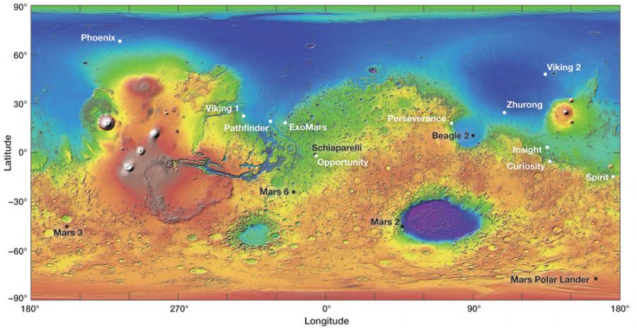
to Isidis Crater. A map of all landers and rovers can be accessed here.
- Zhurong has identified hydrated minerals there in sediments that date to the Amazonian (relatively recent), probably materials altered by groundwater rather than surface water.
- The consensus now is that Utopia Planitia is a humongous crater buried in
whatever it is that resurfaced the Northern Lowlands. This was first proposed
in 1989, when G.E. McGill published an article in JGR arguing from
geomorphic evidence that there was some kind of circular structure buried in
the Northern Lowlands. His argument has basically received increasing support
with every
new data source collected on it, though there are still some holdouts saying
that not all alternative explanations have been systematically ruled out.
- There are odd circular grabens on that Northern Lowlands surface
material.
- These look almost like the draping and sagging and fracturing of some
layered material over buried crater structures
- Mars Express has ferreted out buried craters on Chryse Planitia
- This would be consistent with ocean sediments in an argument by Debra
Buczkowski and George McGill in 2002
- Might that consistency not preclude low viscosity lavas?
- If this is, indeed, a crater, it is the largest of the four discussed
here as second order features at 3,300 km across (conservative estimate) to
4,700 km across (more inclusive definition).
- It is, moreover, covered by the buried "quasi circular depressions" that
MOLA and Mars Express have found all over the Northern Lowlands, revealing an
ancient surface under that smooth resurfacing. Since, the resurfacing is
newer, Amazonian material and the QCD are necessarily much older (probably
Noachian like much of the Southern Highlands), then something buried under
them is older still.
- Utopia is far from the equator and gives a lot of evidence of
ice-related features and processes:
- Viking 2 documented the first evidence for the frequent formation and
sublimation of frost and ice fogs.
- There's patterned ground, the polygons often seen on Earth over
permafrost.
- There's evidence of sublimation of subsurface ice in the form of
scalloped pits and thermokarst.
- There are lobate debris aprons of the sort you see in solifluction
affected Arctic terrain.
- Pedestal craters are found here and in other high latitude locations: An
impact crater sits at the top of a mesa several times wider than it is,
surrounded by a steep scarp that perches the whole landform dozens of meters
above the surrounding plains. These have been interpreted as impact-hardened
ground and ejecta blankets set in a soil substrate susceptible to æolian
erosion.
- There is also evidence that groundwater has operated in Utopia Planitia, altering and hydrating minerals there all the way into Amazonian (recent) times (Kornei 2022).
|
![[ orthographic image of Mars on a black background ]](https://home.csulb.edu/~rodrigue/mars/marsblackbg.jpg)
![[ Olympus Mons seen at oblique angle that gives a 3-d sense ]](https://home.csulb.edu/~rodrigue/mars/olympusmons3d.jpg)
![[ Mars explorer ]](https://home.csulb.edu/~rodrigue/mars/marsexplorerpainting.jpg)
|
|
![[ image of Mars ]](https://home.csulb.edu/~rodrigue/mars/marsatlas.gif)