Reconstructing the history of Amenthes Planum
This lab has the following objectives:
- to have you apply Gridview to landscape interpretation
- to refamiliarize you with the Mars Gazetteer
- to introduce you to geological maps for Mars and their terminology
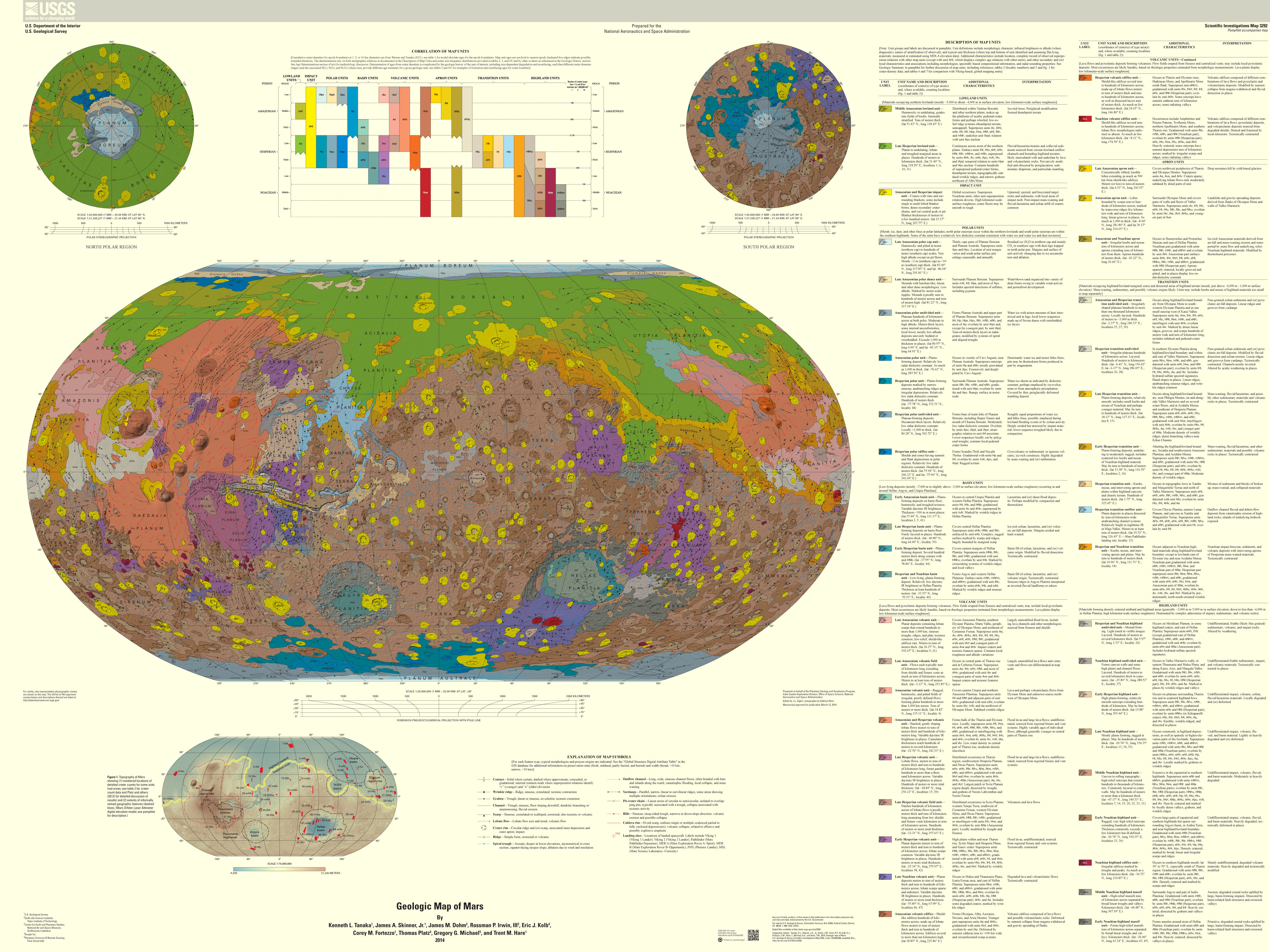
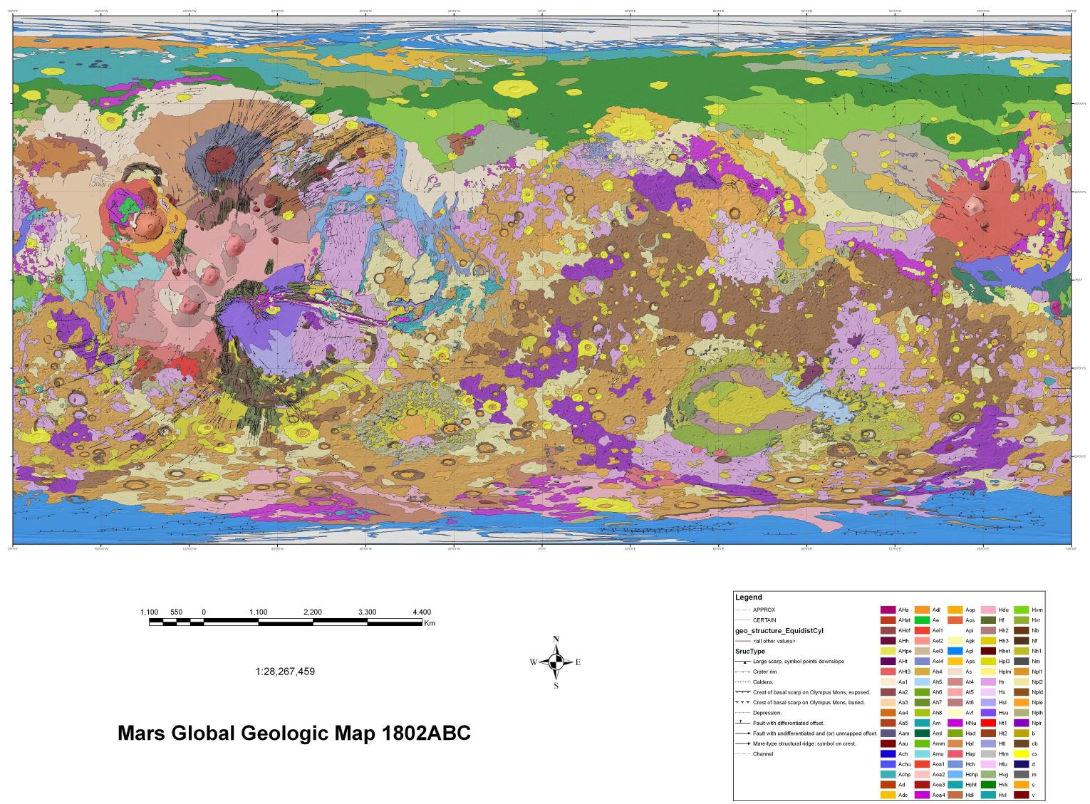
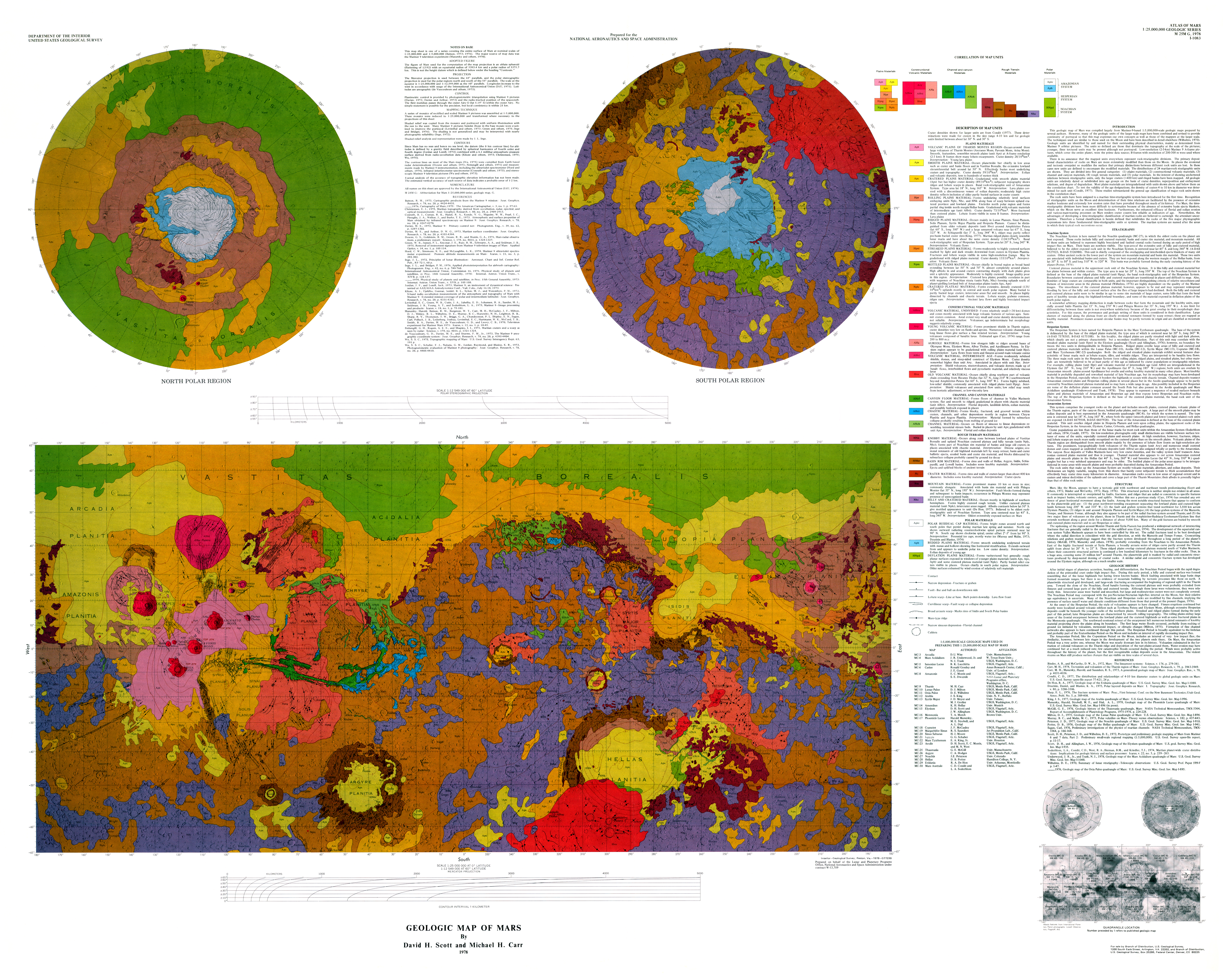
- to let you see the progression in geological understanding of the greater Amenthes region as you view maps from 1978, 1986-87, and 2014
- to have you do crater counts on four geological units in the Amenthes
Planum area (the fill material and the border units), using my crater counting spreadsheet to speed things up
- to use crater-count ages, superposition, and cross-cutting relationships
to infer which processes had to occur in which order there
- to give you the (optional) opportunity to apply HiView and/or JMars to your problem
- to give you practice in writing up the results of your analysis
Your resources
Now what?
First, do a search on Amenthes Planum in Google Mars to get its approximate whereabouts.
Second, pin it down by using the Mars Gazetteer, which will give you the
currently accepted borders of Amenthes Planum.
Third, go visit the site in Google Earth Mars and wander around in there to
get a sense of the landscape. Check out the grabens and wrinkle ridges
(Amenthes Fossæ and Amenthese Rupes) and where they start and end.
Fourth, use Gridview to do a profile along the Amenthes depression and then
two more at right angles to it, one toward the mouth and one toward the upper
middle. Try out the MOLA_32.sav file (big file!) instead of the MOLA_04.sav you're already
familiar with. No matter which .sav you use, these are not like all those profiles you did up and down various valles, eh?
Fifth, go to the Robbins crater database and do crater counts for four
small square areas, two in the middle of the depression and others nearby
in the highlands to the east and west. Just like
you did in Lab 6, save each Robbins crater file as a CSV file and open it in a spreadsheet.
This time, instead of just cumulative crater counts by bin, calculate counts by bin (not
cumulative). You can do this by subtracting the cumulative craters in the largest size bin from those
in the next smaller bin and repeat all the way down to 1 km diameter. This extra step will let you use
the automated crater count plotting spreadsheet that will do all the tedious graphing for you.
Sixth, use the geological maps to identify the unit covering the floor of the
Amenthes basin and the units covering
the hilly terrain on either side. You should find one unit dominating a lot of the
floor and two related but different units on the adjacent highlands. What are
they? Identify them by their letter codes and then give a brief description
of what the codes mean in terms of age and lithology:
- Amenthes floor
- Highlands adjacent to the mouth of the basin, where it opens out into
Isidis Planitia
- Highlands adjacent to the southeast sections of the basin
Seventh, back in Google Earth Mars (and/or HiView and/or JMars), take a closer look at the fossæ:
The closely aligned ones on the highlands material near the Amenthes mouth
(Amenthes Fossæ) and those near the middle of Amenthes Planum (Amenthes
Rupes). In terms of their appearance in the highlands and in the basin
itself, what do they all have in common? What does that commonality tell you
about the relative ages of the fossæ and of the Amenthes Planum fill
material? Think in terms of superposition and cross-cutting relationships.
Eighth, look at the two older geological maps and see how the Amenthes Planum floor has been reclassified, allying it less with Isidis Planitia's floor and more with the surface of Hesperia Planum, which reshapes our impressions of what that planum floor fill material is and where it came from. That introduces a bit of a contradiction, though, at this scale. What is that contradiction?
Lab report
Write a brief description of your results (about a page or two). Using the two lines
of evidence about the ages of these surfaces and the superposition
relationships of the Amenthese Planum floor materials, the surrounding
highlands, and the fossæ, and the nature of the floor materials as seen in
Gridview, create a narrative about what had to have been put down first, then
what happened to the earliest materials in terms of stresses and strains, and
then what happened to that evidence in the floor of the Amenthes basin.
You can expand on these in a more speculative and extra credit direction to
consider such things as what caused the fossæ and how old they might,
therefore, be. You can use the wrinkle ridges found in the basin material to
guesstimate the direction from which the compressional stress is coming
(running at right angles across the wrinkle ridge crests) and then track that
back toward a potential source for the stress field. What might the floor
materials be made of? At this point, Internet searches may lead you to
others' speculations on these issues. Be sure to cite any papers you find.
In addition to your report, include your crater count graphs.
![[ image of Mars ]](https://home.csulb.edu/~rodrigue/mars/marsatlas.gif)