Geography 140
Introduction to Physical Geography
Lab 10X: Isoline Mapping

Earlier in the semester, you were introduced to the concept of isoline (or isopleth or isarithm) maps. Isolines are lines on a map connecting places with the same value of something or other. Examples include meridians and parallels (lines connecting all places with the same longitude and latitude, respectively) and isobars (lines connecting all places on a weather map having the same barometric pressure at a given time). This lab will accomplish the following:
- Build skills in reading isoline maps
- Give you practice in making them and
- Introduce you to a different kind of isoline, the contour line, which connects all places on a topographic map having the same elevation
- Give you an important skill in using USGS maps for your recreational hiking needs: They are based on contour mapping
Lab 10a: Reading Contour Maps
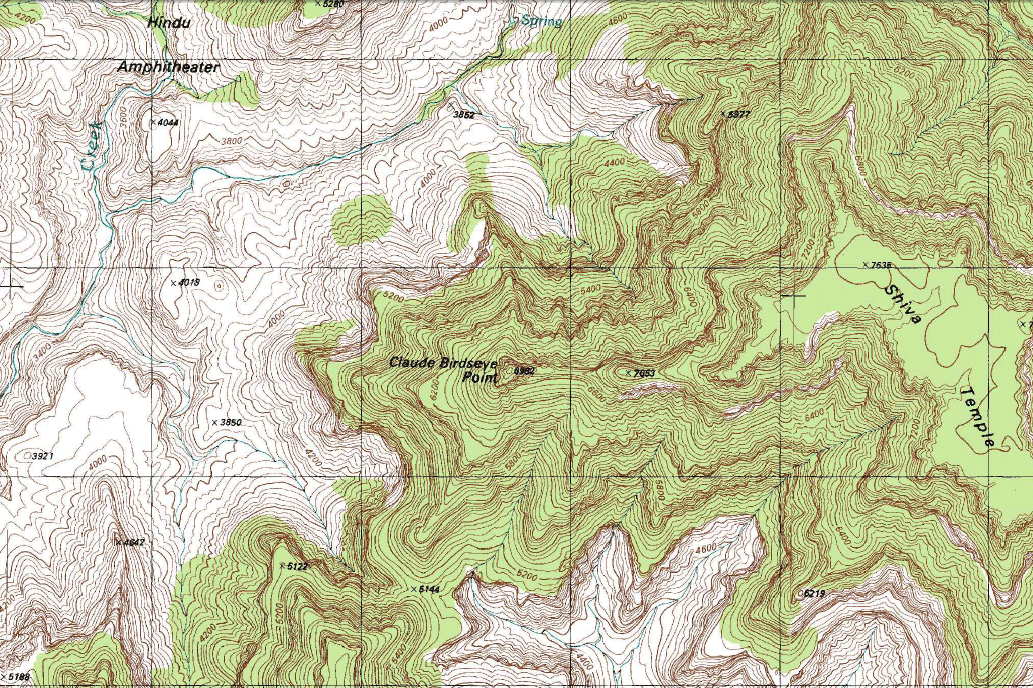
Contour maps add a third dimension to a 2-D map by providing elevation information. An example is a part of the 1:24,000 United States Geological Survey (USGS) topographic map ("topo sheet"), showing a section of the Grand Canyon. This information is shown in the form of isolines that connect points having the same elevation. The resulting web of fine (usually) brown lines can be a little confusing, but there are a few simple rules governing contour lines:
- Contour lines never split or divide: If you find a line that does, it's something other than a contour line (e.g., a stream, road, fault).
- A contour line must represent one and only one elevation.
- A contour line may never intersect or touch other contour lines (though they may appear to if they're describing a landscape having overhanging cliffs).
- Elevations on one side of a given contour line are higher than those on the other side of that line.
- The contour interval (how many meters or feet there are between adjacent contour lines) remains the same over a map, unless exceptions are noted in the legend.
- Contour lines never simply end: They always close back on themselves if seen on a map of sufficiently small scale (large area). If they close back on themselves within a map, they form irregular bull's eye patterns; if the map is too large scale (that is, shows too little area), the contour lines will extend to the end of the page and then you won't see them closing into a bull's eye pattern.
- Concentric circles of contour lines indicate a hilltop or mountain peak.
- Concentric circles of hachured contour lines indicate a closed depression. Hachures are very short lines sticking out at right angles from the main contour line (making it look like a caterpillar, sort of).
- When going upslope and then into a depression, the first hachured contour line of the depression has the same elevation as the last unhachured line crossed.
- Contour lines form a V-pattern crossing streams. The "V" always points upstream, and its apex is always in the stream channel.
- Contour lines bulge downslope in a rounded "U" shaped pattern when crossing hilly ridges between streams or canyons.
- Closely spaced contour lines represent a steep slope; widely spaced lines indicate a gentle slope.
- Every fourth or fifth contour line is shown with a thicker line. This thicker contour line is called an index contour and, if you follow it, you'll eventually find a nice round number elevation printed along it somewhere. This makes it easier to interpret the terrain in the area of the index contour.
To build your skills in interpreting contour maps, I've drawn a simplified topographic map, shown in Figure 1. It represents a hilly terrain in an area approximately 90 km by 70 km in size. On it, note that a small "x" is placed by each of six locations, each designated by a letter. Have a close look at this and get your bearings, so you know which of the lines on it are contour lines and which are not. Now, answer the following questions about it:
- What is the contour interval for this map? You need to infer it from
counting the unmarked lines from one index contour line to the next and then
dividing the difference between the index contours by that number of lines.
__________ - What is the elevation of point B (you need to interpolate between contour
lines here)?
__________ - How about F?
__________ - Which of the lettered points has the highest elevation?
__________ - Which has the lowest elevation?
__________ - Which pair of lettered points has roughly the same elevation?
__________ - After examining the depression in the northwest corner, the elevation of
its floor lies below which elevation?
__________but above which elevation?__________ - Draw the kind of line used to represent a stream here (an intermittant
one)?
- In general, the stream system flows in which direction? From the east
side of the map to the west side or from the west side to the east side?
__________ - What makes you think so?
_________________________________________________________________________ _________________________________________________________________________- What do the contour lines do every time they intersect a stream channel?
_________________________________________________________________________- You may see the contour lines doing the same thing in places where a stream is not shown (yet). Draw in the smaller (even more intermittant) channels, making sure their connections to the shown streams make sense in light of gravity.
- Which of the following three points lies above the steepest slope (elevation gradient)? _____B _____E _____F
- Explain your choice.
_________________________________________________________________________ _________________________________________________________________________- A bit about the scale of the map.
- How long is the graphic scale at the bottom of the map (in
centimeters)? _____
- This distance in centimeters represents 25 km on the ground. How many
kilometers does just one cm represent? (divide 25 by the length of the graphic
scale in cm) __________ cm
- Put another way, one cm equals __________ km. You have just created a
verbal scale for this map.
- Convert these kilometers into meters by multiplying them by 1000:
__________
- Convert the meters into centimeters by multiplying them by 100:
__________
- So, in other words, one centimeter on this map equals __________ cm on
the ground. You have just calculated the representative fraction scale
of
the map. Representative fractions are nice, because it doesn't make any
difference which measurement system you use (one inch on the map equals 24,000
inches in the real world or one centimeter on the map equals 24,000
centimeters in the real world, whatever).
(Verbal scales and representative fractions are messed up, though, if you change the size of the map, but a graphic scale holds true no matter what size the map is, because it shrinks and grows with the map. The other two scales have to be recalculated any time you change the size of a map.) - The bigger the fraction, the larger the map's scale. Som a large scale map has a small denominator in its representative fraction and provides large amounts of detail about a small area of the earth's surface. A small scale map has a small representative fraction (large denominator) and provides small amounts of detail about a large part of the earth's surface. So, compared to the Grand Canyon map, is Figure 1 a relatively __________ large scale or relatively __________ small scale map?
- About how far is point C from point F in kilometers, as the bird flies?
__________ km- Explain how you figured that.
_________________________________________________________________________ _________________________________________________________________________- For the heck of it, do the same for points C and B.
__________ km- In which direction would you be traveling if you made a straight-line trip from C to B?
__________- Extra, extra credit: What would the azimuth of that trip be? Hunh? Take a protractor and center it on the x marked C, with the 0°/360° line going straight up (north) from there (parallel with the left border). Now, the line crossing through point B crosses the protractor at which angle (how many degrees clockwise from 0° or north)? Voilà: your azimuth.
__________- Now, draw a cross-section of a straight-line trip from point C to point B. To do this, perform the following steps:
- Lay a straight-edged card or piece of paper on the map from the middle of
the X at C to the middle of the x at B.
- Every place a contour line touches the edge of your card, make a thin
mark on the card.
- Next to it, mark the elevation represented by that contour line.
- When you're done with that, create an X-Y graph, showing distance on the
X axis (horizontal one), going from 0 at C to whatever at B (in kilometers).
Mark the axis in kilometers, with nice round numbers (e.g., tens or fives).
The easiest thing to do is to make the X axis as long as the distance in
centimeters or inches from C to B (this way, you don't need to transform the
distances mathematically to be proportionate to a longer axis). Be aware,
though, that this will be a dinky graph (especially since the Y axis shouldn't
be longer than the X axis or it'll look funny).
- On the Y axis (vertical one), show elevation in meters. This axis needs
to show all the elevations marked on your card (plus maybe another 100 m on
either end of the range, just to be safe).
- Now, lay the card over your X axis and put a tick mark on the axis
wherever there's one on the card. So, your X axis is going to be "hachured"
wherever you put one of those tick marks.
- Then, for each tick mark, put a dot directly above it in the body of the
graph at the elevation of the contour line which crossed the card there.
- Lastly, connect all the dots with a smoothly flowing line to show the
profile of the landscape from C to B (its cross section).
- After looking at that cross-section, there certainly are a lot of uncomfortable ups mixed in with the downs for anyone taking the beeline approach from C to B. Not fun for the lazy hiker. On the map, draw a recommended path from C to B that will keep the hiker moving mostly downward (except maybe right below B), which is an easier hike though a longer one. Look for a path that goes through areas with widely spaced contours (low slope angle) and takes advantage of the easier hiking a stream provides.
Lab 10b: Building Your Own Contour Map
In this section of the lab, you get to build your own contour map, instead of interpreting mine. Figure 2 shows a landscape, at this point depicting nothing but the streams in the area and a series of points for which elevations have been surveyed, in meters. What you get to do is draw in the contour lines, using a 20 meter contour interval and showing all contours from 60 m to 200 m. Before you do, make sure to review the rules governing contour lines above. Take the following steps to make this as easy on yourself as possible:
- Find the highest point on the map (_____m) and the lowest (_____m). This
will help you get your bearings on the general lay of the land.
- Figure out the direction of stream flow. You can figure this out from the
elevations given for points near the streams and also by observing the
intersections between streams (where tributaries come together to form a
larger stream). They intersect in a "V" pattern, and the apex of the "V"
points downstream.
- Start drawing in the lowest elevation contour line first and then do the
next higher one and so on. Draw the lines in very lightly in pencil at first,
as you will probably change your mind a few times as you get more familiar
with the process. Darken them in or do them in ink only when you are totally
sure you "got it" and are happy with your lines' placement.
- To do the lines, you need to interpolate ("eyeball") the position of
points in areas where there are no points of known elevation. The landscape
is a continuous surface, and you can assume very crudely that a contour
elevation will be located proportionally to its value between two points of
known elevation. In other words, if you're trying to draw in the 160 m
contour line and you have a point with a value of 170 m on one side and
another marked 155 m on the other, you can assume that the contour elevation
of 160 is probably about one third of the way between the 155 m point and the
170 m point (because 160 is one third of the way between the two numbers).
- Remember that, whenever contour lines cross streams, you have to stretch
the contour line upstream to form a "V," and the apex of the "V" has to
coïncide exactly with the stream itself.
- To help you get started, I've created a version of this map that shows the 100 m contour line. You'll find
that you can make its neighbors kind of parallel it, and that works until you
get to the part of the landscape where there are hills and you have to start
creating concentric circles around them.
- Make index contour lines for any contour that is an even multiple of 100.
This line should be heavier than the other contour lines and you should leave
some white space along it in one or two places to write the index elevation
right in line (see Figure 1 to view a couple of index
contours).
Figure 1 -- Topographic map for interpretation in Lab 10a.
![[ topographic map ]](https://home.csulb.edu/~rodrigue/geog140/labs/contourfig1.gif)
Figure 2 -- Map of elevations and streams on which you'll create a contour map
![[ map of surveyed elevations and streams ]](https://home.csulb.edu/~rodrigue/geog140/labs/contourfig2.gif)
Figure 3 -- Figure 2 map, showing the 100 m contour line as a starting point
![[ map of surveyed elevations and streams ]](https://home.csulb.edu/~rodrigue/geog140/labs/contourstarted.jpg)
first placed on the web: 11/12/99
last revised: 05/03/08
© Dr. Christine M. Rodrigue